
Burundi is located in East Africa, to the east of the Democratic Republic of the Congo, at the coordinates 3°30′S30°0′E.

The Democratic Republic of the Congo (DRC) is the largest country of sub-Saharan Africa, occupying some 2,344,858 square kilometres (905,355 sq mi). Most of the country lies within the vast hollow of the Congo River basin. The vast, low-lying central area is a plateau-shaped basin sloping toward the west, covered by tropical rainforest and criss-crossed by rivers. The forest center is surrounded by mountainous terraces in the west, plateaus merging into savannas in the south and southwest. Dense grasslands extend beyond the Congo River in the north. High mountains of the Ruwenzori Range are found on the eastern borders with Rwanda and Uganda.

The Republic of Equatorial Guinea is located in west central Africa. Bioko Island lies about 40 kilometers (24.9 mi) from Cameroon. Annobón Island lies about 595 kilometres (370 mi) southwest of Bioko Island. The larger continental region of Río Muni lies between Cameroon and Gabon on the mainland; it includes the islands of Corisco, Elobey Grande, Elobey Chico, and adjacent islets. The total land area is 28,051 km2 (10,831 sq mi). It has an Exclusive Economic Zone of 303,509 km2 (117,185 sq mi).

Ghana is a West African country in Africa, along the Gulf of Guinea.

The geography of Israel is very diverse, with desert conditions in the south, and snow-capped mountains in the north. Israel is located at the eastern end of the Mediterranean Sea in West Asia. It is bounded to the north by Lebanon, the northeast by Syria, the east by Jordan and the West Bank, and to the southwest by Egypt. To the west of Israel is the Mediterranean Sea, which makes up the majority of Israel's 273 km (170 mi) coastline, and the Gaza Strip. Israel has a small coastline on the Red Sea in the south.

Lebanon is a small country in the Eastern Mediterranean, located at approximately 34˚N, 35˚E. It stretches along the eastern shore of the Mediterranean Sea and its length is almost three times its width. From north to south, the width of its terrain becomes narrower. Lebanon's mountainous terrain, proximity to the sea, and strategic location at a crossroads of the world were decisive factors in shaping its history.

The Nile is a major north-flowing river in northeastern Africa. It flows into the Mediterranean Sea. The Nile is the longest river in Africa and has historically been considered the longest river in the world, though this has been contested by research suggesting that the Amazon River is slightly longer. Of the world's major rivers, the Nile is one of the smallest, as measured by annual flow in cubic metres of water. About 6,650 km (4,130 mi) long, its drainage basin covers eleven countries: the Democratic Republic of the Congo, Tanzania, Burundi, Rwanda, Uganda, Kenya, Ethiopia, Eritrea, South Sudan, Sudan, and Egypt. In particular, the Nile is the primary water source of Egypt, Sudan and South Sudan. Additionally, the Nile is an important economic river, supporting agriculture and fishing.

Sierra Leone is a country in West Africa with a North Atlantic Ocean coastline to the west. It lies on the African Plate. The country's main geographical features include wooded hill country, an upland plateau, and mountains in the east. The highest peak is Mount Bintumani, which is 1,948 meters (6,391 ft) above sea level. The coastline has a belt of mangrove swamps. Freetown, the nation's capital city, has one of the world's largest natural harbours. The Rokel River is the largest river in Sierra Leone. It is 400 kilometres (250 mi) long and has a basin with a total area of 10,622 square kilometres (4,101 sq mi).

Sudan is located in Northeast Africa. It is bordered by Egypt to the north, the Red Sea to the northeast, Eritrea and Ethiopia to the east, South Sudan to the south, the Central African Republic to the southwest, Chad to the west and Libya to the northwest. Sudan is the third largest country in Africa, after Algeria and the Democratic Republic of the Congo. It had been the largest country on the continent until the 2011 independence of South Sudan.

Lake Chad is an endorheic freshwater lake located at the junction of four countries: Nigeria, Niger, Chad, and Cameroon in western and central Africa respectively, with a catchment area of 1 million square kilometres (390,000 sq mi). Lake Chad is divided into deeper southern parts and shallower northern parts. The water source of the lake mainly comes from rivers such as the Chari River that enter the lake. The water level varies greatly seasonally, and the area of the lake also changes dramatically.

Lake Victoria is one of the African Great Lakes. With a surface area of approximately 59,947 km2 (23,146 sq mi), Lake Victoria is Africa's largest lake by area, the world's largest tropical lake, and the world's second-largest fresh water lake by surface area after Lake Superior in North America. In terms of volume, Lake Victoria is the world's ninth-largest continental lake, containing about 2,424 km3 (1.965×10⁹ acre⋅ft) of water. Lake Victoria occupies a shallow depression in Africa. The lake has an average depth of 40 m (130 ft) and a maximum depth of 80–81 m (262–266 ft). Its catchment area covers 169,858 km2 (65,583 sq mi). The lake has a shoreline of 7,142 km (4,438 mi) when digitized at the 1:25,000 level, with islands constituting 3.7% of this length.
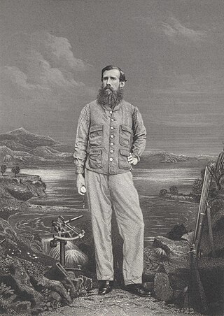
Captain John Hanning Speke was an English explorer and officer in the British Indian Army who made three exploratory expeditions to Africa. He is most associated with the search for the source of the Nile and was the first European to reach Lake Victoria.

The Ruzizi is a river, 117 kilometres (73 mi) long, that flows from Lake Kivu to Lake Tanganyika in Central Africa, descending from about 1,500 metres (4,900 ft) to about 770 metres (2,530 ft) above sea level over its length. The steepest gradients occur over the first 40 kilometres (25 mi), where hydroelectric dams have been built. Further downstream, the Ruzizi Plain, the floor of the Western Rift Valley, has gentle hills, and the river flows into Lake Tanganyika through a delta, with one or two small channels splitting off from the main channel.

Pielinen is the fourth largest lake of Finland, with a drainage basin area of 12,823 km2 (4,951 sq mi) equally distributed between eastern Finland and Russia. The creation of the lake and its outlet is attributed to a post-glacial isostatic rebound, which resulted in uplift of the land. As is common in Finnish lakes, the lake's color is dark, due to the high proportion of bogs present in the catchment of the drainage basin that drains humic substances.

Ripon Falls at the northern end of Lake Victoria in Uganda was formerly considered the source of the river Nile. In 1862–63 John Hanning Speke was the first European to follow the course of the Nile downstream after discovering the falls that his intuition had marked as the source of the Nile.

Kigoma Region is one of Tanzania's 31 administrative regions. The regional capital is the city of Kigoma. Kigoma Region borders Kagera Region, Geita Region, Katavi Region, Tabora Region, DRC and Burundi According to the 2012 national census, the region had a population of 2,127,930, which was higher than the pre-census projection of 1,971,332. For 2002-2012, the region's 2.4 percent average annual population growth rate was tied for the fourteenth highest in the country. It was also the sixteenth most densely populated region with 57 people per square kilometer. With a size of 45,066 square kilometres (17,400 sq mi), the region is slightly smaller than Estonia.

Mono is one of the twelve departments of Benin, with its capital at Lokossa. It is named for the Mono River which forms much of the border with Togo. The northern areas of the department were split off to create the newly formed Kouffo Department in 1999. Mono is subdivided into six communes, each centred at one of the principal towns, namely, Athiémè, Bopa, Comè, Grand-Popo, Houéyogbé and Lokossa. It has an area of 1,396 square kilometres (539 sq mi).

The Albertine Rift is the western branch of the East African Rift, covering parts of Uganda, the Democratic Republic of the Congo (DRC), Rwanda, Burundi and Tanzania. It extends from the northern end of Lake Albert to the southern end of Lake Tanganyika. The geographical term includes the valley and the surrounding mountains.

Lake Jipe is an inter-territorial lake straddling the borders of Kenya and Tanzania. On the Kenyan side, it is located south of the village of Nghonji while on the Tanzanian side, it is situated within Mwanga District, in Kilimanjaro Region. The lake is fed mainly by the Lumi River, which descends from Mount Kilimanjaro, as well as streams from the North Pare Mountains, being on the leeward side. The lake's outlet forms the Ruvu River. Kenya's unfenced Tsavo West National Park protects part of the lake's northern shore, while on the Tanzania side Mkomazi Game Reserve is nearby. The lake is known for its endemic fish, as well as water birds, mammals, wetland plants and lake-edge swamps, which can extend 2 kilometres (1.2 mi) from Jipe's shore.

The Pangani River, is a major river of northeastern Tanzania. It has two main sources: the Ruvu, which rises as Lumi at Kilimanjaro, passes through Lake Jipe, and empties into the Nyumba ya Mungu Reservoir, and the Kikuletwa River, coming from the west and mainly fed by rivers of Mount Meru in Arusha Region, which also enters into the Nyumba ya Mungu Reservoir in Kilimanjaro Region. Just after leaving the reservoir the stream becomes the main Pangani, which empties into the Indian Ocean in Tanga Region at the Tangan port town of Pangani.

