
The Sydney Harbour Bridge is a steel through arch bridge in Sydney, New South Wales, Australia, spanning Sydney Harbour from the central business district (CBD) to the North Shore. The view of the bridge, the Harbour, and the nearby Sydney Opera House is widely regarded as an iconic image of Sydney, and of Australia itself. Nicknamed "the Coathanger" because of its arch-based design, the bridge carries rail, vehicular, bicycle and pedestrian traffic.

Trigg County is a county located on the far southwest border of the U.S. state of Kentucky. As of the 2020 census, the population was 14,061. Its county seat is Cadiz. Formed in 1820, the county was named for Stephen Trigg, an officer in the American Revolutionary War who was killed at the Battle of Blue Licks, now in Robertson County, Kentucky. It was a victory for British and allied troops.

E-ZPass is an electronic toll collection system used on toll roads, toll bridges, and toll tunnels in the Eastern, Midwestern, and Southeastern United States. The E-ZPass Interagency Group (IAG) consists of member agencies in several states, which use the same technology and allow travelers to use the same transponder on toll roads throughout the network.

The Henry Hudson Bridge is a double-deck steel arch toll bridge in New York City across the Spuyten Duyvil Creek. It connects Spuyten Duyvil in the Bronx with Inwood in Manhattan to the south, via the Henry Hudson Parkway. On the Manhattan side, the parkway goes into Inwood Hill Park. Commercial vehicles are not permitted on this bridge or on the parkway in general.
U.S. Route 68 is a United States highway that runs for 560 miles (900 km) from northwest Ohio to Western Kentucky. The highway's western terminus is at US 62 in Reidland, Kentucky. Its present eastern terminus is at Interstate 75 in Findlay, Ohio, though the route once extended as far north as Toledo. US 68 intersects with US 62 three times during its route.

The Newark Bay Bridge, officially the Vincent R. Casciano Memorial Bridge, is a steel through arch bridge that is continuous across three spans. It crosses Newark Bay and connects the cities of Newark and Bayonne in New Jersey, United States. It was completed April 4, 1956, as part of the New Jersey Turnpike's Newark Bay Extension, with a ribbon-cutting ceremony led by Governor of New Jersey Robert B. Meyner.

The Carquinez Bridge is a pair of parallel bridges spanning the Carquinez Strait at the northeastern end of San Francisco Bay. They form the part of Interstate 80 between Crockett and Vallejo, California, United States.

The Oak Street Bridge is a crossing over the north arm of the Fraser River, the Canada Line, and several roads, in Metro Vancouver.

Bixby Bridge, also known as Bixby Creek Bridge, on the Big Sur coast of California, is one of the most photographed bridges in California due to its aesthetic design, "graceful architecture and magnificent setting". It is a reinforced concrete open-spandrel arch bridge. The bridge is 120 miles (190 km) south of San Francisco and 13 miles (21 km) south of Carmel in Monterey County on State Route 1.

Kentucky Route 80 (KY 80) is a 483.55-mile-long (778.20 km) state highway in the southern part of the U.S. state of Kentucky. The route originates on the state's western border at Columbus in Hickman County and stretches across the southern portion of the state, terminating southeast of Elkhorn City on the Virginia state line. It is the longest Kentucky State Highway, though the official distance as listed in route logs is much less due to multiple concurrencies with U.S. Route 68 (US 68) and US 23.

The Fort Pitt Bridge is a steel, double-decked bowstring arch bridge that spans the Monongahela River near its confluence with the Allegheny River in Pittsburgh, Pennsylvania. It carries Interstate 376 between the Fort Pitt Tunnel and Downtown Pittsburgh. Opened in June 1959 as a replacement for the Point Bridge, the Fort Pitt Bridge was the world's first computer-designed bowstring arch bridge and double-decked bowstring arch bridge. The bridge is known for its difficult lane changes, especially on the lower level, often requiring people to go from the extreme left lane across two lanes to the extreme right lane in only 700 feet. The upper level is more forgiving for some routes but still requires a full span lane change in 700 feet to get from the south side entrance to the downtown exits.

Kentucky Lake is a major navigable reservoir along the Tennessee River in Kentucky and Tennessee. It was created in 1944 by the Tennessee Valley Authority's impounding of the Tennessee River via Kentucky Dam for flood control and hydroelectric power. The 160,309-acre (649 km2) lake is the largest artificial lake by surface area in the United States east of the Mississippi River, with 2,064 miles (3,322 km) of shoreline. Kentucky Lake has a flood storage capacity of 4,008,000 acre⋅ft (4.944 km3), more than 2.5 times the next largest lake in the TVA system.

The Fort Henry Bridge is a crossing of the Ohio River main channel in Wheeling, West Virginia. The tied-arch bridge carries two lanes in each direction of Interstate 70 (I-70), U.S. Route 40 (US 40), and US 250. The bridge opened after four years of construction work on September 8, 1955, costing $6.8 million, $1.8 million over budget. The bridge, along with the aging Wheeling Suspension Bridge, are the only two road links from Wheeling Island to downtown Wheeling, although this is the only one that allows vehicular traffic. In 2009, the structure carried an average of over 60,000 vehicles per day.
The Centennial Bridge is a through arch bridge road bridge over the Missouri River connecting Leavenworth, Kansas, and Platte County, Missouri. Constructed in 1955, it was initially a toll bridge. The bridge opened in 1955, a year after Leavenworth celebrated its centennial as the first city incorporated in Kansas. It is a two-span arch bridge connecting K-92 and Missouri Route 92. Its main span is 419.8 feet, and its total length is 2,571.2 feet. During the construction a spur of Route 45 called the "Leavenworth cutoff" was built to speed traffic to Kansas City, Missouri. The two-mile spur, even though it is in Missouri, was maintained by the city of Leavenworth until the tolls were removed from the Centennial Bridge in May 1977. The bridge is now maintained by the Kansas Department of Transportation.
An underwater tunnel is a tunnel which is partly or wholly constructed under the sea or a river. They are often used where building a bridge or operating a ferry link is unviable, or to provide competition or relief for existing bridges or ferry links. While short tunnels are often road tunnels which may admit motorized traffic, unmotorized traffic or both, concerns with ventilation lead to the longest tunnels being electrified rail tunnels.

The Brookport Bridge is a ten-span, steel deck (grate), narrow two-lane truss bridge that carries U.S. Route 45 (US 45) across the Ohio River in the U.S. states of Illinois and Kentucky. It connects Paducah, Kentucky, north to Brookport, Illinois.

Interstate 75 (I-75) is a part of the Interstate Highway System that runs 1,786.47 miles (2,875.04 km) from Miami Lakes, Florida to the Canada–United States border at Sault Ste. Marie, Michigan. In the U.S. state of Kentucky, I-75 runs through the eastern half of the state, from the Tennessee state line near the city of Williamsburg to the Ohio state line near Covington. The Interstate serves the state's second-most populous city, Lexington. Outside of it, the route is mostly rural or suburban in nature, mainly providing access to other cities via state and U.S. Highways. The major landscapes traversed by I-75 include the rolling hills and mountains of the Cumberland Plateau, the flat Bluegrass region, the urban core of Lexington, and the highly urbanized suburbs of Northern Kentucky; it also very briefly crosses through the Eastern Kentucky Coalfield at its southernmost stretch and passes near the Daniel Boone National Forest in London.
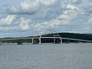
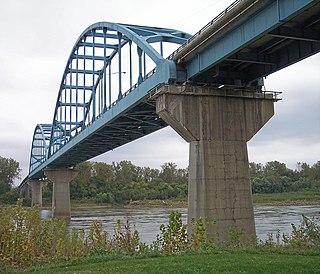
Eggner Ferry Bridge, also known as Eggner's Ferry Bridge, is a four-lane bridge in Trigg and Marshall counties in the U.S. state of Kentucky. The current through-arch bridge opened to traffic on April 7, 2016, replacing a two-lane bowstring truss bridge constructed in 1932. The bridge carries US 68 and Kentucky Route 80 across Kentucky Lake. The main span of the original 1932 bridge collapsed on January 26, 2012, after it was hit by a ship. There were no injuries. The bridge was repaired and reopened to traffic on May 25 of that year. On the morning of July 25, 2016, the middle four spans of the old Eggner's Ferry Bridge were brought down using controlled explosives.

R/S RocketShip, formerly M/V Delta Mariner, is a roll-on/roll-off cargo ship operated by Keystone Shipping Company for United Launch Alliance (ULA). Her primary role is transporting components for the ULA Atlas V, Delta IV and Vulcan rockets from the manufacturer, located in Decatur, Alabama, to launch facilities at Cape Canaveral Space Force Station in Florida and Vandenberg Space Force Base in California.
The Clay's Ferry Bridge is a bridge that carries Interstate 75 along with US 25 and US 421 across the Kentucky River between Madison and Fayette counties.
