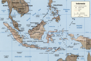
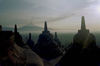
Unlike other temples, which were built on a flat surface, Borobudur was built on a bedrock hill, 265m (869ft)above sea level and 15m (49ft) above the floor of the dried-out paleolake.[1] The lake's existence had been the subject of intense discussion among archaeologists in the 20th century; Borobudur was thought to have been built on a lake shore or even surrounded by a lake.
Nieuwenkamp's proposition
In 1931, a Dutch artist and scholar of Hindu and Buddhist architecture, W.O.J. Nieuwenkamp, developed a theory that Kedu Plain was once a lake and Borobudur initially represented a lotus flower floating on the lake.[2] Lotus flowers are found in almost every Buddhist work of art, often serving as a throne for buddhas and base for stupas. The architecture of Borobudur itself suggests a lotus depiction, in which Buddha postures in Borobudur symbolize the Lotus Sutra, mostly found in many Mahayana Buddhism (a school of Buddhism widely spread in the east Asia region) texts. Three circular platforms on the top are also thought to represent a lotus petals.[1]
Nieuwenkamp has suggested that the landscape near Borobudur included lakes, and that the temples were arranged around these lakes in form of flowers and mathematical patterns considered to be auspicious, and that the temples were connected by paved brick roads lined by walls. These lakes and roads were later filled with metres of volcanic ash from the multiple eruptions of Mount Merapi, which lies very closely to the east of the area.
Nieuwenkamp's theory, however, was contested by many archaeologists, such as Dumarçay and Soekmono, arguing the natural environment surrounding the monument was dry land. This theory is controversial, but recent geological evidence supports Nieuwenkamp proposal.[citation needed][3][4]
Palynological investigation and geomorphology analysis
Dumarçay together with Professor Thanikaimoni had taken soil samples in 1974 and again in 1977 from trial trenches that had been dug into the hill, as well as from the plain immediately to the south. These samples were later analysed by Professor Thanikaimoni, who examined their pollen and spore content in order to identify the type of vegetation that had grown in the area around the time of Borobudur's construction. They were unable to discover any pollen or spore samples that were characteristic of any vegetation known to grow in an aquatic environment. The area surrounding Borobudur appears to have been surrounded by agricultural land and palm trees at the time of the monument's construction, as is still the case today.
Caesar Voûte and the geomorphologist Dr J.J. Nossin in 1985–86 field studies re-examined the Borobudur lake hypothesis and concluded the absence of a lake around Borobudur at the time of its construction and active use as a sanctuary.
These findings were endorsed by UNESCO in A New Perspective on Some Old Questions Pertaining to Borobudur compiled within the 2005 UNESCO publication titled "The Restoration of Borobudur".
Geological findings
In 2000s, geologists, on the other hand, support Nieuwenkamp's view, pointing out clay sediments found near the site.[5] A study of stratigraphy, sediment and pollen samples conducted in 2000 supports the existence of a paleolake environment near Borobudur,[1] which tends to confirm Nieuwenkamp's theory.[relevant?]
The lake area fluctuated with time and the study also proves that Borobudur was near the lake shore c. 13th and 14th centuries. River flows and volcanic activities shape the surrounding landscape, including the lake. One of the most active volcanoes in Indonesia, Mount Merapi's has been very active since the Pleistocene.[6][citation needed]
Conclusion
The location Borobudur surroundings, the ancient lake as suggested once located in south-southeast from Borobudur, and probably south from Mendut temple on Progo and Elo rivers confluence.
To reconcile among these findings, it seems that there was once a lake near Borobudur during its construction and at the time of its initial active use in the 9th century. However contrary to Nieuwenkamp's theory — of Borobudur as a blossoming lotus in the center of the pond — the lake was not surrounding the whole Borobudur of the bedrock hill completely, but just some small sections of it [citation needed].
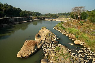
It might be possible that the lower parts of the Kedu plains surrounding Borobudur near the river, was once naturally flooded and created a small shallow lake for at least until 13th to 14th century. The nearest portion of this elongated lake was estimated to be located around 500 metres south from Borobudur along the small river that drained to the southeast where it joins the Progo river. The lake just flooded the lower portion of the valley located in south and southeast from the temple, while the east, west and northern sides are dry lands probably cultivated as rice paddies, orchards and palm trees just like today. There were probably other lakes located several hundred metres south from Mendut temple on Progo and Elo rivers confluence, and north from Pawon temple along Progo river. These lakes existed until the 13th to 14th centuries, when Merapi's volcanic activity, collapsed the natural dam barrier and finally drained the lake.
Notes
1 2 3 Murwanto, H.; Gunnell, Y; Suharsono, S.; Sutikno, S.; Lavigne, F (2004). "Borobudur monument (Java, Indonesia) stood by a natural lake: chronostratigraphic evidence and historical implications". The Holocene. 14 (3): 459–463. doi:10.1191/0959683604hl721rr. S2CID129690872.
↑ J.G. de Casparis, "The Dual Nature of Barabudur", in Gómez and Woodward (1981), page 70 and 83.
↑ Murwanto, H.; Gunnell, Y; Suharsono, S.; Sutikno, S. and Lavigne, F (2004). “Borobudur monument (Java, Indonesia) stood by a natural lake: chronostratigraphic evidence and historical implications”. The Holocene 14 (3): 459–463
↑ Newhall C.G., Bronto S., Alloway B., Banks N.G., Bahar I., del Marmol M.A., Hadisantono R.D., Holcomb R.T., McGeehin J., Miksic J.N., Rubin M., Sayudi S.D., Sukhyar R., Andreastuti S., Tilling R.I., Torley R., Trimble D., and Wirakusumah A.D. (2000). “10,000 Years of explosive eruptions of Merapi Volcano, Central Java: archaeological and modern implications”. Journal of Volcanology and Geothermal Research 100 (1): 9–50
↑ R.W. van Bemmelen (1949). The geology of Indonesia, general geology of Indonesia and adjacent archipelago, vol 1A, The Hague, Government Printing Office, Martinus Nijhoff. cited in Murwanto (2004).
↑ Newhall C.G.; Bronto S.; Alloway B.; Banks N.G.; Bahar I.; del Marmol M.A.; Hadisantono R.D.; Holcomb R.T.; McGeehin J.; Miksic J.N.; Rubin M.; Sayudi S.D.; Sukhyar R.; Andreastuti S.; Tilling R.I.; Torley R.; Trimble D.; Wirakusumah A.D. (2000). "10,000 Years of explosive eruptions of Merapi Volcano, Central Java: archaeological and modern implications". Journal of Volcanology and Geothermal Research. 100 (1): 9–50. doi:10.1016/S0377-0273(00)00132-3.
Borobudur, also transcribed Barabudur is a 9th-century Mahayana Buddhist temple in Magelang Regency, not far from the city of Magelang and the town of Muntilan, in Central Java, Indonesia. It is the world's largest Buddhist temple. The temple consists of nine stacked platforms, six square and three circular, topped by a central dome. It is decorated with 2,672 relief panels and originally 504 and 300 of them are damaged Buddha statues. The central dome is surrounded by 72 Buddha statues, each seated inside a perforated stupa.
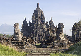
Prambanan is a 9th-century Hindu temple compound in the Special Region of Yogyakarta, in southern Java, Indonesia, dedicated to the Trimūrti, the expression of God as the Creator (Brahma), the Preserver (Vishnu) and the Destroyer (Shiva). The temple compound is located approximately 17 kilometres (11 mi) northeast of the city of Yogyakarta on the boundary between Central Java and Yogyakarta provinces.
Mount Merapi, Gunung Merapi, is an active stratovolcano located on the border between the province of Central Java and the Special Region of Yogyakarta, Indonesia. It is the most active volcano in Indonesia and has erupted regularly since 1548. It is located approximately 28 km (17 mi) north of Yogyakarta city which has a population of 2.4 million, and thousands of people live on the flanks of the volcano, with villages as high as 1,700 m (5,577 ft) above sea level.
The Sunda Arc is a volcanic arc that produced the volcanoes that form the topographic spine of the islands of Sumatra, Nusa Tenggara, and Java, the Sunda Strait and the Lesser Sunda Islands. The Sunda Arc begins at Sumatra and ends at Flores, and is adjacent to the Banda Arc. The Sunda Arc is formed via the subduction of the Indo-Australian Plate beneath the Sunda and Burma plates at a velocity of 63–70 mm/year.
The Shailendra dynasty was the name of a notable Indianised dynasty that emerged in 8th-century Java, whose reign signified a cultural renaissance in the region. The Shailendras were active promoters of Mahayana Buddhism with the glimpses of Hinduism, and covered the Kedu Plain of Central Java with Buddhist monuments, one of which is the colossal stupa of Borobudur, now a UNESCO World Heritage Site.
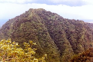
Turgo is a small basaltic hill on the southern slopes of Mount Merapi, Indonesia, and is also known as Gunung Turgo or Mount Turgo. It is administratively located in Purwobinangun, Pakem, Sleman Regency, Special Region of Yogyakarta. Recent work suggests that the hill itself is older than the present volcanic cone of Gunung Merapi. It is just west of Plawangan, the valley between the two has been subject to nuée ardente in the 1990s which killed local villagers.
Magelang is one of six cities in Central Java that are administratively independent of the regencies in which they lie geographically. Each of these cities is governed by a mayor rather than a bupati. Magelang city covers an area of 18.12 km2 and has a population of 118,227 at the 2010 census and 121,526 at the 2020 census. It is located in the middle of the Magelang Regency, between Mount Merbabu and Mount Sumbing in Central Java Province, Indonesia, and lies 43 km north of Yogyakarta, 15 km north of Mungkid and 75 km south of Semarang, the capital of Central Java.
The Mataram Kingdom ; also known as Medang Kingdom was a Javanese Hindu–Buddhist kingdom that flourished between the 8th and 11th centuries. It was based in Central Java, and later in East Java. Established by King Sanjaya, the kingdom was ruled by the Shailendra dynasty and Ishana dynasty.
Yogyakarta is the capital city of Special Region of Yogyakarta in Indonesia, in the south-central part of the island of Java. As the only Indonesian royal city still ruled by a monarchy, Yogyakarta is regarded as an important centre for classical Javanese fine arts and culture such as ballet, batik textiles, drama, literature, music, poetry, silversmithing, visual arts, and wayang puppetry. Renowned as a centre of Indonesian education, Yogyakarta is home to a large student population and dozens of schools and universities, including Gadjah Mada University, the country's largest institute of higher education and one of its most prestigious.
Sleman Regency is an Indonesian regency on the island of Java. It is located in the north of the Yogyakarta Special Administrative Region, Indonesia, and has an area of 574.82 square kilometres (221.94 sq mi), with a population of 1,093,110 at the 2010 Census and 1,125,804 at the 2020 Census. Its capital is the town of Sleman. The current regent is Kustini Sri Purnomo.
Magelang is a regency in Central Java, Indonesia, famous for its 9th century Buddhist temple of Borobudur. Its capital is Mungkid. It covers an area of 1,085.73 km2 and had a population of 1,181,723 at the 2010 Census and 1,299,859 at the 2020 Census. These figures exclude the autonomous city of Magelang, which is separately administered but is geographically enclaved within the regency, which borders Temanggung Regency to the north, Semarang Regency to the northeast, Boyolali Regency to the east, the Special Region of Yogyakarta to the south and southeast, Purworejo Regency to the southwest, and Wonosobo Regency to the west. Its motto is Magelang Gemilang.
A candi is a Hindu or Buddhist temple in Indonesia, mostly built during the Zaman Hindu-Buddha or "Hindu-Buddhist period" between circa the 4th and 15th centuries.
Kedu Plain, also known as Progo River valley, is the fertile volcanic plain that lies between the volcanoes Mount Sumbing and Mount Sundoro to the west, and Mount Merbabu and Mount Merapi to the east. It roughly corresponds to present-day Magelang and Temanggung Regency of Central Java, Indonesia.
Sewu is an eighth century Mahayana Buddhist temple located 800 metres north of Prambanan in Central Java, Indonesia. The word for a Hindu or Buddhist temple in Indonesian is "candi," hence the common name is "Candi Sewu." Candi Sewu is the second largest Buddhist temple complex in Indonesia; Borobudur is the largest. Sewu predates nearby "Loro Jonggrang" temple at Prambanan. Although the complex consists of 249 temples, this Javanese name translates to 'a thousand temples,' which originated from popular local folklore. Archaeologists believe the original name for the temple compound to be Manjusrigrha.
Candi Asu is part of the Sengi complex built in the 8th and 9th centuries. It is a Hindu temple lying in Magelang Regency, Central Java. It is nestled in between Mount Merapi and Mount Merbabu volcanoes and near the road from Mungkid to Boyolali.
Wijnand Otto Jan Nieuwenkamp, was a Dutch multi-faceted autodidact. As an artist he was active as a painter, draftsman, sculptor, etcher, lithographer, and designer of book covers and of ex-libris. In addition, he was also known as a writer, architect, explorer, ethnologist and collector of East Asian art.
Borobudur Temple Compounds is the World Heritage designation of the area of three Buddhist temples in Central Java, Indonesia. It comprises Borobudur, Mendut, and Pawon. The temples were built during the Shailendra dynasty around the 8th and 9th centuries CE, and fall on a straight line.
Kewu Plain, also known as Prambanan Plain or Opak River valley, is a fertile volcanic plain that lies between Merapi-Merbabu complex in the north, Bantul lowlands and Sewu karst limestone range in the south, Bengawan Solo river valley in the east, the Progo River in the west, and Kedu Plain on northwest. It is located within the Yogyakarta Special Region, Sleman Regency, Klaten Regency and Solo City, Indonesia.
The Progo River is a river in southern central Java, Indonesia. The river passes through two provinces; Central Java and Yogyakarta Special Region. The source of the river is on the slopes of Mount Sindoro, Central Java.
Ngawen is an 8th-century Buddhist temple compound in Magelang Regency, Central Java, Indonesia. Located in Ngawen village, Muntilan sub-district, 6 km (3.7 mi) to the east of Mendut temple or 5 km (3.1 mi) to the south of Muntilan town center. Ngawen temple compound consists of five temples, however today only one is successfully reconstructed.
This page is based on this Wikipedia article Text is available under the CC BY-SA 4.0 license; additional terms may apply. Images, videos and audio are available under their respective licenses.