The Lake Hawdon System Important Bird Area comprises an area of 374 square kilometres (144 square miles) covering a series of five coastal lakes in the Limestone Coast of South Australia. They are the most important of a string of regional lakes occupying swale corridors between modern and historical sand dunes. [1]
The Limestone Coast is a name used since the early twenty-first century for a South Australian government region located in the south east of South Australia which immediately adjoins the continental coastline and the Victorian border. The name is also used for a tourist region and a wine zone both located in the same part of South Australia.
South Australia is a state in the southern central part of Australia. It covers some of the most arid parts of the country. With a total land area of 983,482 square kilometres (379,725 sq mi), it is the fourth-largest of Australia's states and territories by area, and fifth largest by population. It has a total of 1.7 million people, and its population is the second most highly centralised in Australia, after Western Australia, with more than 77 percent of South Australians living in the capital, Adelaide, or its environs. Other population centres in the state are relatively small; Mount Gambier, the second largest centre, has a population of 28,684.
In physical geography, a dune is a hill of loose sand built by aeolian processes (wind) or the flow of water. Dunes occur in different shapes and sizes, formed by interaction with the flow of air or water. Most kinds of dunes are longer on the stoss (upflow) side, where the sand is pushed up the dune, and have a shorter "slip face" in the lee side. The valley or trough between dunes is called a slack. A "dune field" or erg is an area covered by extensive dunes.
The Important Bird Area (IBA) lies between the towns of Robe and Beachport. It includes the following lakes listed in order from north to south - Hawdon, Robe, Eliza, St Clair and George, and the area extending for a distance of one kilometre (0.62 mi) inland from each in order to include habitat used by critically endangered orange-bellied parrots. Characteristics of the lakes are: [1]
An Important Bird and Biodiversity Area (IBA) is an area identified using an internationally agreed set of criteria as being globally important for the conservation of bird populations.
Robe is a town and fishing port located in the Limestone Coast of South Australia. The town's distinctive combination of historical buildings, ocean, fishing fleets, lakes and dense bush is widely appreciated. Robe lies on the southern shore of Guichen Bay, just off the Princes Highway. At the 2006 census, Robe had a population of 1,246. Robe is the main town in the District Council of Robe local government area. It is in the state electorate of MacKillop and the federal Division of Barker.
A critically endangered (CR) species is one that has been categorized by the International Union for Conservation of Nature (IUCN) as facing an extremely high risk of extinction in the wild.
The wetland system was identified by BirdLife International as an IBA because it regularly supports over 1% of the world populations of red-necked stint, and often of sharp-tailed sandpipers, double-banded plovers and banded stilts. It also provides habitat for orange-bellied parrots, Australasian bitterns, rufous bristlebirds and striated fieldwrens. [1] The adjacent beaches and offshore islets, from Cowrtie Island[ clarification needed ] to Baudin Rocks, sometimes support breeding fairy terns. [1]
BirdLife International is a global partnership of conservation organisations that strives to conserve birds, their habitats, and global biodiversity, working with people towards sustainability in the use of natural resources. It is the world's largest partnership of conservation organisations, with over 120 partner organisations.
The red-necked stint is a small migratory wader. The genus name is from Ancient Greek kalidris or skalidris, a term used by Aristotle for some grey-coloured waterside birds. The specific ruficollis is from Latin rufus, "red" and collum, "neck".
The sharp-tailed sandpiper is a small wader.
While the IBA has no statutory status, it does overlap the following protected areas declared by the South Australian government: Beachport Conservation Park, Lake Robe Game Reserve, Lake St Clair Conservation Park and Little Dip Conservation Park. [1]
The Government of South Australia, also referred to as the South Australian Government, is the Australian state democratic administrative authority of South Australia. The Government of South Australia, a parliamentary constitutional monarchy, was formed in 1856 as prescribed in its Constitution, as amended from time to time. Since the Federation of Australia in 1901, South Australia has been a state of the Commonwealth of Australia, and the Constitution of Australia regulates its relationship with the Commonwealth. Under the Australian Constitution, South Australia ceded legislative and judicial supremacy to the Commonwealth, but retained powers in all matters not in conflict with the Commonwealth.
Beachport Conservation Park, formerly the Beachport National Park, is a protected area located in the Limestone Coast of South Australia about 80 kilometres north-west of Mount Gambier and immediately north of the township of Beachport.
Lake Robe Game Reserve is a protected area located about 6 kilometres south of the town of Robe in South Australia. It covers the saline lake, Lake Robe, and some surrounding land and also immediately adjoins the northern boundary of the Little Dip Conservation Park. It was proclaimed on 4 November 1993 to protect "valuable habitats for a variety of waterbirds, and terrestrial mammals notably the hooded plover, sharp-tailed sandpiper, and the swamp rat " and to manage recreational duck hunting activity. The area is classified as an IUCN Category VI protected area.
Lake Macquarie or Awaba is Australia's largest coastal salt water lagoon. Located in the Hunter Region of New South Wales, it covers an area of 110 square kilometres (42.5 sq mi) and is connected to the Tasman Sea by a short channel. Most of the residents of the City of Lake Macquarie live near the shores of the lake.
The Tuggerah Lakes, a wetland system of three interconnected coastal lagoons, are located on the Central Coast of New South Wales, Australia and comprise Lake Munmorah, Budgewoi Lake and Tuggerah Lake.
Lake Victoria is a 139-hectare (340-acre) shallow saline lake on the Bellarine Peninsula, Victoria in Australia, close to the township of Point Lonsdale and part of the Lonsdale Lakes Nature Reserve administered by Parks Victoria.
Lake Connewarre, a shallow estuarine 880-hectare (2,200-acre) lake on the Barwon River, is located on the Bellarine Peninsula southeast of Geelong in the Australian state of Victoria.
Tarcutta Hills Reserve is a 432-hectare (1,070-acre) nature reserve on the lower western slopes of the Great Dividing Range in central west New South Wales, Australia. It is 427 kilometres (265 mi) south-west of Sydney, close to the Hume Highway, and 15 kilometres (9.3 mi) south of Tarcutta. It is owned and managed by Bush Heritage Australia (BHA), which purchased it in 1999, and it is listed on the Register of the National Estate.
Lake Warden is a salt lake in the Goldfields-Esperance region of Western Australia. It and its associated wetlands are protected in a nature reserve; they were recognised as being of international importance under the Ramsar Convention through designation of the Lake Warden System on 7 June 1990 as Ramsar Site 485. The lake is also a DIWA-listed wetland.
Lake Gore is a seasonal and semi-permanent freshwater lake in the Goldfields-Esperance region of Western Australia located approximately 24 km (15 mi) west of Esperance. It is an important site for waterbirds.
Murtnaghurt Lagoon, also known as Murtnaghurt Swamp or Lake Murtnaghurt, is a shallow, ephemeral wetland west of the town of Barwon Heads on the southern coast of the Bellarine Peninsula in Victoria, Australia. It comprises two enclosed depressions, elongated west-east and separated by a low ridge. The wetland is about 2 kilometres (1.2 mi) in length, and up to 600 metres (2,000 ft) wide, with 4.5 kilometres (2.8 mi) of shoreline enclosing an area of 81 hectares. It is connected by a narrow 2.7 kilometres (1.7 mi) palaeochannel extending from the lagoon northwards to the main tidal channel of the lower Barwon River.
The Discovery Bay Coastal Park is a linear protected area of coastal land in western Victoria, south-eastern Australia. The 10,460-hectare (25,800-acre) park extends along the coast of Discovery Bay from Cape Nelson north-westwards for 50 kilometres (31 mi) to the border with South Australia. The park was listed on Australia’s now-defunct Register of the National Estate, and lies within the traditional lands of the Gunditjmara people.
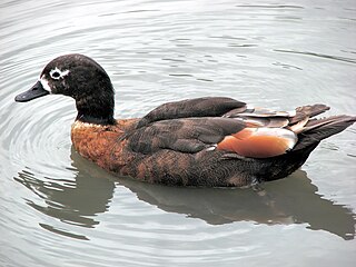
The Western District Lakes of Victoria, in the Western District of Victoria, south-eastern Australia, were recognised on 15 December 1982 as wetlands of international importance by listing under the Ramsar Convention, as Ramsar site no.268.
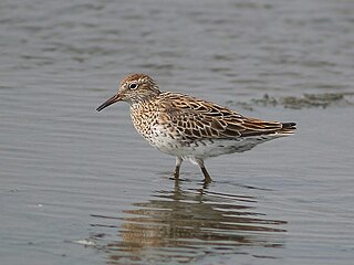
Lake McLarty is a 219-hectare (540-acre) freshwater lake and associated nature reserve on the Swan Coastal Plain of Western Australia. The lake is named after a prominent pioneering family which settled in the district in the early 1860s. It lies about 90 kilometres (56 mi) south of Perth on the eastern side of the Harvey Estuary and forms part of the Peel-Yalgorup System Ramsar site. It is an important area for waders, or shorebirds, and is a well-known birdwatching site.
Lake Newland Conservation Park is a protected area in the Australian state of South Australia located on the west coast of the Eyre Peninsula about 10 kilometres (6.2 mi) north of the town of Elliston. It was proclaimed in 1991 in order to protect Lake Newland, a hypersaline lake, and an associated wetland complex.
The Menindee Lakes is a chain of shallow ephemeral freshwater lakes connected to the Darling River to form a storage system. The lakes lie in the far west region of New South Wales, Australia, near the town of Menindee.
The Yambuk Important Bird Area comprises a 10 km2 tract of coastal land fronting Bass Strait in south-western Victoria, south-eastern Australia. It lies some 20 km west of the town of Port Fairy and encompasses the lower reaches of the Eumeralla River and Lake Yambuk.
Yashilkul is a freshwater lake in Gorno-Badakhshan Autonomous Province, in southeast Tajikistan, about 130 kilometres (81 mi) east of the provincial capital of Khorugh. Lying in the upper Gunt valley of the Pamir Mountains, it has an area of 3,600 hectares with a maximum depth of 52 metres (171 ft). It lies 1.5 kilometres (0.93 mi) from a similar lake, Bulunkul, both of which are surrounded by other wetlands as well as sand and pebble plains. The lake forms part of the Bulunkul and Yashilkul lakes and mountains Important Bird Area.
The Kattasay and Daganasay Reservoirs Important Bird Area comprises two irrigation reservoirs and their surrounds in central Sughd Province in northwestern Tajikistan. Together, they have been identified as a 98 square kilometres (38 sq mi) Important Bird Area (IBA) by BirdLife International.
Little Dip Conservation Park is a protected area in the Australian state of South Australia located in the Limestone Coast about 105 kilometres north-west of Mount Gambier and about 5 kilometres south of the town of Robe. It was proclaimed as a conservation park under the National Parks and Wildlife Act 1972 in 1975 for the purpose of conserving 'remnant vegetation and a chain of small lakes which combine to provide habitat for several endangered and vulnerable bird species' and managing 'the increasing use' of the locality 'for recreation purposes'. The conservation park is classified as an IUCN Category VI protected area.
Lake Hawdon South Conservation Park is a protected area located in the Australian state of South Australia in the locality of Bray about 280 kilometres (170 mi) south-east of the state capital of Adelaide and about 18 kilometres (11 mi) east of the town of Robe.
Coordinates: 37°16′34″S139°55′35″E / 37.27611°S 139.92639°E
A geographic coordinate system is a coordinate system that enables every location on Earth to be specified by a set of numbers, letters or symbols. The coordinates are often chosen such that one of the numbers represents a vertical position and two or three of the numbers represent a horizontal position; alternatively, a geographic position may be expressed in a combined three-dimensional Cartesian vector. A common choice of coordinates is latitude, longitude and elevation. To specify a location on a plane requires a map projection.
This South Australia geography article is a stub. You can help Wikipedia by expanding it. |