Staples Township is a township in Todd County, Minnesota, United States. The population was 622 at the 2000 census and in the 2020 census it was 597.

Como Lake is a 70.5-acre (285,000 m2) lake up to 15.5 feet (4.7 m) deep in St. Paul, Minnesota, United States. It, along with the neighboring Como Park, has been a recreation area for residents of the Twin Cities for more than a century. It was named in 1848 by local farmer Charles Perry. A pavilion sits on the west side of the lake, and plays host to theatrical performances and concerts during the warmer months. The park features a variety of attractions, including the Como Park Zoo and Conservatory and the Como Regional Park Pool.

Lake Nokomis is one of several lakes in Minneapolis, Minnesota, and part of the city's Chain of Lakes. The lake was previously named Lake Amelia in honor of Captain George Gooding's daughter, Amelia, in 1819. Its current name was adopted in 1910 to honor Nokomis, grandmother of Hiawatha. It is located in the southern part of the city, west of the Mississippi River and south of Lake Hiawatha. The lake is oval in shape, with a long axis running southwest to northeast. Two pathways circle the lake, a 2.7-mile (4.3 km) pedestrian trail and a 2.8-mile (4.5 km) bicycle trail. Because the lower part of the lake is crossed by Cedar Avenue running north–south, the impression from the ground is that the lake is shaped like an L. The lake has an area of 204 acres (0.83 km2).
Bde Maka Ska is the largest lake in Minneapolis, Minnesota, United States, and part of the city's Chain of Lakes. Surrounded by city park land and circled by bike and walking trails, it is popular for many outdoor activities. The lake has an area of 401 acres (1.62 km2) and a maximum depth of 87 feet (27 m).

Lake of the Isles is a lake in Minneapolis, Minnesota, connected to Cedar Lake and Bde Maka Ska. The lake is part of the city's Chain of Lakes and has an area of 109 acres (0.4 km2), 2.86 miles (4.6 km) of shoreline with a little under three miles of paved walking and biking paths, and a maximum depth of 31 feet (9 m). Lake of the Isles is known for its two wooded islands, its long north arm, and the surrounding stately houses of the Kenwood, Lowry Hill, and East Isles neighborhoods.

The Grand Rounds National Scenic Byway is a linked series of park areas in Minneapolis, Minnesota, United States, that takes a roughly circular path through the city. The Minneapolis Park and Recreation Board developed the system over many years. The corridors include roads for automobile traffic plus separate paths for pedestrians and bicycles, and extend slightly into neighboring cities. About 50 miles (80 km) of roadway and paths are in the system, and much of it was built in the 1930s as part of Civilian Conservation Corps projects.

Lake Harriet is a lake in southwest Minneapolis, south of Bde Maka Ska and north of Minnehaha Creek. The lake is surrounded by parkland as part of Minneapolis’ Chain of Lakes. The lake has an area of 335 acres (1.36 km2) and a maximum depth of 85 feet (26 m).

Cedar Lake is a lake in Minneapolis, Minnesota, United States, and part of the city's Chain of Lakes. It is located on the west side of the city, north of Bde Maka Ska and west of Lake of the Isles. The lake is surrounded by parkland, with some easements having been made to private homeowners on the southeast side; it is the only lake in the city with private shoreline. The south and west sides border the Cedar-Isles-Dean neighborhood, while the east shore flanks the Kenwood residential area. On the north is the Cedar Lake Trail and the BNSF Railway, and the south Bryn Mawr neighborhood. Cedar Lake has an area of 169 acres (0.68 km2) and a maximum depth of 51 feet (16 m). The Minneapolis Park and Recreation Board manages the lake and parkland around the lake.

Hiawatha is a neighborhood within the larger Longfellow community in Minneapolis. It is bordered by 40th Street to the north, the Mississippi River to the east, 54th Street East to the south, and Hiawatha Avenue to the west. Its neighbors are Howe to the north, the Mississippi River to the east, Minnehaha Park and the Minnehaha neighborhood to the south, and Ericsson and Standish to the west.
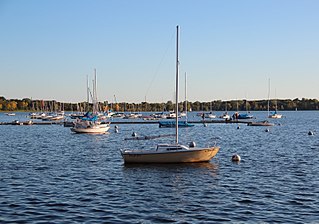
Christmas Lake is a spring-fed lake covering approximately 265 acres (1.1 km2) in the western Minneapolis suburbs of Shorewood and Chanhassen. The lake is crossed by the border of Hennepin and Carver counties, with most of the area lying within the jurisdiction of the former. Christmas Lake is known for its exceptional water clarity, the best in the Minneapolis metropolitan area, with a DNR-reported clarity level of 20 feet (6.10 m). This clarity can be attributed to the fact that Christmas Lake is a spring fed lake with a sandy bottom. Although relatively small in area, Christmas Lake becomes deep very quickly, forming the basin of a depression that extends all along "the Ridge". The steep nature of the shoreline means that many houses are built far above the lake with railed motorized carts to provide access to the docks at the water level.

Bancroft is a neighborhood within the Powderhorn community in Minneapolis, Minnesota, United States. Its boundaries are East 38th Street to the north, Chicago Avenue to the west, East 42nd Street to the south and Cedar Avenue to the east. It is entirely located within Minneapolis City Council Ward 8, represented by Andrea Jenkins.

Nokomis East is a group of neighborhoods in the southeastern corner of Minneapolis, Minnesota, United States. It consists of four neighborhoods: Keewaydin, Minnehaha, Morris Park and Wenonah. Nokomis East contains two schools, the Nokomis Community Library, and a post office. On its western edge is Lake Nokomis, for which it is named. Two regional parks, and three neighborhood parks, provide recreation and educational programming for all age groups. Seven churches serve residents of various denominations. Nokomis East is served by the Nokomis East Neighborhood Association (NENA). The main transportation corridors are the neighborhood boundaries: Cedar Avenue, 34th and 28th Avenues, 50th and 54th Streets, Hwy 55, and Crosstown highway 62.

Greenleaf Lake State Recreation Area is a state park unit of Minnesota, USA, currently in development. It includes undeveloped shoreline on both Greenleaf and Sioux Lakes, halfway between the cities of Hutchinson and Litchfield in Meeker County. Portions of the state recreation area (SRA) are open to the public for day-use recreation, but there are no facilities yet on site. The park boundaries were set by the Minnesota Legislature and the state is still acquiring land from willing sellers; two-thirds of the property remain privately owned.
The Minneapolis Park and Recreation Board (MPRB) is an independent park district that owns, maintains, and programs activities in public parks in Minneapolis, Minnesota, United States. It has 500 full-time and 1,300 part-time employees and an $111 million operating and capital budget.

Lake Byllesby is a 1,432-acre artificial lake on the Cannon River in Dakota and Goodhue counties, in the U.S. State of Minnesota. The lake was formed as a result of construction of the Byllesby Dam by the H.M. Byllesby & Company, which would later become Northern States Power Company for hydroelectric power generation. Today, the lake serves as a popular recreational destination and is the largest lake in Southern Dakota County, approximately 30 miles (48 km) southeast of the Twin Cities.

Medicine Lake is an inland lake located approximately 8 miles northwest of downtown Minneapolis, Minnesota. The lake lies within Hennepin County and is surrounded by two municipalities. At 902 acres, it is Hennepin County's second largest lake behind Lake Minnetonka and is popular among boaters, sailors, and fishers. Medicine Lake's most significant tributary is Plymouth Creek, which enters the lake at West Medicine Lake Park. The lake is also fed by rain and drainage from nearby cities, including Medicine Lake, Plymouth, New Hope, Golden Valley and Minnetonka.

Min Hi Line is a proposed linear park and shared-use path that would eventually re-purpose an active rail and agri-industrial corridor in the Longfellow community of Minneapolis, Minnesota, United States. Modeled after successful projects like the Atlanta Beltline and New York High Line, it would feature an approximately 3-mile (4.8 km), shared-use pathway that traverses housing, retail, commercial buildings, gardens, playgrounds, and public art installments. Two pilot projects completed in 2018 and 2019 connect the Min Hi Line corridor to trail systems at its northern and southern ends.

Minneapolis is often considered one of the top biking and walking cities in the United States due to its vast network of trails and dedicated pedestrian areas. In 2020, Walk Score rated Minneapolis as 13th highest among cities over 200,000 people. Some bicycling ratings list Minneapolis at the top of all United States cities, while others list Minneapolis in the top ten. There are over 80 miles (130 km) of paved, protected pathways in Minneapolis for use as transportation and recreation. The city's Grand Rounds National Scenic Byway parkway system accounts for the vast majority of the city's shared-use paths at approximately 50 miles (80 km) of dedicated biking and walking areas. By 2008, other city, county, and park board areas accounted for approximately 30 miles (48 km) of additional trails, for a city-wide total of approximately 80 miles (130 km) of protected pathways. The network of shared biking and walking paths continued to grow into the late 2010s with the additions of the Hiawatha LRT Trail gap remediation, Min Hi Line pilot projects, and Samatar Crossing. The city also features several natural-surface hiking trails, mountain-biking paths, groomed cross-country ski trails in winter, and other pedestrian walkways.

Hiawatha Golf Course is a golf course adjacent to Lake Hiawatha in Minneapolis, Minnesota. The golf course was listed on the National Register of Historic Places in 2023 for its association with the African American community. The Minneapolis Park Board developed five golf courses in the first three decades of the 20th century, since golf was a relatively new sport at the time and interest was peaking. Black residents in Minneapolis were concentrated in a few neighborhoods, including Southside, so Hiawatha Golf Course became an important social and recreational center for that neighborhood.


