
The Avon River is a river in Western Australia. A tributary of the Swan River, the Avon flows 240 kilometres (150 mi) from source to mouth, with a catchment area of 125,000 square kilometres (48,000 sq mi).

A drainage basin is an area of land where all flowing surface water converges to a single point, such as a river mouth, or flows into another body of water, such as a lake or ocean. A basin is separated from adjacent basins by a perimeter, the drainage divide, made up of a succession of elevated features, such as ridges and hills. A basin may consist of smaller basins that merge at river confluences, forming a hierarchical pattern.

The Wheatbelt is one of nine regions of Western Australia defined as administrative areas for the state's regional development, and a vernacular term for the area converted to agriculture during colonisation. It partially surrounds the Perth metropolitan area, extending north from Perth to the Mid West region, and east to the Goldfields–Esperance region. It is bordered to the south by the South West and Great Southern regions, and to the west by the Indian Ocean, the Perth metropolitan area, and the Peel region. Altogether, it has an area of 154,862 square kilometres (59,793 sq mi).

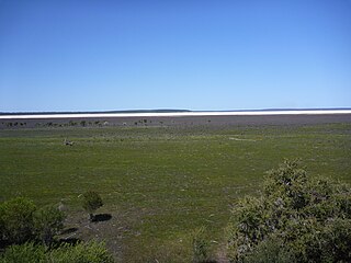
Dumbleyung Lake, also widely known as Lake Dumbleyung, is a salt lake in the Great Southern region of Western Australia. The lake has a length of 13 kilometres (8 mi) and a width of 6.5 kilometres (4 mi); it covers a total area of 52 square kilometres (20 sq mi).

The Ord River is a 651-kilometre long (405 mi) river in the Kimberley region of Western Australia. The river's catchment covers 55,100 square kilometres (21,274 sq mi).

The Mallee is a sub-region of Loddon Mallee covering the most north-westerly part of Victoria, Australia and is bounded by the South Australian and New South Wales borders. Definitions of the south-eastern boundary vary, however, all are based on the historic Victorian distribution of mallee eucalypts. These trees dominate the surviving vegetation through most of Mallee,. Its biggest settlements are Mildura and Swan Hill.
Lake Muir is a freshwater lake, with a larger surrounding wetlands area, that is located in the South West region of Western Australia. The lake lies near Muirs Highway, north of Walpole and southeast of Manjimup.

South Dandalup Dam is a dam in Western Australia. It is located where the South Dandalup River flows out of Lake Banksiadale. The dam was built in 1971 in response to rapid population growth in Perth, Western Australia's capital city, and a resources boom in the Pilbara.

Mallee, also known as Roe Botanical District, is a biogeographic region in southern Western Australia. Located between the Esperance Plains, Avon Wheatbelt and Coolgardie bioregions, it has a low, gently undulating topography, a semi-arid mediterranean climate, and extensive Eucalyptus mallee vegetation. It has an area of 73,975.59 square kilometres (28,562.13 sq mi). About half of the region has been cleared for intensive agriculture. Recognised as a region under the Interim Biogeographic Regionalisation for Australia (IBRA), it was first defined by John Stanley Beard in 1980.
Lake Bryde-East Lake Bryde is a DIWA-listed freshwater wetland system located in the Great Southern region of Western Australia. The system consists of two lakes: Lake Bryde, with an area of 50 hectares ; and East Lake Bryde, with an area of about 1.4 square kilometres (0.54 sq mi). They are located at the head of a chain of lakes that extend to Lake Magenta, and ultimately form part of the Swan-Avon drainage system.
The Nambung River is a river in the Wheatbelt region of Western Australia, 170 kilometres (106 mi) north of Perth. The river drains an area between the towns of Cervantes and Badgingarra. In its lower reaches the Nambung River forms a chain of waterholes in the Nambung Wetlands where it disappears underground into a limestone karst system 5.5 kilometres (3 mi) from the Indian Ocean.
Salt River is a river in the Wheatbelt region of Western Australia. It is a tributary of the Avon River, taking water from two of the Avon's sub-catchments, the Yilgarn River and the Lockhart River, from their junction where it passes through a hydrological-topographical pinch-point at Caroline Gap.
Toolibin Lake is a seasonal fresh to brackish water perched lake or wooded swamp, in south-western Australia. The lake is contained with a 493-hectare (1,218-acre) nature reserve and it is located about 200 kilometres (124 mi) south-east of Perth, in the Shire of Narrogin, and 40 kilometres (25 mi) east of the town of Narrogin, in the Wheatbelt region of Western Australia. The lake is listed by the Australian Government as a threatened ecological community under the Environment Protection and Biodiversity Conservation Act 1999.
Sleaford Mere is a permanent saline lake, located on the Jussieu Peninsula on the south eastern tip of Eyre Peninsula in South Australia about 15 kilometres south west of Port Lincoln. The lake was given its modern name by the British explorer, Matthew Flinders, on 26 February 1802. Since 1969, the lake has been part of the Sleaford Mere Conservation Park and since 2005, it has been listed as a nationally important wetland. The lake and its environs are notable as a venue for recreational pursuits such as canoeing.
Yenyenning Lake, also often spelt Yenyening Lakes, and associated lakes are in the upper Avon River catchment area in Western Australia, and the source of the Avon and Swan River systems.

Lake Austin is an ephemeral salt lake located in the Mid West region of Western Australia, approximately 21 km (13 mi) south of Cue and 55 km (34 mi) north of Mount Magnet. It is named after Robert Austin, who explored the area around the lake in 1854. The abandoned town of Austin is located on an island in the lake. The Great Northern Highway passes through this island as it crosses the lake. Lake Austin is also the name of the locality surrounding it.
The Raak Plain Boinka is a wilderness area in the state of Victoria, Australia. The boinka groundwater discharge complex is a shallow depression within a region of Mallee dune fields, and contains gypsum flats and salinas, pools of salty water that are mainly fed by groundwater. The distinctive flora of the boinka is largely intact and includes several threatened species.

Lake Towerrinning or Towerrinning Lake is a permanent brackish lake in the Wheatbelt region of Western Australia located approximately 32 km (20 mi) south of Darkan, 44 km (27 mi) south west of Wagin and about 245 km (152 mi) south east of Perth. The lake is managed by the Department of Parks and Wildlife since it is used as a recreational facility; the Shire of West Arthur leases part of it as a gazetted water ski area.
Lake Yealering, also known as Yealering Lakes, is an ephemeral salt lake in the Wheatbelt region of Western Australia located on the southern edge of the town of Yealering, 30 km (19 mi) north west of Wickepin and about 250 km (160 mi) south east of Perth.
Yilgarn River is a river in the eastern Wheatbelt region of Western Australia. It is a sub-catchment of the Avon River, and has an area of 55,900 square kilometres (21,600 sq mi). At its junction with Lockhart River, their combined flow passes through a hydrological-topographical pinch-point at Caroline Gap, a geomorphic saddle between Mt Caroline and Mt Stirling.

