Lake Opuatia

Last updated

Lake Opuatia
New Zealand relief map.jpg
Disc Plain red.svg
Lake Opuatia
Lake Opuatia is in the Waikato region of the North Island.
Location Waikato District, Waikato region, North Island
Coordinates 37°26′7.2″S175°03′48.3″E / 37.435333°S 175.063417°E / -37.435333; 175.063417 Coordinates: 37°26′7.2″S175°03′48.3″E / 37.435333°S 175.063417°E / -37.435333; 175.063417
Lake type peat lake
Basin  countries New Zealand
Surface area 7 ha (17 acres)
Surface elevation5 m (16 ft)

Lake Opuatia is a small lake in the much larger Opuatia wetland, which drains from the west into the Waikato River. It lies near the foot of a long valley drained by the Opuatia Stream.

Contents

Geology

The lake is a peat lake, probably formed after Taupō pumice blocked the drainage of the valley about 1,800 years ago, when it swept down the Waikato. [1]

History

The lake was in an area occupied by Ngāti Karewa [2] and Ngāti Tipa. [3] Despite their loyalty to the Crown during the Invasion of the Waikato, [4] their land was also confiscated in 1863. [5] 45,500 acres (18,400 ha) were later returned to some members of Ngāti Tipa, [6] though disputes about ownership continued until 1921. [7]

As part of a policy of opening up land for settlement under the deferred payment scheme, the Government built a bridleway from Churchill, a settlement which then stood on the west bank of the river about 4 mi (6.4 km) west of Rangiriri. By 1881, 10 mi (16 km) of the route to the south of the lake had been opened as far as Glen Murray. By 1883 a through track from the Waikato River to the West Coast was in existence. [8] In 1894 a 12 ft (3.7 m) wide road was recommended. [9] Flax was a local industry for a while. [10]

After survey pegs had been pulled up, when the Counties Act 1886 was invoked to build Opuatia Rd on Māori land, [11] the police, with armed support, arrested 10 men and 8 women in 1894, two of whom were sentenced to two months hard labour. [12]

The government bought 27,407 acres (11,091 ha) in 1895. [13]

Roads in the valley were being metalled in the 1920s. [14]

Schools

Schools used to exist at Churchill, [15] just to the east of the lake, at Orton, 6 km (3.7 mi) to the north, and on Otuiti Rd at Opuatia. [16] Opuatia school was open from 1917 (starting with 20 pupils) [17] to 1973 [18] and is now a community centre. [19] A telephone was connected in 1919. [20] There was also a church in the 1850s. [21]

Wildlife

Aquatic vegetation

The lake has not been surveyed since 1993, when four species of submerged plants were identified, [22] including fennel leaved pondweed. [23] Potamogeton crispus and P.pectinatus, with occasional charophytes Nitella hookeri and Chara corallina. [24]

Fish

Longfin eels have been recorded at the lake. [25]

Riparian vegetation

The lake is in 950 ha (2,300 acres) of wetland, 180 ha (440 acres) of which is peat bog, and the remainder swamp and fen dominated by willow and manuka, with areas of rare restiad bog [25] The understorey has indigenous sedges, Nertera scapanioides, Microtis unifolia, and ferns (matua-rarauhe and kiokio), with raupo at the edges. Weeds include gorse, reed sweet grass and reed canary grass, swamp alder , yellow flag iris, beggarticks and royal fern. Possum and red deer are among the animal pests. [25] Threatened species include orchids and carnivorous bladderworts. [25]

Birds

Canada goose, fernbirds, [23] yellowhammer, chaffinch, riroriro, swallow, pheasant, pūkeko, mallard, harrier and shag have all been recorded in the area. [25]

The lake has been a venue for duck shooters since at least 1921. [26]

Restoration

In 2000 Regional Council agreed to mitigate the effect of flood protection works near Mercer by restoring Opuatia Wetland and flooding 60 ha (150 acres) more frequently. Gorse and willow were sprayed with herbicide and cabbage trees, karamu, manuka, mingimingi, poataniwha, Coprosma rhamnoides, pokaka, flax, Astelia grandis, gahnia, Coprosma tenuicaulis, kahikatea and matai were planted from 2006. [25] A further 10,000 plants have since gone in to reduce nutrients flowing from farmland to wetland. [27]

Opuatia Stream

Glen Murray landing in 1905 Glen Murray landing, Opuatia Stream.jpg
Glen Murray landing in 1905

There is no surface link between the lake and the stream, which flows nearby, and the lake and bog are generally fed by rainwater, except during unusually high floods, when water backs up from the Waikato. [25]

The stream rises near Ponganui Road, about 30 km (19 mi) up from the lake. [28] A water quality monitoring site, about 8 km (5.0 mi) from the headwaters, has water classified as in the worst 25% for like sites in respect of bacteria, clarity and nitrogen. [29] Planting, fencing and goat control have been done in the 18,251 ha (45,100 acres) upper catchment to improve the water quality. [22]

The stream was navigable for about 8 km (5.0 mi) [30] to Glen Murray landing, [31] built about 1895, [32] where Opuatia had a post office in 1911. [33]

Related Research Articles

<span class="mw-page-title-main">Ngāruawāhia</span> Town in Waikato, New Zealand

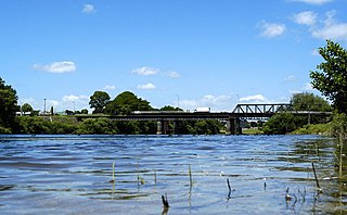
Ngāruawāhia is a town in the Waikato region of the North Island of New Zealand. It is located 20 kilometres (12 mi) north-west of Hamilton at the confluence of the Waikato and Waipā Rivers, adjacent to the Hakarimata Range. Ngāruawāhia is in the Hamilton Urban Area, the fourth largest urban area in New Zealand. The location was once considered as a potential capital of New Zealand.

<span class="mw-page-title-main">Waipā River</span> River in New Zealand

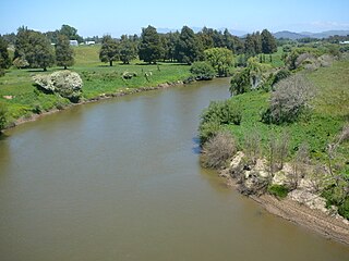
The Waipā River is in the Waikato region of the North Island of New Zealand. The headwaters are in the Rangitoto Range east of Te Kuiti. It flows north for 115 kilometres (71 mi), passing through Ōtorohanga and Pirongia, before flowing into the Waikato River at Ngāruawāhia. It is the Waikato's largest tributary. The Waipā's main tributary is the Puniu River.

<span class="mw-page-title-main">Tīrau</span> Settlement in Waikato, New Zealand

Tīrau is a small town in the Waikato region of the North Island of New Zealand, 50 kilometres southeast of Hamilton. The town has a population of 804. In the Māori language, "Tīrau" means "place of many cabbage trees."

<span class="mw-page-title-main">Kawhia Harbour</span> Harbour and settlement in Waikato, New Zealand

Kawhia Harbour is one of three large natural inlets in the Tasman Sea coast of the Waikato region of New Zealand's North Island. It is located to the south of Raglan Harbour, Ruapuke and Aotea Harbour, 40 kilometres southwest of Hamilton. Kawhia is part of the Ōtorohanga District and is in the King Country. It has a high-tide area of 68 km2 (26 sq mi) and a low-tide area of 18 km2 (6.9 sq mi). Te Motu Island is located in the harbour.

<span class="mw-page-title-main">Putāruru</span> Town in Waikato, New Zealand

Putāruru is a small town in the South Waikato District and the Waikato region of New Zealand's North Island. It lies on the western side of the Mamaku Ranges and in the upper basin of the Waihou River. It is on the Oraka Stream 65 kilometres south-east of Hamilton. State Highway 1 and the Kinleith Branch railway run through the town.

<span class="mw-page-title-main">Flagstaff, Hamilton</span> Suburb of Hamilton, New Zealand

Flagstaff is a suburb in north-east Hamilton, New Zealand. It was originally called Dulverton on council plans, but it was officially named Flagstaff in 1986 when it was declared as a suburb. The area was heavily developed in the 1990s.

<span class="mw-page-title-main">Rototuna</span> Suburb of Hamilton, New Zealand

Rototuna is a suburb in northern Hamilton, New Zealand, east of Flagstaff. It is one of the newest and fastest-growing suburbs in Hamilton, along with neighbouring Huntington and Flagstaff.

<span class="mw-page-title-main">Ngaroto railway station</span> Defunct railway station in New Zealand

Ngaroto railway station was a station on the North Island Main Trunk in New Zealand, 3.42 km (2.13 mi) south of Lake Rd, 2 mi (3.2 km) north of Te Awamutu, beside the entrance to Yarndley's Bush. Lake Ngaroto is visible from the railway to the north of the station.

<span class="mw-page-title-main">Whatawhata</span> Town in Waikato, New Zealand

Whatawhata, previously also spelt Whata Whata, is a small town in the Waikato region on the east bank of the Waipā River, at the junction of State Highways 23 and 39, 12 km (7.5 mi) from Hamilton. Te Araroa tramping route passes through Whatawhata.

<span class="mw-page-title-main">Rangiaowhia</span> Former Village in Waikato region, New Zealand

Rangiaowhia was, for over 20 years, a thriving village on a ridge between two streams in the Waikato region, about 4 km (2.5 mi) east of Te Awamutu. From 1841 it was the site of a very productive Māori mission station until the Invasion of the Waikato in 1864. The station served Ngati Hinetu and Ngati Apakura. Only a church remains from those days, the second oldest Waikato building.

Horotiu is a small township on the west bank of the Waikato River in the Waikato District of New Zealand. It is on the Waikato Plains 13 km (8.1 mi) north of Hamilton and 5 km (3.1 mi) south of Ngāruawāhia. From early in the 20th century it developed around a freezing works and other industries.

Lake Whangape is shallow, supertrophic, lateral and the second largest lake in the lower Waikato River basin in New Zealand. One source said the name translated to 'a large sheet of water', another that it was a chief's name.

<span class="mw-page-title-main">Te Ākau</span> Settlement in Waikato, New Zealand

Te Ākau is a small farming settlement in the North Island of New Zealand, located 62 km (39 mi) north west of Hamilton, 39 km (24 mi) south west of Huntly, 45 km (28 mi) south of Port Waikato and 47 km (29 mi), or 19 km (12 mi) by ferry and road, north of Raglan. It has a hall and a school.

<span class="mw-page-title-main">Whitikahu</span> Locality in Waikato, New Zealand

Whitikahu is a settlement scattered along Whitikahu Rd in the Waikato District and Waikato region of New Zealand's North Island.

<span class="mw-page-title-main">Lake Hakanoa</span> Body of water

Lake Hakanoa is located within the eastern side of the Huntly township, in the Waikato Region of New Zealand. Lake Hakanoa is a riverine lake with links to the Waikato River, which lies 300 m (330 yd) to the west. A smaller lake lies within wetland near the southeastern edge of Hakanoa.

Glen Murray is a rural community in the Waikato District and Waikato region of New Zealand's North Island, on Highway 22, about 6 km (3.7 mi) up the Tikotiko Stream from Lake Whangape. In 2013 the population of meshblock 0846601, which includes Glen Murray, was 42. It has a garage and a War Memorial Hall, which opened in 1952. It is named after William Murray, who moved from Piako in 1885.

Orini is a rural community in the Waikato District and Waikato region of New Zealand's North Island. It is located east of Taupiri

<span class="mw-page-title-main">Motumaoho</span> Village in Waikato, New Zealand

Motumaoho is a small village in the Waikato region of New Zealand's North Island, just to the west of the Pakaroa Range. It is on SH26, 25 km (16 mi) east of Hamilton and 7 km (4.3 mi) west of Morrinsville. The village is bordered by the Waitakaruru Stream to the east. Motumaoho can be translated as an intruding clump of trees.

<span class="mw-page-title-main">Awaroa River (Kawhia Harbour tributary)</span> River in New Zealand

The Awaroa River is a river in the Ōtorohanga District, on the west coast of New Zealand's North Island. It flows north from its source near Te Koraha, through Hauturu to Kawhia Harbour. The river passes through both pasture and indigenous forest. Over half of the river is in forest.

<span class="mw-page-title-main">Te Rore</span> Locality in Waikato region, New Zealand

Te Rore was in the 1850s an important transhipment point on New Zealand's Waipā River, between the agriculture of the Waikato basin and its Auckland market. That was ended in 1864 by the Invasion of the Waikato, when Te Rore was, for a few months, part of the supply route to four redoubts set up nearby. It is now a rural community in the Waipa District, 6 km (3.7 mi) north of Pirongia and roughly the same distance south of Ngāhinapōuri on State Highway 39.

References

  1. Katrina Browne, Dave Campbell, Edmund Brown (19 April 2005). "Ecohydrological Characterisation of Opuatia Wetland and Recommendations for Future Management" (PDF). Environment Waikato Technical Report 2005/17.{{cite web}}: CS1 maint: multiple names: authors list (link)
  2. "Appendix to the Journals of the House of Representatives | 1860 Session I REPORT OF THE WAIKATO COMMITTEE". paperspast.natlib.govt.nz. Retrieved 28 April 2018.
  3. "Appendix to the Journals of the House of Representatives | 1869 Session I First report of the commission of inquiry into the condition and nature of trust estates for religious, charitable, and educational purposes". paperspast.natlib.govt.nz. Retrieved 28 April 2018.
  4. Taonga, New Zealand Ministry for Culture and Heritage Te Manatu. "Kukutai, Waata Pihikete". teara.govt.nz. Retrieved 3 November 2017.
  5. Taonga, New Zealand Ministry for Culture and Heritage Te Manatu. "Confiscation map, 1869". teara.govt.nz. Retrieved 3 February 2018.
  6. "I-02 Native Affairs Committee (reports of). Nga Kupu a Te Komiti O Te Runanga Mo Nga Mea Maori. (colonel Trimble, Chairman.)". Appendix to the Journals of the House of Representatives. 1883 via Papers Past.
  7. "G-06l Native Land Amendment and Native Land Claims Adjustment Act, 1920. Report and Recommendation of Petition No. 138/1916, Relative to Succession to Kima Te Aweawe in Putataka, Lot 18, and Opuatia 11a No. 1 Block". Appendix to the Journals of the House of Representatives via Papers Past.
  8. Susan Williams, CW Vennell (1976). Raglan County Hills and Sea 1876-1976. ISBN   9780868640020.
  9. "Appendix to the Journals of the House of Representatives | 1894 Session I DEPARTMENT OF LANDS AND SURVEY (ANNUAL REPORT ON)". paperspast.natlib.govt.nz. Retrieved 28 April 2018.
  10. "Opuatia Block". New Zealand Herald. 19 September 1895. p. 3. Retrieved 28 April 2018.
  11. "Auckland. — The Opuatia Affair". nzetc.victoria.ac.nz. Retrieved 28 April 2018.
  12. "The Opuatia Survey Dispute". New Zealand Herald. 10 March 1894. p. 5. Retrieved 27 April 2018.
  13. "Appendix to the Journals of the House of Representatives | 1895 Session I LANDS PURCHASED AND LEASED FROM NATIVES IN NORTH ISLAND". paperspast.natlib.govt.nz. Retrieved 28 April 2018.
  14. "Page 14 Advertisements Column 1". New Zealand Herald. 1 October 1923. p. 14. Retrieved 28 April 2018.
  15. E., Mills (1 January 1967). "Opuatia School jubilee, 1917-1967. | National Library of New Zealand". natlib.govt.nz. Retrieved 27 April 2018.
  16. "1 inch map". www.mapspast.org.nz. 1942. Retrieved 27 April 2018.
  17. "Appendix to the Journals of the House of Representatives | 1918 Session I-II". paperspast.natlib.govt.nz. Retrieved 28 April 2018.
  18. "Opuatia roll of honour". nzhistory.govt.nz. Retrieved 27 April 2018.
  19. "Waikato District Sports Park Reserve Management Plan" (PDF). 13 May 2015.
  20. "Appendix to the Journals of the House of Representatives | 1919 Session I". paperspast.natlib.govt.nz. Retrieved 28 April 2018.
  21. "Appendix to the Journals of the House of Representatives | 1858 Session I REPORTS ON NATIVE SCHOOLS". paperspast.natlib.govt.nz. Retrieved 28 April 2018.
  22. 1 2 "Waikato and Waipā River Restoration Strategy" (PDF). Waikato River Authority. April 2018.
  23. 1 2 "Opuatia wetland field trip" (PDF). Botanical Society. 19 November 2005.
  24. "Technical Report 2014/59 Waikato region shallow lakes management plan: Volume 2" (PDF). Waikato Regional Council. 10 October 2014.
  25. 1 2 3 4 5 6 7 "Opuatia Peat Bog Management Plan" (PDF). Waikato Regional Council. June 2011.
  26. "The Shooting Season". New Zealand Herald. 5 May 1921. p. 6. Retrieved 24 April 2018.
  27. "Waikato Regional Council signs new partnership agreement". Waikato River Care. 24 October 2016. Retrieved 24 April 2018.
  28. "Opuatia Stream, Waikato". NZ Topo Map. Retrieved 27 April 2018.
  29. "Opuatia Stm at Ponganui Rd River Quality". Land, Air, Water Aotearoa (LAWA). Retrieved 27 April 2018.
  30. "Appendix to the Journals of the House of Representatives | 1921 Session I-II AUCKLAND CANALS AND INLAND WATERWAYS COMMISSION. (REPORT OF THE)". paperspast.natlib.govt.nz. Retrieved 28 April 2018.
  31. "Streams Made Navigable". New Zealand Herald. 7 March 1929. p. 10. Retrieved 27 April 2018.
  32. Parliament, New Zealand (1895). Parliamentary Debates - Bregmen's Landing, Opuatia River.
  33. "Appendix to the Journals of the House of Representatives | 1911 Session I Post and Telegraph Department (Report of the) for the year 1910-11". paperspast.natlib.govt.nz. Retrieved 27 April 2018.