
Limestone is a common type of carbonate sedimentary rock. It is composed mostly of the minerals calcite and aragonite, which are different crystal forms of calcium carbonate. Limestone forms when these minerals precipitate out of water containing dissolved calcium. This can take place through both biological and nonbiological processes, though biological processes have likely been more important for the last 540 million years. Limestone often contains fossils, and these provide scientists with information on ancient environments and on the evolution of life.

The Ural Mountains or simply the Urals, are a mountain range that runs approximately from north to south through western Russia, from the coast of the Arctic Ocean to the river Ural and northwestern Kazakhstan. The mountain range forms part of the conventional boundary between the regions of Europe and Asia. Vaygach Island and the islands of Novaya Zemlya form a further continuation of the chain to the north into the Arctic Ocean.

Potash includes various mined and manufactured salts that contain potassium in water-soluble form. The name derives from pot ash, which refers to plant ashes or wood ash soaked in water in a pot, which was the primary means of manufacturing the product before the Industrial Era. The word "potassium" is derived from "potash".

Yaroslavl Oblast is a federal subject of Russia, which is located in the Central Federal District, surrounded by Tver, Moscow, Ivanovo, Vladimir, Kostroma, and Vologda oblasts.

Vladimir Oblast is a federal subject of Russia. Its administrative center is the city of Vladimir, which is located 190 kilometers (120 mi) east of Moscow. As of the 2010 Census, the oblast's population was 1,443,693.
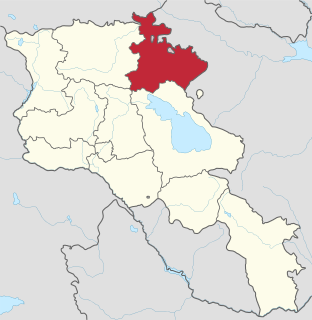
Tavush, is a province of Armenia. It is located at the northeast of Armenia and bordered by Georgia from the north and Azerbaijan from the east. It is domestically bordered by the Gegharkunik Province from the south, Kotayk Province from the southwest and Lori Province from west. The capital and largest city of the province is the town of Ijevan.
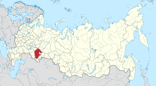
The Republic of Bashkortostan, also called Bashkiria, is a republic of Russia located between the Volga and the Ural Mountains in Eastern Europe. It covers 143,600 square kilometres and has a population of 4 million. It is Russia's most populous republic. Its capital and largest city is Ufa.

Phlogopite is a yellow, greenish, or reddish-brown member of the mica family of phyllosilicates. It is also known as magnesium mica.
Yessentuki is a city in Stavropol Krai, Russia, located in the shadow of Mount Elbrus at the base of the Caucasus Mountains. The city serves as a railway station in the Mineralnye Vody—Kislovodsk branch, and is located 43 kilometers (27 mi) southwest of Mineralnye Vody and 17 kilometers (11 mi) west of Pyatigorsk. It is considered the cultural capital of Russia's Greek population and even today close to ten percent of its population is of Greek descent. Population: 100,996 (2010 Census); 81,758 (2002 Census); 85,082 (1989 Census).
Pyatigorsk is a city in Stavropol Krai, Russia located on the Podkumok River, about 20 kilometers (12 mi) from the town of Mineralnye Vody where there is an international airport and about 45 kilometers (28 mi) from Kislovodsk. Since January 19, 2010, it has been the administrative center of the North Caucasian Federal District of Russia. Population: 142,511 (2010 Census); 140,559 (2002 Census); 129,499 (1989 Census).

Tuva or Tyva, officially the Tyva Republic, is a federal subject of Russia.
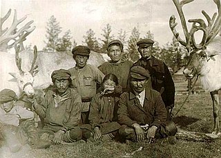
The Tofalar or Tofa people, are a Turkic people in the Irkutsk Oblast in Russia. Their ethnonym contains the Turkic plural suffix -lar, thus it means "Tofas". Their origins, Tofa language and culture are close to those of the eastern Tuvans-Todzhins. Before the 1917 October Revolution, the Tofalar used to be engaged in nomadic, living in the taiga; they engaged in reindeer husbandry and hunting. The Tofalar were resettled by the Soviet government by 1932. Young Tofas learned Russian at new Soviet-built schools, while cultural traditions such as hunting and shamanism were discouraged or prohibited. According to the 2010 census, there were 762 Tofas in Russia.

The Abazin, Abazinians or Abaza, are an ethnic group of the Northwest Caucasus, closely related to the Abkhaz and Circassian people. They live mostly in Turkey, Egypt and in Karachay-Cherkessia and Stavropol Krai in the North Caucasus region of Russia. The Tapanta (ru:Тапанта), a branch of the Abaza, lived between the Besleney and Kabardian princedoms on the upper Kuban.

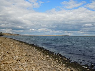
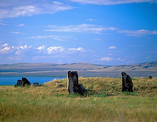
Lake Shira is a meromictic lake, located in the Republic of Khakassia, Russia. The lake covers an area of 39.5 km2 (15.3 sq mi) in a steppe landscape in the Minusinsk Hollow, a relatively flat intermountain area 160 km northwest of the city of Abakan. The village for which it is named, Shira, is 12 kilometers (7.5 mi) to the west. The southern and western shores feature beaches popular for local recreation, and spas that take advantage of the mineral water. Lake Shira is a salt lake with a high magnesium content. It has one small river providing inflow, but no outflow, although geographically the lake is in the Yenisei River basin. The northern shore is protected by the Khakasski Nature Reserve.

The Caspian Sea is the world's largest inland body of water, variously classed as the world's largest lake or a full-fledged sea. An endorheic basin, it lies between Europe and Asia; east of the Caucasus, west of the broad steppe of Central Asia, south of the fertile plains of Southern Russia in Eastern Europe, and north of the mountainous Iranian Plateau of Western Asia. It covers 371,000 km2 (143,000 sq mi) and a volume of 78,200 km3 (19,000 cu mi). It has a salinity of approximately 1.2%, about a third that of average seawater. It is bounded by Kazakhstan from mid-north to mid-east, Russia from mid-north to mid-west, Azerbaijan to the southwest, Iran to the south and adjacent corners, and Turkmenistan along southern parts of its eastern coast.
Tylihul Estuary also called Tiligulskiy liman or simply Tiligul is a Ramsar listed government protected estuary or liman of the Tylihul River. Located in Odessa Oblast in the south of Ukraine, the estuary includes an ornithological Game Reserve and the Tylihulskyi Regional Landscape Park situated on the East coast.
Khakasski Nature Reserve is a Russian 'zapovednik' covering two large mountain areas, and a cluster of seven steppe sites located within the left bank of the Minusinsk depression. The reserve is situated in the Tashtypsky District of Khakassia. It was originally created to preserve steppe ecosystems, wetlands and waterfowl nesting sites, and a historical complex of monuments and cemeteries from the 4-11 centuries BC. The reserve is particularly noted for its variety of large lakes on the Yenisei River migration route for birds. The current configuration of protected sectors was established in 1999, and covers a total area of 267,483 ha (1,032.76 sq mi).

Käina seamud deposit is a national mineral resource deposit in Estonia, Hiiu County, located in the western part of Käina Bay, Hiiumaa Island. In accordance to the Earth's Crust Act sea mud is a mineral resource in Estonia. Käina seamud deposit is one of 3 national seamud deposits in Estonia. The active reserve of the Käina seamud deposit in December, 2018 was 273,8 thousand tons and passive reserve 1 546,0 thousand tons.

Internationally, the terminology on curative mud is not uniform. According to the latest proposal for a new definition, by Gomes at al. (2013), a “peloid is a maturated mud or muddy dispersion with healing and/or cosmetic properties, composed of a complex mixture of fine-grained natural materials of geologic and/or biologic origins, mineral water or sea water, and commonly organic compounds from biological metabolic activity”. Peloid is often used only for the sea curative mud.

Lake Pikrolimni is an endorheic, alkaline salt lake in Kilkis prefecture, Greece. It is located on the border of the Kilkis and Thessaloniki regional units, about 40 km northwest of Thessaloniki. The lake is hypersaline, has rather shallow waters (0.5–0.7 m) and a shoreline of about 8.5 km. The water surface area shows significant seasonal variation (3.2–4.5 km2) due to evaporation in the summer months, with an average value of 3.7 km2.

