The Taupō Volcanic Zone (TVZ) is a volcanic area in the North Island of New Zealand. It has been active for at least the past two million years and is still highly active.
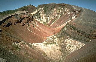
Mount Tarawera is a volcano on the North Island of New Zealand within the older but volcanically productive Ōkataina Caldera. Located 24 kilometres southeast of Rotorua, it consists of a series of rhyolitic lava domes that were fissured down the middle by an explosive basaltic eruption in 1886. While the 1886 eruption was basaltic, study has shown there was only a small basalt component to the previous recent rhyolitic predominant eruptions. This eruption was one of New Zealand's largest historical eruptions, and killed an estimated 120 people. The fissures run for about 17 kilometres (11 mi) northeast–southwest.

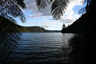
Lake Tikitapu, more commonly known as Blue Lake, is the smallest of four small lakes lying between Lake Rotorua and Lake Tarawera in the Bay of Plenty Region of New Zealand. The other three are Lake Rotokakahi, Lake Ōkāreka, and Lake Ōkataina.

Te Wairoa was a village close to the shore of Lake Tarawera near Rotorua, New Zealand. The village was buried by volcanic ash in the 1886 eruption of Mount Tarawera. It was later excavated and is now open as a tourist destination, the Buried Village. The nearby Wairere Falls are also a tourist destination.
Lake Rotokākahi or Green Lake, is one of four small lakes lying between Lake Rotorua and Lake Tarawera in the Bay of Plenty Region of New Zealand's North Island. The others are Lake Tikitapu, Lake Ōkāreka, and Lake Ōkataina. All lie within the Ōkataina Caldera, along its western edge.
Lake Ōkāreka is one of four small lakes lying between Lake Rotorua and Lake Tarawera, in the Bay of Plenty Region of New Zealand's North Island. The others are Lake Rotokakahi, Lake Tikitapu, and Lake Ōkataina. All lie within the Ōkataina Caldera, along its western edge.
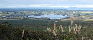
Lake Rerewhakaaitu is a small, shallow lake in northern New Zealand, located 30 kilometres to the east of Rotorua. It is immediately south of the active volcano Mount Tarawera, and the geography was substantially altered by the 1886 eruption of Mount Tarawera.

Lake Rotomahana is an 890-hectare (2,200-acre) lake in northern New Zealand, located 20 kilometres to the south-east of Rotorua. It is immediately south-west of the dormant volcano Mount Tarawera, and its geography was substantially altered by a major 1886 eruption of Mount Tarawera. Along with the mountain, it lies within the Ōkataina Caldera. It is the most recently formed larger natural lake in New Zealand, and the deepest in the Rotorua district.
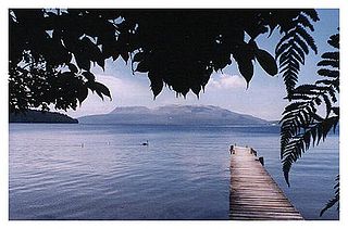
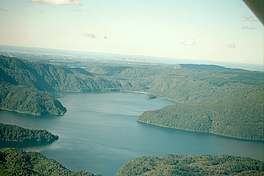
Lake Tarawera is the largest of a series of lakes which surround the volcano Mount Tarawera in the North Island of New Zealand. Like the mountain, it lies within the Ōkataina Caldera. It is located 18 kilometres (11 mi) to the east of Rotorua, and beneath the peaks of the Tarawera massif i.e. Wahanga, Ruawahia, Tarawera and Koa. Tarawera means "Burnt Spear", named by a visiting hunter who left his bird spears in a hut and on returning the following season found that both his spears and hut had been turned to ashes.

Lake Rotorua is the second largest lake in the North Island of New Zealand by surface area, and covers 79.8 km2. With a mean depth of only 10 metres it is considerably smaller than nearby Lake Tarawera in terms of volume of water. It is located within the Rotorua Caldera in the Bay of Plenty Region.

The North Island Volcanic Plateau is a volcanic plateau covering much of central North Island of New Zealand with volcanoes, lava plateaus, and crater lakes. It contains the Taupō caldera complex, Ōkataina caldera complex and Tongariro Volcanic Centre resulting in it being currently the most frequently active and productive area of silicic volcanism on Earth. New Zealand is part of the Pacific Ring of Fire.

Lake Rotoiti is a lake in the Bay of Plenty region of New Zealand. It is the northwesternmost in a chain of lakes formed within the Okataina Caldera. The lake is close to the northern shore of its more famous neighbour, Lake Rotorua, and is connected to it via the Ohau Channel. It drains to the Kaituna River, which flows into the Bay of Plenty near Maketu.
Ngāti Rangitihi is a Māori iwi of New Zealand, located in the Bay of Plenty.
The region around the city of Rotorua, in New Zealand's North Island, contains several lakes which have a total area of about 250 square kilometres. The term Rotorua lakes is ambiguous as it has been used historically for a New Zealand administrative area. From biggest to smallest, these are Lake Rotorua, Lake Tarawera, Lake Rotoiti, Lake Rotomā, Lake Okataina, Lake Rotoehu, Lake Rotomahana, Lake Rerewhakaaitu, Lake Rotokākahi, Lake Okareka and Lake Tikitapu. There are also smaller lakes including: Lake Okaro, Lake Rotokawa, Lake Rotokawau and Lake Rotongata. Most of the lakes have formed due to volcanic activity and some have current geothermal activity. The region is part of the Taupō Volcanic Zone, the world's most active area of explosive silicic volcanic activity in geologically recent time.

The 1886 eruption of Mount Tarawera was a violent volcanic eruption that occurred in the early hours of 10 June 1886 at Mount Tarawera, near Rotorua on New Zealand's North Island. The eruption reached an estimated volcanic explosivity index (VEI) of 5 and killed an estimated 120 people, making it the largest and deadliest in New Zealand during the past 500 years, a period that includes the entirety of European history in New Zealand.

Lake Rotokawau is a small volcanic lake 4.1 km (2.5 mi) east of Lake Rotorua in the Bay of Plenty region of New Zealand's North Island. The name is also used for lakes in the Kaipara District, Chatham Islands, on Aupouri Peninsula and near Lake Waikare in Waikato. Access is via Lake Rotokawau Road, from SH30 at Tikitere. The lake is owned and managed by Ngāti Rangiteaorere.
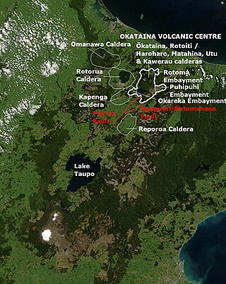
The Kapenga Caldera in New Zealand’s Taupō Volcanic Zone lies in a low land area immediately south of Lake Rotorua through the Hemo Gap in the Rotorua Caldera rim. At some time more than 60,000 years ago Lake Rotorua drained through the Hemo Gap and some of the Kapenga Caldera floor was likely occupied by a lake, that has been called Kapenga.
Ōkataina Caldera is a volcanic caldera and its associated volcanoes located in Taupō Volcanic Zone of New Zealand's North Island. It has several actual or postulated sub calderas. The Ōkataina Caldera is just east of the smaller separate Rotorua Caldera and southwest of the much smaller Rotomā Embayment which is usually regarded as an associated volcano. It shows high rates of explosive rhyolitic volcanism although its last eruption was basaltic. The postulated Haroharo Caldera contained within it has sometimes been described in almost interchangeable terms with the Ōkataina Caldera or volcanic complex or centre and by other authors as a separate complex defined by gravitational and magnetic features.. Since 2010 other terms such as the Haroharo vent alignment, Utu Caldera, Matahina Caldera, Rotoiti Caldera and a postulated Kawerau Caldera are often used, rather than a Haroharo Caldera classification.
The Ōkāreka Embayment is a volcanic feature in Taupo Volcanic Zone of New Zealand. Its most significant recent volcanic eruption was about 15,700 years ago and this deposited the widespread Rotorua tephra that reached beyond Auckland.

The Tikitere Graben is a intra-rift graben in the North Island of New Zealand that contains the Ohau Channel, which drains Lake Rotorua into Lake Rotoiti with a minimal drop between the lakes.