Nawab, also spelled Nawaab, Navaab, Navab, Nowab, Nabob, Nawaabshah, Nawabshah or Nobab, is a royal title indicating a sovereign ruler, often of a South Asian state, in many ways comparable to the western title of Prince. The relationship of a Nawab to the Emperor of India has been compared to that of the Kings of Saxony to the German Emperor. In earlier times the title was ratified and bestowed by the reigning Mughal emperor to semi-autonomous Muslim rulers of subdivisions or princely states in the Indian subcontinent loyal to the Mughal Empire, for example the Nawabs of Bengal.

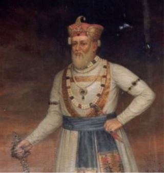
Shuja-ud-Daula was the third Nawab of Oudh and the Vizier of Delhi from 5 October 1754 to 26 January 1775.
Saharanpur is a city and a municipal corporation in Uttar Pradesh, India. It is also the administrative headquarters of Saharanpur district.

Rohillas are a mixed Indian community of Pashtun heritage, historically found in Rohilkhand, a region in the state of Uttar Pradesh, India. It forms the largest Pashtun diaspora community in India, and has given its name to the Rohilkhand region. The Rohilla military chiefs settled in this region of northern India in the 1720s, the first of whom was Ali Mohammed Khan.

The Battle of Buxar was fought between 22 and 23 October 1764, between the forces of the British East India Company, under the command of Major Hector Munro, and the combined armies of Balwant Singh, Maharaja of the Banaras State; Mir Qasim, Nawab of Bengal; Shuja-ud-Daula, Nawab of Awadh; and Shah Alam II, Emperor of the Mughal Empire.

The Bareilly district belongs to the state Uttar Pradesh in northern India. Its capital is Bareilly city and it is divided in six administrative division or tehsils: Aonla, Baheri, Bareilly city, Faridpur, Mirganj, and Nawabganj. The Bareilly district is a part of the Bareilly Division and occupies an area of 4120 km2 with a population of 4,448,359 people according to the census of 2011.

Bijnor district is one of the 75 districts in the state of Uttar Pradesh in India. Bijnor city is the district headquarters. The government of Uttar Pradesh seeks its inclusion in National Capital Region (NCR) due to its close proximity to NCT of Delhi.

Saharanpur district is the northernmost of the districts of Uttar Pradesh state, India. Bordering the states of Haryana, Himachal Pradesh and Uttarakhand, and close to the foothills of Shivalik range, it lies in the northern part of the Doab region.
Rajaji National Park is a national park and tiger reserve in the Indian state of Uttarakhand. that encompasses the Shivaliks, near the foothills of the Himalayas. It covers 820 km2 (320 sq mi) and is included in three districts of Uttarakhand—Haridwar, Dehradun and Pauri Garhwal. In 1983, three wildlife sanctuaries in the area were merged into one.

Haridwar district also spelled as Hardwar is part of Uttarakhand, India.It lies in doab region where people speak khari boli. It is headquartered at Haridwar which is also its largest city. The district is ringed by the districts Dehradun in the north and east, Pauri Garhwal in the east and the Uttar Pradesh districts of Muzaffarnagar and Bijnor in the south and Saharanpur in the west.

Najibabad is a town in the Bijnor district of the Indian state of Uttar Pradesh, located near the city of Bijnor. It is a major industrial centre and has national transport links via rail and roadways such as NH 119 and NH 74.

Najib ad-Dawlah, also known as Najib Khan Yousafzai, was a Rohilla Yousafzai Afghan who earlier served as a Mughal serviceman but later deserted the cause of the Mughals and joined Ahmad Shah Abdali in 1757 in his attack on Delhi. He was also a House Chief of Rohilkhand, and in the 1740s founded the city of Najibabad in Bijnor district, India. He was instrumental in winning the Third Battle of Panipat.
Auraiya is a city and a municipal board in Auraiya district in the state of Uttar Pradesh, India. NH 19 passes through the center of the town. Phaphund is the nearest railway station and Saifai Airstrip the nearest aviation facility, having limited private use. Etawah Safari Park is the nearest lion safari park. The nearest commercial airport is Kanpur Airport. Before becoming the district headquarters, it was the tehsil headquarters of Etawah district. This district is under Kanpur Mandal. [1] [2] [3] This is the heroic place of Sengar Rajputs. Sengar dynasty Kanardhani Maharajadhiraj Vishok Dev was married to Devkala, sister of Maharaja Jaichand Gaharwar (Rathore) of Kannauj. He had received this entire area in dowry. The famous Devkali Temple here was also built by him in the name of his wife Devkali. There are many famous villages of Kshatriya in which Ayana, Bhartaul, Jaswantpur, Bhurepur Kalan, Bhurepur Khurd, Sikharna, Fareha, Anepur, Senganpur, Barbatpur, Roshangpur, Manpur, Bhaupur, keontra, Phaphund, Aseva,Shahbadiya are very famous villages.
Kiratpur, also known as Basi Kiratpur, is a town and a Municipal Board in Bijnor district of Uttar Pradesh.

The Nawab of Awadh or Nawab of Oudh was the title of the rulers of Kingdom of Awadh in northern India during the 18th and 19th centuries. The Nawabs of Awadh belonged to an Iranian dynasty of Sayyid origin from Nishapur, Iran. In 1724, Nawab Sa'adat Khan established the Kingdom of Awadh with their capital in Faizabad and Lucknow.

The First Rohilla War of 1773–1774 was a punitive campaign by Shuja-ud-Daula, Nawab of Awadh on the behalf of Mughal Emperor, against the Rohillas, Indian descendants of Afghan highlanders settled in Rohilkhand, northern India. The Nawab was supported by troops of the British East India Company, in a successful campaign brought about by the Rohillas reneging on a debt to the Nawab.
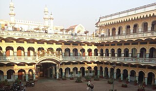
Nawab Faizullah Ali Khan was the first Nawab of Rampur. The princely state of Rampur was set up in year 1774, after the First Rohilla War, by the dismemberment of the Rohilla Kingdom of Rohilkhand. Faizullah Khan, the only surviving heir of Ali Mohammed Khan and opponent of the forces of Awadh and the British East India Company in the war, was installed as ruler of what was the newly created Rampur State. It bordered the Maratha Empire to the south, making it a strategic point. Under tutelage of the East India Company, Faizullah Khan ruled peacefully for 20 years. The capital Rampur was founded, and the Raza Library collection gathered.

Raja Tikait Rai "Bahadur" was the Diwan of Awadh from 1791 - 1796 CE in the regime of Asaf-ud-Daula. He belonged to North Indian Kayastha community of India.
According to the epic Mahābhārata, Bareilly region (Panchala) is said to be the birthplace of Draupadi, who was also referred to as 'Panchali' by Kṛṣṇā. When Yudhishthira becomes the king of Hastinapura at the end of the Mahābhārata, Draupadi becomes his queen. The folklore says that Gautama Buddha had once visited the ancient fortress city of Ahicchattra in Bareilly. The Jain Tirthankara Parshva is said to have attained Kaivalya at Ahichhatra.

The Oudh State was a Mughal subah, then an independent kingdom, and lastly a princely state in the Awadh region of North India until its annexation by the British in 1856. The name Oudh, now obsolete, was once the anglicized name of the state, also written historically as Oudhe.


