
The South Tynedale Railway is a preserved, 2 ft narrow gauge heritage railway in Northern England and at 875 feet (267 m) is England's second highest narrow gauge railway after the Lynton and Barnstaple Railway in north Devon. The South Tynedale line runs from Alston in Cumbria, down the South Tyne Valley, via Gilderdale, Kirkhaugh and Lintley, then across the South Tyne, Gilderdale and Whitley Viaducts to Slaggyford in Northumberland.

Haltwhistle is a market town and civil parish in Northumberland, England, 23 miles east of Carlisle and 37 miles west of Newcastle upon Tyne. It had a population of 3,811 at the 2011 Census.

The Royal Border Bridge spans the River Tweed between Berwick-upon-Tweed and Tweedmouth in Northumberland, England. It is a Grade I listed railway viaduct built between 1847 and 1850, when it was opened by Queen Victoria. It was designed by Robert Stephenson. It was built for the York, Newcastle and Berwick Railway and is still in regular use today, as part of the East Coast Main Line. Despite its name, the bridge does not in fact span the border between England and Scotland, which is approximately three miles further north.

Haltwhistle is a railway station on the Tyne Valley Line, which runs between Newcastle and Carlisle via Hexham. The station, situated 22 miles 66 chains east of Carlisle, serves the market town of Haltwhistle in Northumberland, England. It is owned by Network Rail and managed by Northern Trains.

The Ouse Valley Viaduct carries the Brighton Main Line over the River Ouse in Sussex. It is located to the north of Haywards Heath and the south of Balcombe. Known for its ornate design, the structure has been described as "probably the most elegant viaduct in Britain."
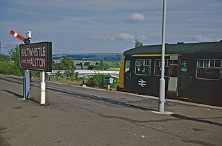
The Alston Line was a 13-mile (21 km) single-track branch line, which linked Haltwhistle in Northumberland with Alston in Cumbria.

Victoria Viaduct, originally known as the Victoria Bridge, is a stone arch rail viaduct spanning the River Wear about 1 mile (1.6 km) south-east of Washington in the City of Sunderland North East England. It was built as part of the Durham Junction Railway under the supervision of Thomas Elliot Harrison.

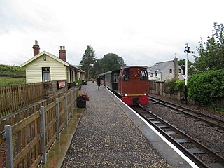
Alston is a heritage railway station on the South Tynedale Railway. The station, situated 13 miles (21 km) south of Haltwhistle, is in the market town of Alston, Eden in Cumbria, England.

Lambley, formerly known as Harper Town, is a village and former civil parish, now in the parish of Coanwood, in Northumberland, England about four miles southwest of Haltwhistle. The village lies adjacent to the River South Tyne. In 1951 the parish had a population of 298. The place name Lambley refers to the "pasture of lambs". Lambley used to be the site of a small convent of Benedictine Nuns, founded by Adam de Tindale and Heloise, his wife, in the 12th century. The Scots led by William Wallace devastated it in 1296 [Rowland gives 1297]. However it was restored and one William Tynedale was ordained priest to the nunnery in about 1508 – most likely not William Tyndale, the reformer, as once believed but another man of the same name. At the time of the suppression of religious houses by Henry VIII, the nunnery contained six inmates. Nothing now remains but the bell from the nunnery, which hangs in the church, and a few carved stones. The village lies in the Midgeholme Coalfield and there are reserves of good-quality coal remaining.

The Tyne Valley Line is a 58-mile (93 km) route, linking Newcastle upon Tyne with Hexham and Carlisle, England. The line follows the course of the River Tyne through Tyne and Wear and Northumberland. Five stations and two viaducts on the route are listed structures.

The River Irwell Railway Bridge was built for the Liverpool & Manchester Railway (L&MR), the world's first passenger railway which used only steam locomotives and operated as a scheduled service, near Water Street in Manchester, England. The stone railway bridge, built in 1830 by George Stephenson, was part of Liverpool Road railway station. The bridge was designated a Grade I listed building on 19 June 1988.
Featherstone Park was a railway station on the Alston Branch Line, which ran between Haltwhistle and Alston. The station, situated 3 miles (5 km) south-west of Haltwhistle, served the villages of Featherstone and Rowfoot in Northumberland.

Lambley was a railway station on the Alston Branch Line, which ran between Haltwhistle and Alston. The station, situated 4+3⁄4 miles (8 km) south-west of Haltwhistle, served the village of Lambley in Northumberland.

The Newcastle & Carlisle Railway (N&CR) was an English railway company formed in 1825 that built a line from Newcastle upon Tyne on Britain's east coast, to Carlisle, on the west coast. The railway began operating mineral trains in 1834 between Blaydon and Hexham, and passengers were carried for the first time the following year. The rest of the line opened in stages, completing a through route between Carlisle and Gateshead, south of the River Tyne in 1837. The directors repeatedly changed their intentions for the route at the eastern end of the line, but finally a line was opened from Scotswood to a Newcastle terminal in 1839. That line was extended twice, reaching the new Newcastle Central Station in 1851.

Alston Arches Viaduct, also known as Haltwhistle Viaduct, is a stone bridge across the River South Tyne at Haltwhistle in Northumberland, England.

Stonequarry Creek railway viaduct is a heritage-listed railway viaduct over the Stonequarry Creek located on the Main Southern railway in the south-western Sydney town of Picton in the Wollondilly Shire local government area of New South Wales, Australia. It was designed by John Whitton as the Engineer-in-Chief for Railways and was built from 1863 to 1867 by Murnin and Brown. It is also known as Stonequarry Creek Railway Viaduct and Picton railway viaduct over Stonequarry Creek. The property is owned by Transport Asset Holding Entity, an agency of the Government of New South Wales. It was added to the New South Wales State Heritage Register on 2 April 1999.

The Bowenfels rail viaducts are a series of heritage-listed railway viaducts and railway bridges over Farmers Creek on the Main Western Line at Bowenfels, in the Central West region of New South Wales, Australia. It was designed in two stages, by John Whitton as the Engineer-in-Chief for Railways, in 1870; and by engineering staff of New South Wales Government Railways in 1921; and was built from 1870 to 1921. It is also known as Farmers Creek viaducts. The property is owned by Transport Asset Holding Entity, an agency of the Government of New South Wales. It was added to the New South Wales State Heritage Register on 2 April 1999. The viaduct are located approximately 159 kilometres (99 mi) west of Central railway station.

Coanwood was a railway station on the Alston Branch Line, which ran between Haltwhistle and Alston. The station, situated 4 miles (6 km) south-west of Haltwhistle, served the village of Coanwood in Northumberland.
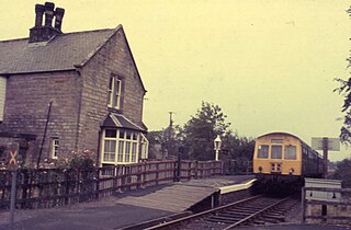
Slaggyford was historically a railway station on the Alston Line, which ran between Haltwhistle and Alston. The station served the village of Slaggyford in Northumberland.

The Chirk Viaduct is a Grade II* listed railway viaduct over the River Ceiriog between England and Wales. The viaduct carries the Shrewsbury–Chester line from the Welsh town of Chirk in historic Denbighshire from the north to the English village of Chirk Bank in Weston Rhyn, Shropshire to the south. To the east, the Chirk Aqueduct lies parallel to the railway viaduct.


