Latchmere Recreation Ground, Kingston upon Thames

Last updated

Latchmere Recreation Ground
Latchmere Recreation Ground (geograph 2547315).jpg
Latchmere Recreation Ground
Latchmere Recreation Ground, Kingston upon Thames
TypePublic open space
Location Canbury, Kingston upon Thames
Coordinates 51°25′23″N0°17′42″W / 51.423°N 0.295°W / 51.423; -0.295 Coordinates: 51°25′23″N0°17′42″W / 51.423°N 0.295°W / 51.423; -0.295
Area3.6 hectares (8.9 acres) [1]
Created1901
Operated by Royal Borough of Kingston upon Thames
OpenAll year

Latchmere Recreation Ground is a public open space with playing fields and a children's playground in the north of the Royal Borough of Kingston upon Thames.

Contents

Location

Latchmere Recreation Ground is located in the Tudor ward of the Canbury area of Kingston, on flat ground at the bottom of the hill that rises within nearby Richmond Park less than 400m to the east. The River Thames and Canbury Gardens lie approximately half a kilometre to the west and Ham Common a similar distance to the north. It is set in a suburban residential area bounded by Latchmere Road to the south, Latchmere Lane to the west, Aldersbrook Drive to the east and the rear of houses on Tudor Drive to the north.

Description

Latchmere Recreation Ground is a flat, quadrilateral-shaped, area mostly laid out to managed sports field turf. The space is enclosed within a metal fence with the main pedestrian and maintenance vehicle access gates at the south-western corner at the junction of Latchmere Road and Latchmere Lane. Other pedestrian gates are located at the south-east and north-west corners and mid-way along the western side from which a gravel path leads to the south-east corner. Another pedestrian gate provides access from opposite Latchmere Infant School mid-way along the southern side and another from the end of Cranleigh Gardens on the north-east. The traversing footpath and the perimeter are lined with rows of trees which merge with a small wooded area along the northern border. The eastern border was originally defined by the course of the Latchmere Stream, since culverted. [2] [3] [4]

The playing field space is usually laid out to five football pitches overlapped by a central cricket pitch which is less frequently used. A modern children's playground occupies the south east corner opposite Latchmere Primary School and St Agatha's RC Primary School to the south. A small pavilion near to the playground was converted for general community use but was declared unsafe and demolished in 2008. Plans to replace it with a two-storey pavilion were eventually rejected in 2011. [5] [6] The concrete base remains, since occupied by two storage containers. [7] An adjacent brick public toilet block, described as "dilapidated" in 2010, remains and has been partially refurbished. [5] [8]

History

The land formed part of the ancient manor of Kingston-Canbury and, until the mid nineteenth-century, was predominately agricultural. The manor was purchased by the Tollemache family in the early 19th-century, returning ownership to the Earl of Dysart's estate centred around Ham House. The Tollemaches sold much of this area of north Kingston and southern Ham for piecemeal housing development during the late 1800s and made provision for recreation grounds in the area. The field that became Latchmere Recreation Ground was used for cricket and a nearby area south of Latchmere Road on the Richmond Road was an athletics and rugby ground before becoming the home of Kingstonian F.C. between 1919 and 1988. Ownership of the Latchmere Recreation Ground was conveyed by William John Manners Tollemache, 9th Earl of Dysart and the Dysart Trustees on 23 February 1904 to the Municipal Borough of Kingston-upon-Thames, "Kingston Corporation", as part of the settlement of the Richmond, Petersham and Ham Open Spaces Act 1902. The land itself, though, remained within and defined part of the southern boundary of Ham Urban District. [3] The indenture contained covenants constraining the use of the land and preventing unrelated building development: [9]

The site was included in 261 acres (106 ha) of southern Ham transferred to the Municipal Borough of Kingston when Ham Urban District was abolished in 1933. [3] [10]

During World War II part of the recreation grounds, as well as nearby Dinton Field, were cultivated for growing vegetables. A high-explosive bomb fell near the site during the Blitz and in 1944 a V-1 flying bomb landed in the recreation ground, damaging nearby Latchmere School. [11] [12]

Uses

Children's football is played regularly on the ground with regular training and matches organised by Kingston Little League Football. [13] A study conducted in 2011 identified a deficit of public playing field facilities in the area close to Kingston town centre, highlighting the relative importance of the site. [14] The adjacent primary schools make use of the field for organised sport and recreation. The ground is used informally by many local residents throughout the year.

Management

The site is currently maintained and managed by Kingston council's outsourced contractor, Idverde via its subsidiary company, Quadrillon Services. [15] [16] A community group, the 'Friends of Latchmere Recreation Ground' (FoLaR), was formed in 2017 to support the use and development of the site. Plans for improving the natural environmental facilities by building a wildlife pond and possibly re-exposing part of the culverted Latchmere Stream have been proposed. [17]

Related Research Articles

<span class="mw-page-title-main">Kingston upon Thames</span> Town in South West London

Kingston upon Thames is a town in the Royal Borough of Kingston upon Thames, southwest London, England. It is situated on the River Thames and 10 miles (16 km) southwest of Charing Cross. It is notable as the ancient market town in which Saxon kings were crowned and today is the administrative centre of the Royal Borough.

Richmond is a town in south-west London, 8.2 miles (13.2 km) west-southwest of Charing Cross. It stands on a meander of the River Thames, and features many parks and open spaces, including Richmond Park, and many protected conservation areas, which include much of Richmond Hill. A specific Act of Parliament protects the scenic view of the River Thames from Richmond.

<span class="mw-page-title-main">Whitton, London</span> Human settlement in England

Whitton is an area in the London Borough of Richmond upon Thames, England. Historically, the boundaries of Whitton were the north-western part of Twickenham manor, bounded internally by the sections of the River Crane and the Duke of Northumberland's River.

The TW postcode area, also known as the Twickenham postcode area, is a group of twenty postcode districts in south-east England, within thirteen post towns. These cover parts of south-west London and north-west Surrey, plus a very small part of Berkshire.

<span class="mw-page-title-main">Ham, London</span> Area of Richmond in London, England

Ham is a suburban district in Richmond, south-west London. It has meadows adjoining the River Thames where the Thames Path National Trail also runs. Most of Ham is in the London Borough of Richmond upon Thames and, chiefly, within the ward of Ham, Petersham and Richmond Riverside; the rest is in the Royal Borough of Kingston upon Thames. The district has modest convenience shops and amenities, including a petrol station and several pubs, but its commerce is subsidiary to the nearby regional-level economic centre of Kingston upon Thames.

<span class="mw-page-title-main">Parks and open spaces in the Royal Borough of Kingston upon Thames</span>

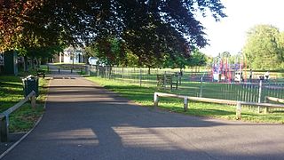
The Royal Borough of Kingston upon Thames is located along a stretch of the River Thames where the Hogsmill River joins the former at the town of Kingston. The Borough contains over 30 parks, 24 playgrounds, sports grounds and open spaces. There are also over 20 allotments sites which are either self-managed or run by the local council. An assessment conducted in 2006 identified 165 hectares of park and 340 hectares of other open spaces in the borough.

<span class="mw-page-title-main">Tollemache family</span>

The Tollemache family is an English noble family, originally from Suffolk. The family's surname is pronounced TOL-mash.

<span class="mw-page-title-main">Steven's Eyot</span> Island in the River Thames

Steven's Eyot is a narrow ait (island) in the River Thames in the Royal Borough of Kingston upon Thames, London, England, on the non-tidal reach above Teddington Lock.

<span class="mw-page-title-main">Hammerton's Ferry</span> Pedestrian and cycle ferry service across the River Thames

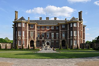
Hammerton's Ferry is a pedestrian and cycle ferry service across the River Thames in the London Borough of Richmond upon Thames, London, England. The ferry links the river's northern bank near Marble Hill House in Twickenham with its southern bank near Ham House in Ham. It is one of only four remaining ferry routes in London not to be replaced by a bridge or tunnel.

<span class="mw-page-title-main">William Tollemache, 9th Earl of Dysart</span>

William John Manners Tollemache, 9th Earl of Dysart DL in the Peerage of Scotland, was also a Baronet (cr.1793) in the Baronetage of Great Britain, Lord Lieutenant of Rutland (1881–1906), and Justice of the Peace for Leicestershire and Lincolnshire.

<span class="mw-page-title-main">Latchmere House</span> Building in London, UK, used as a prison and now flats.

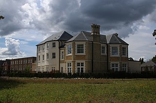
Latchmere House is a building and grounds southeast of Ham Common in Ham, in the London Borough of Richmond upon Thames, in south west London, England. The southern part of the site lies in the Royal Borough of Kingston upon Thames.

<span class="mw-page-title-main">Canbury Gardens</span> Park in Kingston upon Thames, London

Canbury Gardens is a public space in the Canbury district of Kingston upon Thames, along the Lower Ham Road, covering 14½ acres area between the road and the towpath along the River Thames, downstream from Kingston Railway Bridge.

<span class="mw-page-title-main">Sudbrook (stream)</span> River in England

Sudbrook and its tributary, the Latchmere stream, are north-flowing streams in London, England, that drain northern Kingston upon Thames and the eastern extreme of Ham following a meander scar in a terrace; the upper part of the Sudbrook drains a narrow vale in Richmond Park's southern corner into the tidal Thames.

<span class="mw-page-title-main">North Sheen Recreation Ground</span> Football club

North Sheen Recreation Ground, in Dancer Road, Kew, Richmond, London, is a recreation area and the home of Kew Park Rangers Football Club.

<span class="mw-page-title-main">Canbury</span> District in Kingston upon Thames, London

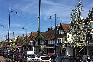
Canbury is a district of the northern part of Kingston upon Thames that takes its name from the historic manor that covered the area. Modern Canbury comprises two electoral wards in the constituency of Richmond Park; Canbury Ward to the south and Tudor Ward to the north.

<span class="mw-page-title-main">Ham Common, London</span>

Ham Common is an area of common land in Ham, London. It is a conservation area in, and managed by, the London Borough of Richmond upon Thames. It comprises 48.69 hectares, the second largest area of common land in the borough, 2 acres (0.81 ha) smaller than Barnes Common. It is divided into two distinct habitats, grassland and woodland, separated by the A307, Upper Ham Road. It is an area of ecological, historical and recreational interest, designated a Local Nature Reserve.

<span class="mw-page-title-main">Lyonel Tollemache</span> English Baronet

Sir Lyonel Felix Carteret Eugene Tollemache, 4th Baronet was an English landowner.

<span class="mw-page-title-main">Radnor Gardens</span>

Radnor Gardens is a small public riverside garden and recreation ground in Strawberry Hill, south of Twickenham in the London Borough of Richmond upon Thames. It has a First World War memorial, a grass area, a bowling green and a children's playground.

<span class="mw-page-title-main">Latchmere Recreation Ground, Battersea</span> Park in Wandsworth, London

Latchmere Recreation Ground or Latchmere Park is a public open space with a children's playground in Battersea in the London Borough of Wandsworth. It is located approximately 300 metres (330 yd) south of the far larger Battersea Park and the River Thames beyond. It is bounded by Burns Road to the south and Reform Street to the east and north. The former Latchmere School site, converted to housing in 1996, forms the eastern boundary.

References

  1. "Latchmere Recreation Ground, Kingston" . Retrieved 21 January 2020.
  2. Surrey VI.SE (includes: Ham; Kingston upon Thames; Twickenham St Mary the Virgin.) (Map) (Revised: 1893 to 1895 ed.). 1:10,560. Ordnance Survey Maps - Six-inch England and Wales, 1842-1952. National Library of Scotland. 1899.
  3. 1 2 3 Surrey VI.SE (includes: Ham; Kingston upon Thames; Twickenham St Mary the Virgin.) (Map) (Revised: 1911 to 1912 ed.). 1:10,560. Ordnance Survey Maps - Six-inch England and Wales, 1842-1952. National Library of Scotland. 1920.
  4. Surrey VI.SE (includes: Ham; Kingston upon Thames; Twickenham St Mary the Virgin.) (Map) (Revised: 1938 ed.). 1:10,560. Ordnance Survey Maps - Six-inch England and Wales, 1842-1952. National Library of Scotland. 1946.
  5. 1 2 "Planning consultation (10/12045/FUL): Recreation Ground, Latchmere Road, Kingston upon Thames". Royal Borough of Kingston upon Thames. 24 March 2010.
  6. Barnes, Tom (10 December 2011). "Kingston council u-turn over Latchmere pavilion plans". Sutton & Croydon Guardian.
  7. "Committee Agenda Items - Kingston Council 08/12544/FUL". Royal Borough of Kingston upon Thames. 15 January 2009.
  8. Latchmere Rec. Ground Public Toilet Regeneration Project. 4 May 2017.
  9. "History". Friends of Latchmere Recreation Ground. Retrieved 27 January 2020.
  10. Great Britain Historical GIS / University of Portsmouth, Ham Urban District . Retrieved 2009-10-29.
  11. "High Explosive Bomb at Latchmere Road". Bomb Sight, mapping the WW2 bomb census. Retrieved 27 January 2020.
  12. "History". Latchmere School. Retrieved 21 January 2020.
  13. "About Kingston Little League" . Retrieved 21 January 2020.
  14. O'Brien, Michael; Rodriguez, Michael; Shaw, Adrian; Wyant, Christopher (28 April 2011), Playing pitch provision in the Royal Borough of Kingston Upon Thames (PDF) (thesis), Worcester Polytechnic Institute, Worcester, MA
  15. "About Us | The Royal Borough of Kingston Upon Thames | idverde".
  16. "Green spaces strategy 2015 to 2021". Royal Borough of Kingston upon Thames. Archived from the original on 31 October 2020. Retrieved 20 January 2020.
  17. "Latchmere Recreation Ground Wildlife Pond" (PDF). Royal Borough of Kingston upon Thames . Retrieved 22 January 2020.