Whitley County is a county in the U.S. state of Kentucky. As of the 2010 census, the population was 35,637. The county seat is at Williamsburg, though the largest city is Corbin, and the county's District Court sits in both cities.

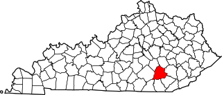
Laurel County is a county in the U.S. state of Kentucky. As of the 2010 census, the population was 58,849. Its county seat is London.

Pineville is a home rule-class city in Bell County, Kentucky, United States. It is the seat of its county. The population was 1,732 as of the 2010 census. It is located on a small strip of land between the Cumberland River and Pine Mountain.
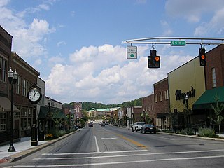
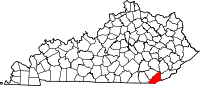
London is a home rule-class city in Laurel County, Kentucky, in the United States. It is the seat of its county. The population was 7,993 at the time of the 2010 U.S. census. London, Kentucky, is the second-largest city named London in the United States and the fourth-largest in the world. It is part of the London, Kentucky micropolitan area. Of the seventeen micropolitan areas in Kentucky, London is the largest; the London micropolitan area's 2010 Census population was 126,369. London is also home to the annual World Chicken Festival that celebrates the life of Colonel Sanders and features the world's largest skillet.

Somerset Community College (SCC), located in Somerset, Kentucky, is one of 16 two-year, open-admissions colleges of the Kentucky Community and Technical College System (KCTCS). The college offers academic, general education, and technical curricula leading to certificates, diplomas, and associate's degrees. Somerset Community College is accredited by the Commission on Colleges of the Southern Association of Colleges and Schools (SACS).

This is a list of properties and historic districts in Kentucky that are listed on the National Register of Historic Places. There are listings in all of Kentucky's 120 counties.

The Eastern Kentucky Coalfield is part of the Central Appalachian bituminous coalfield, including all or parts of 30 Kentucky counties and adjoining areas in Ohio, West Virginia, Virginia and Tennessee. It covers an area from the Allegheny Mountains in the east across the Cumberland Plateau to the Pottsville Escarpment in the west. The region is known for its coal mining; most family farms in the region have disappeared since the introduction of surface mining in the 1940s and 1950s.

Pine Mountain State Resort Park is a Kentucky state park located in Bell County, Kentucky, United States. The park opened in 1924 as Kentucky's first state park. Each spring, the park hosts the annual Kentucky Mountain Laurel Festival, as it has since 1933. A portion of the park is also a legally dedicated nature preserve by the Office of Kentucky Nature Preserves.
The Kentucky High School Athletic Association boys' and girls' state basketball championships are single elimination tournaments held each March featuring 16 high schools. Colloquially known as the Sweet Sixteen, the tournament takes place over four days at downtown Lexington's Rupp Arena for the boys and Highland Heights' BB&T Arena on the campus of Northern Kentucky University for the girls.
Interstate 75 (I-75) runs from near Williamsburg to Covington by way of Lexington in the U.S. state of Kentucky. I-75 enters the Cumberland Plateau region from Tennessee, then descends into the Bluegrass region through the Pottsville Escarpment before crossing the Ohio River into Ohio. I-75 follows along the U.S. Route 25 corridor for the entire length of Kentucky.

Knox County is a county located near the southeastern corner of the U.S. state of Kentucky. As of the 2010 census, the population was 31,883. Its county seat is Barbourville. The county is named for General Henry Knox.

This is a list of the National Register of Historic Places listings in Bell County, Kentucky.
This is a list of the National Register of Historic Places listings in Laurel County, Kentucky.
WVTN-LP is a low-powered television station that is licensed to and serving Corbin, Kentucky. The station is owned by Victory Training School Corporation, and is broadcasting religious programming. It is an independent station, but it also shows programming from the Daystar Television Network from 9 p.m. to 10 a.m. ET. Its transmitter is located in southwestern Laurel County along Kentucky Route 312 off of Interstate 75 northwest of Corbin. WVTN-LP shares their studios and broadcasting facilities with WVCT FM Radio, and they are located at 968 West City Dam Road in Keavy, Kentucky.
Kentucky Route 190 (KY 190) is a 21.5-mile-long (34.6 km) state highway in the U.S. state of Kentucky. The highway travels through rural areas of Bell County.
Kentucky Route 221 (KY 221) is a 42.5-mile-long (68.4 km) state highway in the U.S. state of Kentucky. The highway connects mostly rural areas of Bell, Harlan, Perry, and Leslie counties with the Daniel Boone National Forest.