Territory
The nature reserve, whose soil consists mainly of tuff, is spread on the slopes of the Latium Volcano and occupies three little valley floors (in Italian fosso, meaning "ditch"): from north to south Fosso del Ciuccio, Fosso dell'Acqua Acetosa and Fosso del Vallerano. The first two streams reach the Vallerano downstream of the hamlet il Castellaccio (after Via Cristoforo Colombo), a few hundred meters before it flows into the Tiber. [2]
The first ditch, heavily urbanized, is the axis around which the Laurentino 38 ring road develops. It is partially equipped for leisure.
In the second ditch the use of the territory is varied, since there are both residential and agricultural areas. Its peculiarity derives from the presence, in the eastern part, of the Acqua Acetosa Ostiense archeological area and, at the south-eastern edge, of the San Paolo mineral water source.
The third ditch shows the characteristics of an agricultural valley and has kept the appearance conferred by the hydraulic reclamation carried out in the 1930s.
Fauna
In the freshwater streams that cross the Reserve live the river crab (Potamon fluviatile), the frog (Rana), the toad (Bufo bufo) and the newt (Triturus). Among the reptiles, there is the grass snake (Natrix natrix), as well as the green whip snake (Hierophis viridiflavus), the lizard (Lacertilia), the gecko (Tarentola mauritanica). The nocturnal fauna includes Foxes (Vulpes vulpes), Common pipistrelles (Pipistrellus pipistrellus), Crested porcupines (Hystrix cristata) and Hedgehogs (Erinaceus europaeus). Among the raptors, which often nest in the numerous farmhouses of the Reserve, there are the kestrel (Falco tinnunculus), the little owl (Athene noctua) and the peregrine falcon (Falco peregrinus). Finally, the Reserve hosts several species of birds, including the grey heron (Ardea cinerea), the common moorhen (Gallinula chloropus), the hoopoe (Upupa epops), the nightingale (Luscinia megarhynchos) and the common pheasant (Phasianus colchicus). The presence of the barn owl (Tyto alba) has been signaled.
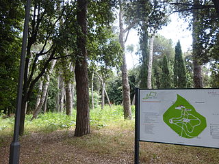
Places of interest
The name Acqua Acetosa (or Acquacetosa or Acqua Cetosa) is due to the presence of the ditch of Acqua Acetosa, a tributary stream of the Vallerano, in turn a left tributary of the Tiber, otherwise known as Acqua Acetosa Ostiense, to distinguish it from another stream with the same name in the quarter Parioli.
Roughly at kilometer 8 of the Via Laurentina there is a source of sulfur mineral water. [3] The source, known to the ancient Romans, was probably used for therapeutic purposes. [4] This water was sold by street vendors known as Acquacetosari. In 1937 a plant for the bottling and sale of the water was installed; [5] the plant, called "Fonte S. Paolo", is currently closed sine die, due to pollution of the acquifer.
Probably this source was already used in protohistoric times, since a settlement – maybe the ancient Tellenae – developed on the plateau overlooking the ditch and the source of Acqua Acetosa. In 1976 the village and the nearby necropolis were protected with the establishment of the archaeological area of Acqua Acetosa, which however is not part of the Nature Reserve.
Issues
The area included in the Reserve is one of the smallest (152 hectares, then increased up to 273) and the most degraded in the Province of Rome. Biodiversity is reduced to just few floral and faunal species, mainly anthropophilic. The agricultural areas are those that maintain an appearance more similar to that preceding the massive building expansion.
As for the archaeological site, this is closed to the public – although it falls within the redevelopment area of the Reserve – since it is under the exclusive control of the Archaeological Superintendence of Rome. This patch of land of a few hectares is actually a crucial knot to untie for a coherent development of the Reserve, since, in addition to Roman antiquities, it includes the 17th-century casale of San Sisto, the old bottling plant of Fonte San Paolo, the Judicial Deposit and an unofficial landfill.

The Aurelian Walls are a line of city walls built between 271 AD and 275 AD in Rome, Italy, during the reign of the Roman Emperor Aurelian. They superseded the earlier Servian Wall built during the 4th century BC.

Monte Soratte is a mountain ridge in the Metropolitan City of Rome, central Italy. It is a narrow, isolated limestone ridge with a length of 5.5 km (3.4 mi) and six peaks. Located some 10 km (6.2 mi) south east of Civita Castellana and c. 45 km (28 mi) north of Rome, it is the sole notable ridge in the Tiber Valley, geologically represents the Meso-cenozoic Tiber ridge. The nearest settlement is the village of Sant'Oreste. Saint Orestes or Edistus, after whom the settlement is named, is said to have been martyred near Monte Soratte.
Testaccio is the 20th rione of Rome, Italy, identified by the initials R. XX, deriving its name from Monte Testaccio. It is located within the Municipio I. Its coat of arms depicts an amphora, referencing to the broken vessels that Monte Testaccio is made of.
The Via Laurentina is the name borne by an ancient and a modern road of Italy, both leading southwards from Rome.
Monte Mario is the hill that rises in the north-west area of Rome (Italy), on the right bank of the Tiber, crossed by the Via Trionfale. It occupies part of Balduina, of the territory of Municipio Roma I, of Municipio Roma XIV and a small portion of Municipio Roma XV of Rome, thus including part of the Quarters Trionfale, Della Vittoria and Primavalle.
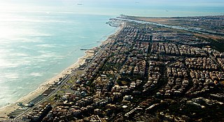
Ostia is a large neighbourhood in the Municipio X of the comune of Rome, Italy, near the ancient port of Rome, which is now a major archaeological site known as Ostia Antica. Ostia is also the only municipio or district of Rome on the Tyrrhenian Sea, and many Romans spend the summer holidays there. It is entirely situated within the municipality of Rome and is the city's seaside resort.
The Aqua Traiana was a 1st-century Roman aqueduct built by Emperor Trajan and inaugurated in 109 AD. It channelled water from sources around Lake Bracciano, 40 km (25 mi) north-west of Rome, to ancient Rome. It joined the earlier Aqua Alsietina to share a common lower route into Rome.

The Nature Reserve of Decima-Malafede is a protected natural area of Lazio, Italy, entirely included in the territory of the Municipality of Rome. It has an area of approximately 6,145 hectares.

Via Cristoforo Colombo is a street in Rome (Italy) that links the historic centre to Ostia. Along most of its route, the street has three lanes for each direction of movement. With its 27 kilometres (17 mi) length it is the longest Italian road among those included within the borders of a single municipality and, in several stretches, the largest in Italy.

Ostiense is the 10th quartiere of Rome, identified by the initials Q. X.

ATAC S.p.A. is an Italian publicly owned company running most of the local public transportation services, paid parking and incentive parking lots in Rome. More specifically, the company handles, on behalf of Roma Capitale Authority, the entire tramway, trolleybus network and metro lines, as well as most of the bus lines in the city. It also operates, on behalf of the Administrative Region of Lazio, three railways: Roma-Civita Castellana-Viterbo, Roma-Giardinetti and Roma-Lido. ATAC S.p.A., with its 2,200-kilometer-wide public transport network, its over 8,500 busses and 70,000 parking stalls, is currently one of the biggest public transportation companies in Europe and the largest in Italy.

Giuliano-Dalmata is the 31st quartiere of Rome, identified by the initials Q. XXXI. Its name refers to the Julian, Istrian and Dalmatian refugees that settled there in the postwar period.

Ponte della Magliana is a motorway bridge in Rome (Italy). It crosses the Tiber between Pian due Torri and Via del Cappellaccio, linking the Quartieri Portuense and Ostiense, respectively, on the right and on the left of the river.
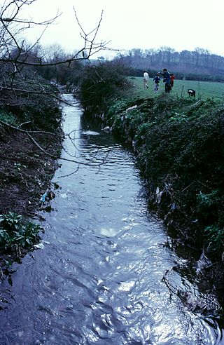
The Almone is a small river of the Ager Romanus, a few miles south of the city of Rome. Today the river is polluted and is channelled to a sewage treatment plant and no longer reaches its natural confluence with the Tiber.

Municipio Roma IX is the ninth administrative subdivision of Rome (Italy).

The zones of Rome are toponymic subdivisions within the area of the Ager Romanus, belonging to the Municipalities of Rome and Fiumicino, Italy.

The Fontana dell'Acqua Acetosa is a fountain in Rome (Italy), located in the flat area with the same name, in the quarter Parioli; at this point the river Tiber forms a deep bend before heading north again. The fountain rises at a lower elevation than the street level, and is therefore accessed via a staircase. In 2003 the Fondo Ambiente Italiano, on the basis of a popular survey, identified it as the monument to which Italians are fondest of.
Villa Glori is a 25-hectare (62-acre) city park in Rome, Italy, within the Municipio II and the quarter Parioli. It is also called Parco della Rimembranza.

The Litorale Romano state nature reserve is a protected area in Lazio (Italy), established by the Ministry of the Environment with Ministerial Decree of March 29, 1996, which includes a large territory of historical-naturalistic interest within the municipalities of Rome and Fiumicino at Tiber Valley.
With its over 17,000 hectares, discontinuously distributed along the Lazio coast between Palidoro and Capocotta, it is the largest protected area overlooking the Mediterranean Sea. Its management is entrusted to the two municipalities in their respective sections of competence.
Corso di Francia, informally called Corso Francia, is a street in the northern area of Rome (Italy). It runs in a south–north direction between the Quarters Parioli and Tor di Quinto and, together with the nearby Via del Foro Italico and Viale Guglielmo Marconi, is the only urban road in the town to overpass the Tiber keeping the same name on both banks.
