Charles B. Wheeler Downtown Airport is a city-owned, public-use airport serving Kansas City, Missouri, United States. Located in Clay County, this facility is included in the National Plan of Integrated Airport Systems, which categorized it as a general aviation reliever airport.

Manhattan Regional Airport in Riley County, Kansas, United States, is the second-busiest commercial airport in Kansas. Owned by the city of Manhattan, Kansas,the airport is located about five miles southwest of downtown Manhattan. American Airlines serves the airport with five daily flights to Chicago O'Hare International Airport and Dallas/Fort Worth International Airport.The airport also accommodates general aviation and charter planes for the military and college sports teams, being conveniently located four miles east of Fort Riley and eight miles southwest of Kansas State University's athletic complex).
Hilton Head Airport is on Hilton Head Island, in Beaufort County, South Carolina, United States. Also known as Hilton Head Island Airport, it is owned by Beaufort County.
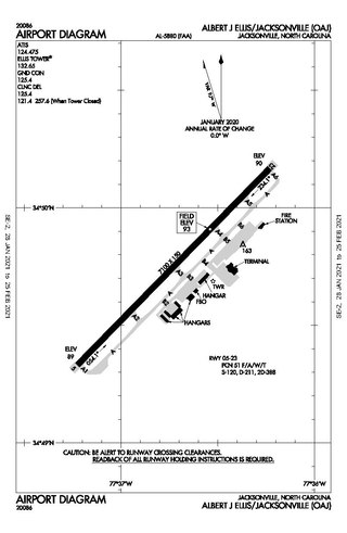
Albert J. Ellis Airport is a county-owned public-use airport in Onslow County, North Carolina, United States. It is located in Richlands, 10 nautical miles (19 km) northwest of the central business district of Jacksonville and Marine Corps Base Camp Lejeune. The airport has a single runway and three gates. Opening on February 15, 1971, the airport is used by general aviation, the military and two commercial airlines, American Eagle and Delta Connection.

Greenville Downtown Airport is an airport three miles east of Greenville, South Carolina, United States. It is owned by the Greenville Airport Commission and is the busiest general aviation airport in South Carolina.
Beaumont Municipal Airport is seven miles west of downtown Beaumont, in Jefferson County, Texas. The National Plan of Integrated Airport Systems for 2017–2021 categorized it as a general aviation facility.

McKinney National Airport, formerly Collin County Regional Airport at McKinney, is a general aviation airport located in McKinney, Texas, United States, about 30 miles north of downtown Dallas.
Tunica Municipal Airport is a public use airport located one nautical mile (2 km) east of the central business district of Tunica, in Tunica County, Mississippi, United States. It is owned by the Tunica County Airport Commission. Also known as Tunica Airport, it should not be confused with the 10 acre privately owned, public use Tunica Airport located 2 nautical miles (4 km) south of the center of town, which has been recently changed to Ralph M Sharpe Airport.

Clarksville–Montgomery County Regional Airport, or simply Outlaw Field, is seven miles northwest of Clarksville, in Montgomery County, Tennessee, United States. It is owned by the city of Clarksville and Montgomery County and is near Fort Campbell.

Renton Municipal Airport is a public use airport located in Renton, a city in King County, Washington, United States. The airport was renamed Clayton Scott Field in 2005 to celebrate the 100th birthday of Clayton Scott. The airport's northern boundary is Lake Washington and the Will Rogers–Wiley Post Memorial Seaplane Base. Renton Airport has a floating dock and a launching ramp for conversion from wheeled landings to water takeoffs and landings.

Eastern West Virginia Regional Airport, also known as Shepherd Field, is a civilian-owned, public use airport located four nautical miles south of the central business district of Martinsburg, a city in Berkeley County, West Virginia, United States. It is owned by the Eastern West Virginia Regional Airport Authority or EWVRAA. This airport is included in the National Plan of Integrated Airport Systems for 2011–2015, in which the Federal Aviation Administration categorized it as a reliever airport.
London-Corbin Airport is in Laurel County, Kentucky, three miles south of London and about 12 miles north of Corbin. The airport is operated by both cities.
Newton City-County Airport is three miles east of Newton, in Harvey County, Kansas. It is owned by the City of Newton and Harvey County.
Council Bluffs Municipal Airport is a public use airport located four nautical miles east of the central business district of Council Bluffs, a city in Pottawattamie County, Iowa, United States. It is owned by Council Bluffs Airport Authority. This airport is included in the National Plan of Integrated Airport Systems for 2011–2015, which categorized it as a general aviation facility.
Benson Municipal Airport Veteran's Field is a city-owned public-use airport located two miles (3 km) west of the central business district of Benson, a city in Swift County, Minnesota, United States.
New Castle Municipal Airport is a small municipal airport located in Union Township, Lawrence County, Pennsylvania serving Lawrence County, Pennsylvania, part of the Pittsburgh metropolitan area. Union Township is an outskirt of New Castle, Pennsylvania hence the name. The airport is located four nautical miles northwest of the central business district of New Castle. The airport is a public-owned airport and is controlled by the Lawrence County Airport Authority.
Pratt Regional Airport is a public airport five miles north of Pratt, in Pratt County, Kansas. Previously known as Pratt Industrial Airport, it is on the site of the former Pratt Army Airfield.
Richmond Municipal Airport is six miles southeast of Richmond near Boston, in Wayne County, Indiana. It is owned by the Richmond Board of Aviation Commissioners. The National Plan of Integrated Airport Systems for 2011–2015 called it a general aviation facility.
Carlisle Airport (Pennsylvania) (IATA: N94, ICAO: None, FAA LID: N94) is a publicly-owned, public use airport located one nautical miles (two mi, three km) southeast of the central business district of Carlisle, a city in Cumberland County, Pennsylvania, United States. This airport is owned and operated by South Middleton Township, Cumberland County, Pennsylvania.
Crandon Municipal Airport, also known as Steve Conway Municipal Airport, is a city owned public use airport located 3 miles (5 km) southwest of the central business district of Crandon, a city in Forest County, Wisconsin, United States. It is included in the Federal Aviation Administration (FAA) National Plan of Integrated Airport Systems for 2021–2025, in which it is categorized as a basic general aviation facility.


