
The geography of Switzerland encompasses the geographical features of Switzerland, a mountainous and landlocked country located in Western and Central Europe. Switzerland's natural landscape is marked by its numerous lakes and mountains. It is surrounded by 5 countries: Austria and Liechtenstein to the east, France to the west, Italy to the south and Germany to the north. Switzerland has a maximum north–south length of 220 kilometres (140 mi) and an east–west length of about 350 kilometres (220 mi).

The Bernese Alps are a mountain range of the Alps, located in western Switzerland. Although the name suggests that they are located in the Berner Oberland region of the canton of Bern, portions of the Bernese Alps are in the adjacent cantons of Valais, Fribourg and Vaud, the latter being usually named Fribourg Alps and Vaud Alps respectively. The highest mountain in the range, the Finsteraarhorn, is also the highest point in the canton of Bern.

The Rhône is a major river in France and Switzerland, arising in the Alps and flowing west and south through Lake Geneva and southeastern France before discharging into the Mediterranean Sea. At Arles, near its mouth, the river divides into the Great Rhône and the Little Rhône. The resulting delta forms the Camargue region.

Lake Geneva is a deep lake on the north side of the Alps, shared between Switzerland and France. It is one of the largest lakes in Western Europe and the largest on the course of the Rhône. Sixty per cent of the lake belongs to Switzerland and forty per cent to France.

Valais, or Wallis, more formally the Canton of Valais, is one of the 26 cantons forming the Swiss Confederation. It is composed of thirteen districts and its capital and largest city is Sion. The flag of the canton is made of thirteen stars representing the districts, on a white-red background.
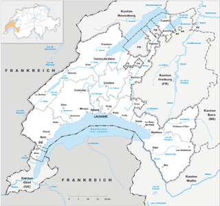
Vaud, more formally the canton of Vaud, is one of the 26 cantons forming the Swiss Confederation. It is composed of ten districts and its capital city is Lausanne. Its flag bears the motto "Liberté et patrie" on a white-green background.

The Alps cover a large area. This article describes the delimitation of the Alps as a whole and of subdivisions of the range, follows the course of the main chain of the Alps and discusses the lakes and glaciers found in the region.

La Dôle is a mountain of the Jura, overlooking Lake Geneva in the westernmost part of the canton of Vaud. Rising to an altitude of 1677 meters, it is the second highest peak in the Swiss portion of the Jura, after Mont Tendre. Administratively, the summit is split between the municipalities of Gingins, Chéserex and La Rippe. The mountain is also close to and easily accessible from Saint-Cergue and the Col de la Givrine to the north, both above 1000 meters and connected to Nyon on Lake Geneva by road and by the Nyon–St-Cergue–Morez Railway. A paved road also climbs to the Chalet de la Dôle below the summit from Gingins.

The Chasseral is a mountain of the Jura Mountains, overlooking Lake Biel in the Swiss canton of Bern. With an elevation of 1,606 metres above sea level, the Chasseral is the highest summit in the canton of Bern outside the Alps. It is also both the northernmost and easternmost mountain reaching over 1,500 metres in the Jura Mountains. West of the summit is located the Chasseral Ouest, where runs the border with the canton of Neuchâtel. The Chasseral Pass is located further on the west.

The Rochers de Naye is a mountain of the Swiss Alps, overlooking Lake Geneva near Montreux and Villeneuve, in the canton of Vaud. They lie on the range separating the basin of Lake Geneva from the valley of the Sarine, on the watershed between the Rhone and the Rhine. The mountain is partially located in the canton of Fribourg, the border between the two cantons culminating on a lower summit named Grande Chaux de Naye.

Lac de Taney is a lake in Valais, Switzerland. Its surface area is 17 ha.

Le Bouveret is a village in the commune of Port-Valais in the Swiss canton of Valais. Situated at the southernmost end of Lake Geneva and close to the French border, Le Bouveret is very much tourism-oriented with several amusement attractions, including the Swiss Vapeur Parc and the water amusement park Aquaparc. Le Bouveret is also the seat of Cesar Ritz Colleges, a Hospitality school.

The Cornettes de Bise is a mountain in the Chablais Alps, overlooking Lake Geneva. At 2,432 metres above sea level, it is the highest summit of the subrange running from Pas de Morgins to Lake Geneva. The mountain is located on the border between France (west) and Switzerland (east).
The Berneuse is a mountain of the western Bernese Alps, above Leysin in the canton of Vaud. It lies on the range east of the Rhone valley, culminating at the Tour d'Aï.

Mont Tendre is a mountain of the Jura, located between the valley of Joux and the basin of Lake Geneva in the canton of Vaud. With an elevation of 1,679 metres above sea level, it is the highest summit of the Swiss portion of the Jura Mountains and, therefore, the highest summit of Switzerland outside the Alps. It is also the most isolated mountain of the canton. It is found in the community of Montricher.

The Dent d'Oche is a mountain in the Haute-Savoie region of France, in the Chablais massif, near the Swiss-French border, that rises to 2,221 m (7,287 ft) in altitude. It towers above Évian, Thonon, and Lake Geneva. It offers a view of the French and Swiss Alps and the Swiss prealps.

The Niremont is a mountain of the Swiss Prealps, in the canton of Fribourg. Due to its rounded shape, it has 2 sub-summits : The Gros Niremont and the Petit Niremont.

Corbetta is a mountain of the Swiss Prealps, in the canton of Fribourg.


