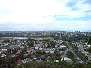
The North Shore is part of the large urban area of Auckland, New Zealand, located to the north of the Waitematā Harbour. To the east, has the Hauraki Gulf, to the west, is West Auckland, to the south, has the Waitematā Harbour and Central Auckland, to the north has the Hibiscus Coast. From 1989 until 2010, North Shore City was an independent city within the Auckland Region, until it was incorporated into the Auckland Council.

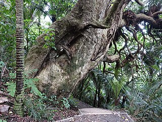
Waipoua Forest is a forest, on the west coast of the Northland Region of New Zealand's North Island. It preserves some of the best examples of kauri forest remaining in New Zealand. It is notable for having two of the largest living kauri trees, Tāne Mahuta and Te Matua Ngahere.
Hakarimata Range is a range of hills on the western edge of Ngāruawāhia township, in the Waikato region of New Zealand, overlooking the confluence of the Waikato and Waipā Rivers. The Hakarimata Range is separated from the Taupiri Range by the Taupiri Gorge, through which the Waikato River flows.
The Waitākere Ranges is a mountain range in New Zealand. Located in West Auckland between metropolitan Auckland and the Tasman Sea, the ranges and its foothills and coasts comprise some 27,720 hectares of public and private land. The area, traditionally known to Māori as Te Wao Nui o Tiriwa, is of local, regional, and national significance. The Waitākere Ranges includes a chain of hills in the Auckland Region, generally running approximately 25 kilometres (16 mi) from north to south, 25 km west of central Auckland. The ranges are part of the Waitākere Ranges Regional Park.

Waitematā Harbour is the main access by sea to Auckland, New Zealand. For this reason it is often referred to as Auckland Harbour, despite the fact that it is one of two harbours adjoining the city. The harbour forms the northern and eastern coasts of the Auckland isthmus and is crossed by the Auckland Harbour Bridge. It is matched on the southern side of the city by the shallower waters of the Manukau Harbour.
Grant Gillon is a former New Zealand politician. He was a member of parliament between 1996 and 2002, representing the Alliance Party, has held a number of seats in local government. He previously served on the Devonport-Takapuna Local Board representing Shore Action.

Northcote is a suburb of Auckland in northern New Zealand. It is situated on the North Shore, on the northern shores of Waitematā Harbour, four km northwest of Auckland CBD. The suburb includes the peninsula of Northcote Point and the northern approaches to the Auckland Harbour Bridge. Northcote Central is to the north of Northcote.

Birkenhead is a suburb of Auckland, in northern New Zealand. It is located on the North Shore of the Waitemata Harbour, four kilometres northwest of the Auckland CBD.

The Hunua Ranges is a mountain range and regional park to the southeast of Auckland city, in the Auckland and Waikato regions of New Zealand's North Island. The ranges cover some 250 square kilometres (97 sq mi) and rise to 688 metres (2255 ft) at Kohukohunui.

Beach Haven is a southwestern suburb of the North Shore, located in Auckland, New Zealand. The area has gentrified rapidly over recent years as young professionals moved into the area.

Huia is a western coastal settlement in West Auckland, New Zealand and forms part of the Waitākere Ranges Regional Park. The majority of houses in Huia are located along Huia Road, which arcs around Huia Bay and heads west towards Little Huia.

Meola Reef, or Te Tokaroa in Māori, is a lava flow forming a reef peninsula across part of Auckland's Waitemata Harbour, New Zealand. The reef extends for over 2 kilometres across the harbour, to within 500 metres of Kauri Point on the northern shore.

Kauri dieback is a forest dieback disease of the native kauri trees of New Zealand that is suspected to be caused by the oomycete Phytophthora agathidicida. Symptoms can include root rot and associated rot in a collar around the base of the tree, bleeding resin, yellowing and chlorosis of the leaves followed by extensive defoliation, and finally, death.

Alice Eaves Scenic Reserve, known colloquially as "Eaves Bush", is a 16ha forest located at the northern end of Orewa, in Auckland, New Zealand. It is named after Alice Caroline Eaves, whose family bequeathed the land to the nation in 1960.

Shore Action is a political ticket which contests the boards and council seats in the North Shore Ward of the Auckland Council. They have a strong focus on retention of local assets and investment in the natural environment, along with a focus on local participation in local body politics.

Kaipātiki is a local government area in New Zealand's Auckland Region, governed by the Kaipātiki Local Board and Auckland Council. It currently aligns with the council's North Shore Ward.

The Te Wai-o-Pareira / Henderson Creek is an estuarine river of the Auckland Region of New Zealand's North Island. It flows north from its sources in the Henderson Valley and Titirangi, before reaching the western Waitematā Harbour.
Little Huia is a western coastal settlement of West Auckland, Auckland, New Zealand and forms part of the Waitākere Ranges Regional Park, bordering the Manukau Harbour. It is located south-west of the settlement of Huia.

The Goldie Bush Scenic Reserve, also known as Goldies Bush and Te Taiapa, is a forested area of West Auckland, New Zealand. Located south-east of Muriwai, the reserve is home to the Mokoroa Falls.
The Okura Bush Scenic Reserve is a protected forested area on the Hibiscus Coast in the Auckland Region, New Zealand. It is the location of the Okura Bush Track.

