Chelsea Sugar Refinery

Last updated

Chelsea Sugar
Chelsea Sugar logo.svg
Chelsea Sugar Refinery.JPG
Chelsea Sugar, as seen from Birkenhead Wharf
Chelsea Sugar Refinery
General information
Coordinates 36°49′16″S174°43′26″E / 36.821°S 174.724°E / -36.821; 174.724
Completed1884;139 years ago (1884)
DesignatedJune 26, 2009;14 years ago (2009-06-26)
Reference no.7792

New Zealand Sugar Company Limited is a long-established business and landmark in Birkenhead, New Zealand, located on the northern shore of Auckland's Waitemata Harbour. The company is also known colloquially as "Chelsea Sugar", taking reference from the company's branded sugar "Chelsea", and the site is also colloquially known as the "Chelsea Sugar Refinery", or "sugar works".

Contents

The refinery was established in 1884, and remains New Zealand's main source of sugar products (for both home use and for the food and beverage industry). This position remained even after New Zealand's deregulation opened the markets in the 1980s to foreign competition, and products are also exported overseas. [1] The refinery also has one of Auckland's deepwater ports, with handysize ships importing raw sugar globally every six weeks. [1]

History

Throughout most of the 19th century, all sugar products in New Zealand had to be imported; wishing to improve New Zealand's self-sufficiency, in 1882 the government offered a bounty to the first company to produce sugar locally. Already interested in business prospects in New Zealand, the Australian Colonial Sugar Refining Company had investigated possible sites in New Zealand and purchased 160 acres (0.65 km2) of farm land in Birkenhead. [2] This was later expanded to 450 acres (1.8 km2). [3]

The site was ideal for a refinery: the Waitemata offered deep water close to shore for a port, and fresh water from Duck Creek, which ran through the estate, and land and timber for building purposes were plentiful. [4] [5]

The name "Chelsea" was bestowed on the site by the refinery's first customs officer, who named it after Chelsea in England, his hometown. [3]

New Zealand Sugar Company established

The "New Zealand Sugar Company" was formed in June 1883 by the Colonial Sugar Refining Company, the Victorian Sugar Company, and a number of prominent Auckland businessmen, including Sir Frederick Whitaker, Allan Kerr Taylor, LD Nathan (of Lion Nathan), and AG Horton and JL Wilson (of Wilson & Horton). However, a collapse in the world sugar market in the 1880s led the New Zealand Sugar Company to be re-amalgamated into its parent company Colonial Sugar in 1888. In 1959, the present New Zealand Sugar Company was formed to allow local autonomy. [2] Wilmar International currently own 75% of the New Zealand Sugar Company, and Mackay Sugar own 25%.

New refinery

The original 1884 building, seen here on the right, is still used today, and forms the basis for the company logo. Chelsea Sugar Refinery3.JPG
The original 1884 building, seen here on the right, is still used today, and forms the basis for the company logo.

Work began on the new refinery in 1883, when 150 workers levelled the ground, reclaimed a natural lagoon, built wharves (by blasting bedrock), and created dams using two-thirds of the 1.5 million bricks which were made on site; the remainder were used in the buildings. By 1884, the refinery was operating, and has not ceased its 24-hour operation since. [5]

Of the 150 workers who built the refinery, 100 remained to work in it once it was complete; most had migrated from Auckland and settled in the area. [6]

Some of the early machinery and equipment was imported from Greenock in Scotland; much of this historic equipment remains on site, providing a rich industrial heritage. [7]

Built in 1909, the row of brick workers' cottages are little changed today. Chelsea brick houses.JPG
Built in 1909, the row of brick workers' cottages are little changed today.

Model village

As work on the refinery began, the managers and company officers were able to adapt the existing farm cottages on the estate for their use, but the majority of workers lived in tents and temporary dwellings near the building site. This shanty town was replaced by Chelsea Village, which consisted of 35 cottages provided by the company within the grounds, some distance from the existing Birkenhead village. Planned to be a model town, it provided gardens, a church, reading room, school, and shop. [6]

However, the village did not remain for many years; the lower houses suffered from dampness and were unoccupied by the early 1890s, and by 1900 it was known as the "barracks" and occupied mainly by single men. In 1905, the village was condemned by the health authorities and the worst of the houses were demolished; the rest were sold and shifted from the site. Some of the relocated cottages can still be seen in the older streets around Birkenhead, and the church, now known as St Peters, was moved to Verrans Corner (a local suburb). [8]

Desiring its core tradesmen to remain on site, in case of emergencies, the company built four semi-detached brick houses in 1909 on the site of the old Chelsea Village. [8] These houses remain in Chelsea's ownership, but are now rented to private individuals. [9] For the remaining workers, the company offered inexpensive housing loans, which financed the building of over a third of Birkenhead's new houses between 1910 and 1926, mainly in the streets surrounding the refinery, including Colonial Road (named after the original sugar company) and Huka Road (after the Maori name for sugar). [8]

Sugar workers

Renowned poet James K Baxter worked at Chelsea as a cleaner in 1969-a job found for him by Hone Tuwhare. [10] Dismissed after three weeks, he wrote the satirical poem "Ballad of the Stonegut Sugar Works" which expressed his unhappiness at the working conditions. [11] Baxter's impression of the factory was not shared by all workers; it was recognised as a place of hard work, but the community spirit was high and the company provided many benefits for workers. The company housing loans and secure employment ensured long service, often complete generations from the same families all working at the refinery. [12]

In the 2000s, about 240 people were occupied at the refinery. [1]

Wider impact

Development of Birkenhead

Before the opening of Auckland's Harbour Bridge in 1959, access to the North Shore from the city was restricted to transport by ferry. While some residents commuted to the city, most of the development of the area was determined by local employment; thus, Chelsea was a leading proponent and determinant in the growth of Birkenhead and provided a focal point for the community. With Chelsea as the major employer, Birkenhead was considered by many to be a 'company town'. [13] In 1900, when the borough's population was 1000, one-third of the men worked at the refinery; local farmers and orchardists relied on casual labour in their off-season. [5]

The bridge opening also meant that Auckland’s North Shore was now a convenient place to live, so Chelsea sold more than 100 hectares of land for subdivision. This is the suburb now known as Chatswood and includes the Chelsea Sugar Refinery.

Before the establishment of the sugar works, the area consisted of farms and orchards, with a small village beside Birkenhead Wharf; within four years of the refinery's opening, Birkenhead had become a borough. [13] The burgeoning town grew up the hill towards Chelsea Village, with a group of shops established at Highbury, between the two original villages. Most of the local shops were supported by business from Chelsea and its workers, and workers became involved in local community affairs, including the offices of mayor and councillor. The shift sirens could be heard throughout Birkenhead and served as a 'clock' for all. [12]

Second port on the Waitemata

The bulk carrier Port Alice docked at Chelsea Wharf for unloading Chelsea Sugar Refinery ship.JPG
The bulk carrier Port Alice docked at Chelsea Wharf for unloading

The site was chosen due to the deepwater access, allowing a port to be built in 1884. Raw sugar came from Fiji, Cuba, Australia, Indonesia, and Peru for refining, and until the building of the Auckland Harbour Bridge, the finished products were shipped out from the wharf. All other commodities, such as coal, food, and mail, were also handled by Chelsea Wharf. [14]

This port continues to accept ships, generally handysize bulk carriers, delivering up to 30,000 tons of raw sugar. [9] It remains private, but arrivals at the port are recorded by the Ports of Auckland [15] and subject to Customs and MAF regulations. [9] As the ships generally exceed 500  gross register tons  (GRT), the ships require pilotage, managed by the Ports of Auckland's Harbour Control. [16]

Some of the land was in the ownership of the Ports of Auckland, and leased to Chelsea. In 1997, approval was granted for Chelsea to purchase the land, a total of nine hectares. [17]

The port is located up-harbour from the Harbour Bridge, thus enforcing a large central span (243.8 m) and height (43.27 m at high tide).

One of the footpaths leading through the grounds Chelsea Refinery footpath.JPG
One of the footpaths leading through the grounds

Architectural and cultural impact

Chelsea is more than a landmark on the coast; it has been central to the development of the local community and remains active in preserving and encouraging interest in the local heritage and local events, sponsoring things as diverse as school trails and the publication of local histories.

As part of the company's interest in preserving its early heritage for later generations, it has entrusted its archives to the Birkenhead Public Library. These Chelsea Archives contain company records, including wage books, legal files, and share registers from throughout its history. [18]

The architectural and social importance of the site is recognised by Heritage New Zealand. The early factory buildings, manager's house, and brick houses have Category II listings, and the site as a whole is recognised for its industrial heritage. As one of the largest complexes in New Zealand, and one of the few refineries in the South Pacific, it helped to established New Zealand as an economic force. [19]

Throughout its history, Chelsea has allowed the public open access to its significant grounds, which comprise wetlands, lakes, open space, and bush. To ensure the parkland -and its access- is maintained, has become a public legacy. [20]

Among the other cultural impacts which the refinery has had on its surrounds is the origin of top local association football team Glenfield Rovers. The club, founded as Chelsea F.C. in 1960, was originally a social club for staff at the refinery. It later became more than just a social side, and has among the strongest teams in the Auckland region since the mid-1990s. The club reached the semifinals of the national Chatham Cup competition in 2008.

In modern times

The current Golden Syrup tin displays an illustration of the 19th-century refinery, a design reflected in the company logo shown on the White Sugar packaging. Chelsea Sugar and Syrup.JPG
The current Golden Syrup tin displays an illustration of the 19th-century refinery, a design reflected in the company logo shown on the White Sugar packaging.

Chelsea operates 24 hours a day, 5 days per week, and remains New Zealand's market leader in sugar products. Chelsea purchases bulk raw sugar globally, which is brought in by ship and processed and packaged at the Refinery. Sales offices and warehouses around the country aid in the distribution of 200,000 tonnes of sugar a year, supplying both retail and manufacturing markets. [21] About 20% of Chelsea's total production is exported, mainly to Australia and the Pacific. [22] New Zealand has a deregulated economy, hence it has no subsidies or import tariffs for sugar, so Chelsea operates entirely within the free market. [21]

Chelsea provide financial support and sponsorship for a variety of organisations and projects within the local community. They also provide funding for the Sugar Research Advisory Service, an independent organisation undertaking and reviewing research into sugar. [23]

Notes

  1. 1 2 3 "Shipload of sugar keeps refinery going at top speed". The New Zealand Herald. 23 December 2009. Retrieved 26 February 2012.
  2. 1 2 Luke, p8
  3. 1 2 Chelsea website: History Archived 7 November 2007 at the Wayback Machine
  4. Luke, p 9
  5. 1 2 3 Howell, p 17
  6. 1 2 Luke, p 5
  7. Howell, p 18
  8. 1 2 3 Luke, p 6
  9. 1 2 3 "Chelsea Website: Estate". Archived from the original on 7 November 2007. Retrieved 7 November 2007.
  10. "NZ Book Council". Archived from the original on 6 June 2014. Retrieved 7 November 2007.
  11. Luke, p 3
  12. 1 2 Luke, p 7
  13. 1 2 Luke, p 4
  14. Howell, p 19
  15. Ports of Auckland shipping schedule Archived 11 October 2007 at the Wayback Machine
  16. "Axis, September 2006, p4" (PDF). Archived from the original (PDF) on 11 April 2008. Retrieved 13 November 2007.
  17. CAFCA notes Sept '97
  18. Shore Libraries Collections: The Chelsea Archive Archived 31 December 2007 at the Wayback Machine
  19. Howell, pp 17–18
  20. "North Shore City Council Press Release 20 December 2005". Archived from the original on 4 March 2016. Retrieved 7 November 2007.
  21. 1 2 Chelsea website: Business Archived 7 November 2007 at the Wayback Machine
  22. Chelsea website: Exports Archived 7 November 2007 at the Wayback Machine
  23. Sugar Research Advisory Service website

Related Research Articles

<span class="mw-page-title-main">Devonport, New Zealand</span> Suburb in Auckland, New Zealand

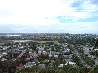
Devonport is a harbourside suburb of Auckland, New Zealand. It is located on the North Shore, at the southern end of the Devonport Peninsula that runs southeast from near Lake Pupuke in Takapuna, forming the northern side of the Waitematā Harbour. East of Devonport lies North Head, the northern promontory guarding the mouth of the harbour.

<span class="mw-page-title-main">Manukau Harbour</span> Harbour in Auckland, New Zealand

The Manukau Harbour is the second largest natural harbour in New Zealand by area. It is located to the southwest of the Auckland isthmus, and opens out into the Tasman Sea.

<span class="mw-page-title-main">North Shore, New Zealand</span> Suburban area in Auckland, North Island, New Zealand

The North Shore is part of the large urban area of Auckland, New Zealand, located to the north of the Waitematā Harbour. To the east, has the Hauraki Gulf, to the west, is West Auckland, to the south, has the Waitematā Harbour and Central Auckland, to the north has the Hibiscus Coast. From 1989 until 2010, North Shore City was an independent city within the Auckland Region, until it was incorporated into the Auckland Council.

<span class="mw-page-title-main">Auckland Harbour Bridge</span> Road bridge in Auckland, New Zealand

The Auckland Harbour Bridge is an eight-lane motorway bridge over the Waitematā Harbour in Auckland, New Zealand. It joins St Marys Bay on the Auckland city side with Northcote on the North Shore side. It is part of State Highway 1 and the Auckland Northern Motorway. The bridge is operated by the NZ Transport Agency (NZTA). It is the second-longest road bridge in New Zealand, and the longest in the North Island.

<span class="mw-page-title-main">Waitematā Harbour</span> Harbour in Auckland, New Zealand

Waitematā Harbour is the main access by sea to Auckland, New Zealand. For this reason it is often referred to as Auckland Harbour, despite the fact that it is one of two harbours adjoining the city. The harbour forms the northern and eastern coasts of the Auckland isthmus and is crossed by the Auckland Harbour Bridge. It is matched on the southern side of the city by the shallower waters of the Manukau Harbour.

CSR Limited is a major Australian industrial company, producing building products and having a 25% share in the Tomago aluminium smelter located near Newcastle, New South Wales. It is publicly traded on the Australian Securities Exchange. In 2021, it had over 3,000 employees and reported an after-tax profit of $146 million. The company has a diversified shareholding with predominantly Australian fund managers and retail owners. The group's corporate headquarters is in North Ryde, Sydney.

<span class="mw-page-title-main">Northcote, Auckland</span> Suburb in Auckland, New Zealand

Northcote is a suburb of Auckland in northern New Zealand. It is situated on the North Shore, on the northern shores of Waitematā Harbour, four km northwest of Auckland CBD. The suburb includes the peninsula of Northcote Point and the northern approaches to the Auckland Harbour Bridge. Northcote Central is to the north of Northcote.

<span class="mw-page-title-main">Birkenhead, New Zealand</span> Suburb in Auckland, New Zealand

Birkenhead is a suburb of Auckland, in northern New Zealand. It is located on the North Shore of the Waitemata Harbour, four kilometres northwest of the Auckland CBD.

<span class="mw-page-title-main">Beach Haven, New Zealand</span> Suburb in Auckland, New Zealand

Beach Haven is a southwestern suburb of the North Shore, located in Auckland, New Zealand. The area has gentrified rapidly over recent years as young professionals moved into the area.

<span class="mw-page-title-main">Chatswood, New Zealand</span> Suburb in Auckland, New Zealand

Chatswood is a suburb in the city of Auckland, New Zealand, in the middle-eastern side of North Shore. It contains a primary school and many parks. To the south of Chatswood is Kendall's Bay, a small bay of the Waitematā Harbour. The suburb is under the governance of Auckland Council. The Royal New Zealand Navy's Kauri Point Armament Depot is located in Chatswood. Chelsea Sugar Refinery is located in Chatswood.

Transport in Auckland, New Zealand's largest city, is defined by factors that include the shape of the Auckland isthmus, the suburban character of much of the urban area, a history of focusing investment on roading projects rather than public transport, and high car-ownership rates.

<span class="mw-page-title-main">Fullers Group</span>

Fullers Group Limited, trading as Fullers360, is a ferry and tourism company in Auckland, New Zealand. It operates in the Hauraki Gulf and Waitematā Harbour. Fullers Group is the latest in a long line of almost continuous harbour and gulf ferry operations based in Auckland since the 1870s.

<span class="mw-page-title-main">Ports of Auckland</span> Company administering Aucklands harbour facilities

Ports of Auckland Limited (POAL), the successor to the Auckland Harbour Board, is the Auckland Council-owned company administering Auckland's commercial freight and cruise ship harbour facilities. As the company operates all of the associated facilities in the Greater Auckland area, this article is about both the current company and the ports of Auckland themselves.

<span class="mw-page-title-main">Wynyard Quarter</span>

The Wynyard Quarter is a reclaimed piece of land on the Waitematā Harbour at the western edge of the Auckland waterfront, New Zealand.

<span class="mw-page-title-main">Marsden Point Oil Refinery</span>

Marsden Point Oil Refinery was a 96,000 BPD refinery located at Marsden Point, Whangarei, Northland, New Zealand. It was the only oil refinery in New Zealand, and is operated by Refining NZ. The point was named after Samuel Marsden. The regional survey map shows it was called Marsden Point in 1907.

<span class="mw-page-title-main">Auckland Ferry Terminal</span> Ferry building

The Auckland Ferry Terminal, also called the Downtown Ferry Terminal, is the hub of the Auckland ferry network, which connects the Auckland CBD with suburbs in North Shore, West Auckland, and South Auckland, and islands in the Hauraki Gulf. The terminal is on the Auckland waterfront, at the north end of Queen Street, across Quay Street from the Britomart Transport Centre, which is the hub for local buses and trains.

Northport is a commercial sea port at Marsden Point, at the entrance to the Whangarei Harbour in Northland, New Zealand, located next to the Marsden Point Oil Refinery. It is a naturally deep-water port, with a maximum depth of 14.5 metres. It is the northernmost multi-purpose port in New Zealand, and the closest port to the majority of New Zealand's international markets. It is about 100 km north of the Auckland Northern Motorway, and around 75 nautical miles north of the Port of Auckland.

<span class="mw-page-title-main">Auckland</span> Metropolitan city in the North Island of New Zealand

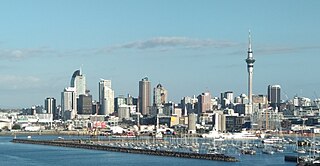
Auckland is a large metropolitan city in the North Island of New Zealand. The most populous urban area in the country and the fifth largest city in Oceania, Auckland has an urban population of about 1,440,300. It is located in the greater Auckland Region—the area governed by Auckland Council—which includes outlying rural areas and the islands of the Hauraki Gulf, and which has a total population of 1,695,200. While Europeans continue to make up the plurality of Auckland's population, the city became multicultural and cosmopolitan in the late-20th century, with Asians accounting for 31% of the city's population in 2018. Auckland is revealed as having the fourth largest foreign-born population in the world, with 39% of its residents born overseas. With its large population of Pasifika New Zealanders, the city is also home to the biggest ethnic Polynesian population in the world. The Māori-language name for Auckland is Tāmaki Makaurau, meaning "Tāmaki desired by many", in reference to the desirability of its natural resources and geography.

Quay Street is the northernmost street in the Auckland CBD, New Zealand. The Auckland Ferry Terminal, which has ferries running to Devonport, Waiheke Island, and other places in Waitematā Harbour; the Hilton Auckland hotel; and Ports of Auckland are on the north side of the street. The Britomart Transport Centre, Queen Elizabeth Square and Grand Mercure Auckland hotel are on the south side.

<span class="mw-page-title-main">Kaipātiki</span> Local board area in Auckland, New Zealand

Kaipātiki is a local government area in New Zealand's Auckland Region, governed by the Kaipātiki Local Board and Auckland Council. It currently aligns with the council's North Shore Ward.

References

Commons-logo.svg Media related to Chelsea Sugar Refinery at Wikimedia Commons