
The Appalachian Mountains, often called the Appalachians, are a system of mountains in eastern to northeastern North America. The Appalachians first formed roughly 480 million years ago during the Ordovician Period. They once reached elevations similar to those of the Alps and the Rocky Mountains before experiencing natural erosion. The Appalachian chain is a barrier to east–west travel, as it forms a series of alternating ridgelines and valleys oriented in opposition to most highways and railroads running east–west.
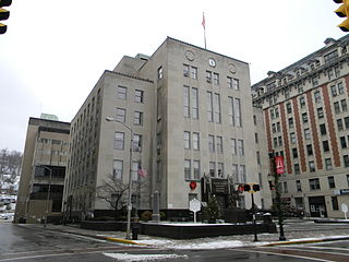
Harrison County is a county in the U.S. state of West Virginia. As of the 2020 census, the population was 65,921. Its county seat is Clarksburg.
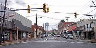
Oak Hill is a city in Fayette County, West Virginia, United States. The population was 8,179 at the 2020 census. It is part of the Beckley metropolitan area.
The Cook Partisan Voting Index, abbreviated Cook PVI, CPVI, or PVI, is a measurement of how strongly a United States congressional district or U.S. state leans toward the Democratic or Republican Party, compared to the nation as a whole, based on how that district or state voted in the previous two presidential elections.

The Cook Political Report with Amy Walter is an American online newsletter that analyzes elections and campaigns for the U.S. Presidency, the United States Senate, the United States House of Representatives, and U.S. governors' offices. Self-described as independent and nonpartisan, it was founded by political analyst Charlie Cook in 1984. Amy Walter is the editor, publisher, and owner.

Pin Oak is an unincorporated community in Hampshire County in the U.S. state of West Virginia. Pin Oak is located along West Virginia Route 29 between Paw Paw and Forks of Cacapon. Pin Oak is roughly centered at the intersection of Pin Oak Road and Cabin Run Road with West Virginia Route 29. The old Pinoak School lies north of this intersection.
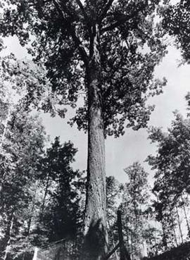
The Mingo Oak was a white oak in the U.S. state of West Virginia. First recognized for its age and size in 1931, the Mingo Oak was the oldest and largest living white oak tree in the world until its death in 1938.

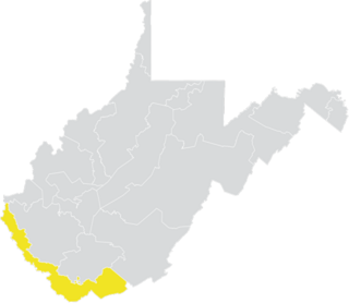
Southern West Virginia is a culturally and geographically distinct region in the U.S. state of West Virginia. Southern West Virginia is known for its coal mining heritage and Southern affinity. The region is also closely identified with Southwestern Virginia and Southeastern Kentucky, with close proximity to Western North Carolina and East Tennessee. Today, Southern West Virginia continues to grapple with poverty and declining population. The region is located in West Virginia's 1st congressional district, which is represented by Carol Miller.

Peters Mountain is a 52-mile (84 km) mountain in the U.S. states of Virginia and West Virginia. It is located on the border between Alleghany County, VA, Monroe County, WV, Giles Co.,VA, and Craig Co.,VA. Its elevation ranges from 4,073 feet (1,241 m) on the mountaintop to a low of 2,300 feet (700 m). It produces some of the water supply for Monroe County.
Michael Angelo Oliverio II is a State Senator for the 13th district and the 2010 Democratic nominee for U.S. Representative for West Virginia's 1st congressional district. He previously served in the West Virginia House of Delegates.
Mossy is an unincorporated community in Fayette County, West Virginia, United States. Mossy is located off exit 60 on the West Virginia Turnpike and is west of Oak Hill. As of 1993, the community had an Exxon gas station, and motel, all owned by Teddy Gray.
White Oak is an unincorporated community in Raleigh County, West Virginia, United States. White Oak is located on West Virginia Route 3, 1.5 miles (2.4 km) southeast of Shady Spring. White Oak has a post office with ZIP code 25989.

The natural environment of Virginia encompasses the physical geography and biology of the U.S. state of Virginia. Virginia has a total area of 42,774.2 square miles (110,784.67 km2), including 3,180.13 square miles (8,236.5 km2) of water, making it the 35th-largest state by area. Forests cover 65% of the state, wetlands and water cover 6% of the land in the state, while 5% of the state is a mixture of commercial, residential, and transitional.

Fair Oaks is a census-designated place in Fairfax County, Virginia, United States. The population as of the 2010 census was 30,223. It encompasses a large area west of the city of Fairfax, centered on Fair Oaks Mall. Suburban neighborhoods and office parks occupy most of Fair Oaks, largely developed since the 1980s.
Oak Ridge is an unincorporated community in Fayette County, West Virginia, United States.

Virginia's 21st Senate district is one of 40 districts in the Senate of Virginia. It has been represented by Democrat John S. Edwards since 1996. Although it voted for Joe Biden, it is currently the most Republican-leaning district to be represented by a Democrat.

The 1932 United States presidential election in West Virginia took place on November 8, 1932, as part of the 1932 United States presidential election. West Virginia voters chose eight representatives, or electors, to the Electoral College, who voted for president and vice president.
West Virginia's 6th Senate district is one of 17 districts in the West Virginia Senate. It is currently represented by Republicans Mark Maynard and Chandler Swope. All districts in the West Virginia Senate elect two members to staggered four-year terms. District 6 is currently the most Republican-leaning district in the Senate.


