Roane County is a county located in the U.S. state of West Virginia. As of the 2010 census, the population was 14,926. Its county seat is Spencer. The county was founded in 1856 and is named for Spencer Roane.

Roane County is a county of the U.S. state of Tennessee. As of the 2010 census, the population was 54,181. Its county seat is Kingston.

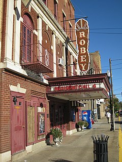
Spencer is a city in and the county seat of Roane County, West Virginia, United States. Originally known as "California," Spencer was chartered in 1858, and named after Spencer Roane (1762–1822), a distinguished jurist from Virginia, who served on the Virginia Supreme Court of Appeals, and for whom Roane County was named. The population was 2,322 at the 2010 census. Spencer is the home of the annual West Virginia Black Walnut Festival. Points of interest include Charles Fork Lake, Chrystal Water and Power Company-Spencer Water and Ice Company, the McIntosh Mansion, and the Robey Theatre.

UTC−05:00 is an identifier for a time offset from UTC of −05:00. In North America, it is observed in the Eastern Time Zone during standard time, and in the Central Time Zone during the other eight months. The western Caribbean uses it year round.

UTC−04:00 is an identifier for a time offset from UTC of −04:00. It is observed in the Eastern Time Zone during the warm months of daylight saving time, as Eastern Daylight Time. The Atlantic Time Zone observes it during standard time . It is observed all year in the Eastern Caribbean and several South American countries.
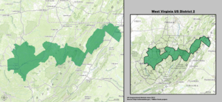
West Virginia's 2nd congressional district currently stretches from the Ohio River border with Ohio to the Potomac River border with Maryland and the border with Virginia. It includes the capital city of Charleston and the rapidly growing residential communities of West Virginia's Eastern Panhandle and Potomac Highlands regions connected by a narrow strip of nearly unpopulated counties. It is 20 miles (32 km) wide and 300 miles (480 km) long.
Stringtown is the name of several places in the U.S. state of West Virginia:
Stringtown can refer to the following:

Stringtown is a small, unincorporated community located along the Stringtown Road near Belington in Barbour County, West Virginia, United States. It traces its route from east to west beginning on West Virginia Route 92, until it intersects with Cross Road, which exits back onto WV 92, then turns south until it intersects with Laurel Mountain Road. On the way, it also intersects with Hunters Fork Road, which travels north and also empties back onto WV 92.
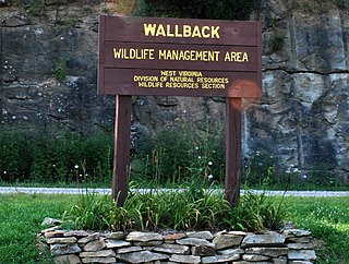
Wallback Wildlife Management Area is located on 11,758 acres (4,758 ha) northwest of Clay in Clay, Kanawha and Roane Counties, West Virginia.

This is a list of the National Register of Historic Places listings in Roane County, West Virginia.
Liverpool is an unincorporated community in Jackson and Roane counties, West Virginia, United States. Liverpool is located along the Right Fork Sandy Creek at the junction of Jackson County Route 13 and Roane County Route 1, 5.7 miles (9.2 km) west of Reedy Liverpool had a post office, which closed on May 30, 1989. The community was named after Liverpool, in England.
Tariff is an unincorporated community in Roane County, West Virginia, United States. Tariff is located along County Route 27 and the Henry Fork, 12 miles (19 km) southeast of Spencer. Tariff had a post office, which opened on February 10, 1890, and closed on October 1, 2005.
Billings is an unincorporated community in Roane County, West Virginia, United States. Billings is located on West Virginia Route 14 and the Left Fork Reedy Creek, 4.5 miles (7.2 km) northwest of Spencer.
Clover is an unincorporated community in Roane County, West Virginia, United States. Clover is located on West Virginia Route 36, 6.5 miles (10.5 km) southeast of Spencer.
Alvy is an unincorporated community in Tyler County, West Virginia, United States. Alvy is located along County Route 13 and Indian Creek, 16 miles (26 km) east-southeast of Middlebourne. Alvy was once Moore, VA changed to Alvy c. 1850 and had a post office, which closed on February 1, 1997; the post office used the name Alvy.

Donna Jean Boley is a Republican member of the West Virginia Senate representing the 3rd district. West Virginia Governor Arch A. Moore, Jr. appointed Boley on May 14, 1985 to fill a seat made vacant by the resignation of Sam White on April 24, 1985. Since her election to White's unexpired term in 1986, Boley has gone on to win re-election nine times. From 1990 to 1996, she was Senate Minority Leader. In 1991 and 1992, Boley was also the only Republican member in the 34-member Senate, making her the minority chairwoman for every single Senate committee.
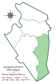
Washington District, formerly Washington Magisterial District, is one of five historic magisterial districts in Jackson County, West Virginia, United States. The district was originally established as one of five civil townships in Jackson County after West Virginia became a state in 1863; in 1872, all of West Virginia's townships were converted into magisterial districts. When Jackson County was redistricted in the 1990s, Washington District was combined with the eastern portion of Ripley District, including the city of Ripley, to form the new Eastern Magisterial District. However, the county's historic magisterial districts continue to exist in the form of tax districts, serving all of their former administrative functions except for the election of county officials.

The Eastern Magisterial District is one of three magisterial districts in Jackson County, West Virginia, United States. It was established during a process of redistricting undertaken in the 1990s. In 2010, 9,882 people lived in the district.

West Virginia's 4th Senate district is one of 17 districts in the West Virginia Senate. It is currently represented by Republicans Eric Tarr and Amy Nichole Grady. All districts in the West Virginia Senate elect two members to staggered four-year terms.


