The Global 200 is the list of ecoregions identified by the World Wide Fund for Nature (WWF), the global conservation organization, as priorities for conservation. According to WWF, an ecoregion is defined as a "relatively large unit of land or water containing a characteristic set of natural communities that share a large majority of their species dynamics, and environmental conditions". For example, based on their levels of endemism, Madagascar gets multiple listings, ancient Lake Baikal gets one, and the North American Great Lakes get none.
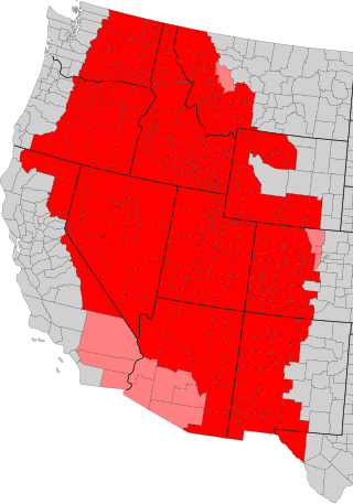
The Intermountain West, or Intermountain Region, is a geographic and geological region of the Western United States. It is located between the Rocky Mountain Front on the east and the Cascade Range and Sierra Nevada on the west.
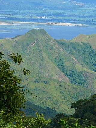
The Cordillera de la Costa montane forests is a montane ecoregion of the tropical and subtropical moist broadleaf forests biome, in the Venezuelan Coastal Range on the Caribbean Sea in northern Venezuela.
The Caribbean bioregion is a biogeographic region that includes the islands of the Caribbean Sea and nearby Atlantic islands, which share a fauna, flora and mycobiota distinct from surrounding bioregions.

The Motagua Valley thornscrub ecoregion is located in the Motagua valley in eastern Guatemala. Surrounded by mountains and receiving relatively little precipitation, the valley is one of the driest in Central America and is characterized by thorn scrub vegetation. It covers an area of 2330 km2 and belongs to the deserts and xeric shrublands biome, as defined by the World Wildlife Fund.

The Belizean pine forests is an ecoregion that represents an example of lowland and premontane pine forests in the Neotropical realm, where the dominant tree species is Caribbean pine. The vegetation here is generally adapted to the xeric, acidic and nutrient-poor conditions along the Belizean near coastal zone of the Caribbean versant.
The Maracaibo dry forests (NT0222) is an ecoregion in Venezuela around Lake Maracaibo. It contains the country's main oil fields. The habitat is criss-crossed by roads and is severely degraded by farming and livestock grazing.

The La Costa xeric shrublands (NT1309) is an ecoregion in Venezuela that stretches along the Caribbean coast. The dry scrub and savanna has been subject to modification since the 16th century by European colonists who replaced it by a patchwork of farm fields and pasturage. Little of the original habitat remains.
The Eastern Java-Bali rain forests ecoregion covers the lowland areas of the eastern half of the island of Java, and the island of Bali, in Indonesia. This ecoregion is distinct from the Eastern Java-Bali montane rain forests, which exists at higher elevations where mountain forest habitat dominates. Very little of the natural lowland rainforest remains in its pre-human settlement state.

The Miskito pine forests ecoregion covers lowland pine forests and savanna along much of the Mosquito Coast in northeastern Nicaragua and southeastern Honduras. Pines are adapted to grow in the poor soil, relative to the surrounding moist forest, and repeated burning have left one species – the Caribbean pine – dominant. Although the ecoregion receives high levels of rain, the hard soils, repeated burning, and exposure to hurricanes have left expanses of 'pine savanna' and seasonal wetlands. The area is thinly settled by humans and there is little crop agriculture.

The Paropamisus xeric woodlands ecoregion covers the portion of northeastern Afghanistan north of the central mountain range and the Hindu Kush Mountains. The name is derived from the Old Persian name for the region, Parupraesanna. While there are low canopy woodlands in the northeast of the ecorgegion, most of the territory is desert or xeric (dry) scrubland.

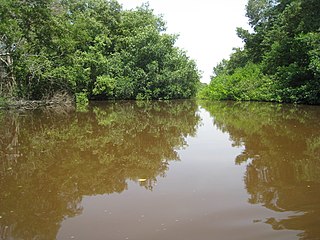
The Coastal Venezuelan mangroves ecoregion covers the salt-water mangrove forests along the Caribbean Sea and Atlantic Ocean coast of Venezuela, from Cocinetas Basin to the edge of the Caño Manamo River and the Orinoco Delta in the east. It is one of the largest mangrove ecoregions in South America, with an area of 5,698 km2, and stretching across over 400 km of Venezuelan coastline.
The Magdalena-Santa Marta mangroves ecoregion covers the mangrove forests along the coast of Colombia on the Caribbean Sea, from Gulf of Urabá in the west at the Colombia-Panama border to the Guajira Peninsula in the east. The region is relatively dry, with low precipitation and high evapotranspiration, so the mangroves depend for water and nutrients on the rivers flowing across the estuarine plain from the Sierra Nevada de Santa Marta mountains to the east. Efforts are currently underway to restore mangroves degraded by development and road building from the 1950s to 1980s.

The Leeward Islands moist forests ecoregion covers the forested areas of the Leeward Islands on the northeastern edge of the Caribbean Sea, stretching from the Virgin Islands in the west to Guadeloupe to the southeast. The forested areas are typically in the core interior of the islands, and at the higher elevations of the volcanic islands. Non-forested lower elevations in the region receive less rainfall and are typically semi-arid. A notable feature of the ecoregion is its position in the main hurricane track. The frequent damage to trees produces in many places an uneven forest canopy, and an opening of the canopy that allows more pre-climax trees to grow.

The Windward Islands xeric scrub ecoregion covers the relatively small areas of the Windward Islands that receive low levels of precipitation. The dry areas of these islands are the low coastal areas that receive less precipitation. Because the dry scrub land is generally flat, near the coast, and not as obviously in need of conservation as the upland forests of the interior, they are more vulnerable to human settlement and development for agriculture.

The Cayman Islands dry forests ecoregion covers about half of the Cayman Islands in the Caribbean Sea. The other half of the low-lying islands are mangroves. The dry forests of Grand Cayman have been heavily cleared or degraded for human development; the less populated islands have more intact wooded habitat.
The Cayman Islands xeric scrub ecoregion covers a portion of the Cayman Islands in the Caribbean Sea. The dry ('xeric') parts of the island are surrounded by mangroves, dry forest, or developed areas. Grand Cayman Island has been heavily cleared or degraded for human development; while the less populated islands have more intact shrub and wooded habitat.
The Lesser Antillean dry forests ecoregion covers the dry forests of the coastal lowlands of the Lesser Antilles, where the eastern Caribbean Sea meets the Atlantic Ocean. These forests generally form a band around the interior wet forests of higher elevations, and because they are often flat, they are under the most pressure for human settlement and agriculture.

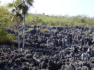
The Aruba-Curaçao-Bonaire cactus scrub ecoregion covers the dry land on the semi-arid islands of Aruba, Curaçao, and Bonaire in the southern Caribbean Sea, about 80 km from the mainland of Venezuela. In low-lying coastal areas the islands also support mangrove wetlands. The landscape features a range of cactus species and acacia trees.

