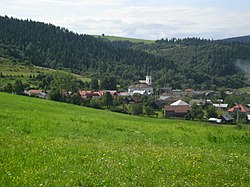
Andrejová is a village and municipality in Bardejov District in the Prešov Region of Slovakia. The predominant religion is the Greek Catholic Church with 4.9% Eastern Orthodox. The Catholic Church of Virgin Mary the Protectrice of 1893 can be found in the village. The village lies at an altitude of 325 metres and covers an area of 11.679 km2. It has a population of about 362 inhabitants. The village is about 51% Slovak, 20% Rusyn, 16% Romany and 11% Ukrainian with minorities. The village used to have public library. There is a football pitch and volleyball playground.

Zboj is a village and municipality in Snina District in the Prešov Region of north-eastern Slovakia.
Pichne is a village and municipality in Snina District in the Prešov Region of north-eastern Slovakia.

Runina is a village and municipality in Snina District in the Prešov Region of north-eastern Slovakia. The first written reference of the village dates back to 1569. The municipality lies at an altitude of 550 metres and covers an area of 22.198 km2. According to the 2013 census it had a population of 75 inhabitants.

Ubľa is a border village and municipality in Snina District in the Prešov Region of north-eastern Slovakia on the border with Ukraine.
Stráne pod Tatrami is a village and municipality in Kežmarok District in the Prešov Region of north Slovakia.

Veľká Franková is a village and municipality in Kežmarok District in the Prešov Region of north Slovakia. The village is traditionally inhabited by Rusyns, as one of their westernmost settlements.

Osturňa is a village and municipality in Kežmarok District in the Prešov Region of north Slovakia. The village was traditionally inhabited by Greek Catholic Rusyns and Gorals, as one of their westernmost settlements.

Stakčínska Roztoka is a village and municipality in Snina District in the Prešov Region of north-eastern Slovakia.

Uličské Krivé is a village and municipality in Snina District in the Prešov Region of north-eastern Slovakia. In historical records the village was first mentioned in 1478. The municipality lies at an altitude of 285 metres and covers an area of 19.132 km2. According to the 2013 census it had a population of 255 inhabitants.
Strihovce is a village and municipality in Snina District in the Prešov Region of north-eastern Slovakia.

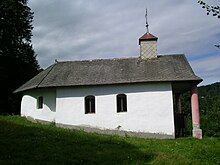
Ruský Potok is a village and municipality in Snina District in the Prešov Region of north-eastern Slovakia. In historical records the village was first mentioned in 1635. A Rusyn wooden Orthodox church dedicated to the Archangel Michael is located in the village, it was built in 1740.

Stakčín is a larger village and a municipality in Snina District in the Prešov Region of north-eastern Slovakia.

Osadné is a village and municipality in Snina District in the Prešov Region of north-eastern Slovakia.
Pčoliné is a village and municipality in Snina District in the Prešov Region of north-eastern Slovakia.
Príslop is a village and municipality in Snina District in the Prešov Region of north-eastern Slovakia.
Ulič is a village and municipality in Snina District in the Prešov Region of north-eastern Slovakia.

Šmigovec is a village and municipality in Snina District in the Prešov Region of north-eastern Slovakia.

Veľký Lipník is a former Lemko village and municipality in Stará Ľubovňa District in the Prešov Region of northern Slovakia. The village is traditionally inhabited by Rusyny/Ruthenians, as one of their westernmost settlements. There is Greek Catholic church built in 1794.

Stráňany is a village and municipality in Stará Ľubovňa District in the Prešov Region of northern Slovakia. The village is traditionally inhabited by Rusyns, as one of their westernmost settlements. There is Greek Catholic church built in 1857.