Prešov Region

Last updated • 2 min readFrom Wikipedia, The Free Encyclopedia
Prešov Region
Prešovský Kraj
High Tatras from Matejovce.jpg
Levoca (2).jpg
Stara Lubovna Hrad-03.JPG
Prvy maj, Presov 21 Slovakia 12.jpg
Spisska Kapitula 0100695.jpg
Narodna prirodna rezervacia Stuzica, Narodny park Poloniny (02).jpg
Bodruzal (11).jpg
Panorama Lodowa Przelecz a1.JPG
From the top to bottom-left; High Tatras, Levoča, Stará Ľubovňa, Co-Cathedral of Saint Nicholas in Prešov, Spišská Kapitula, Stužica primeval forest, Bodružal, Sedielko mountain pass in High Tatras
Presovsky vlajka.svg
Coat of Arms of Presov Region.svg
Presovsky kraj in Slovakia.svg
Prešov Region
CountryFlag of Slovakia.svg  Slovakia
Capital Prešov
Government
  Governor Milan Majerský (KDH)
Area
  Total
8,973.69 km2 (3,464.76 sq mi)
Highest elevation
2,654 m (8,707 ft)
Lowest elevation
105 m (344 ft)
Population
 (2021 census)
  Total
808,931
  Density90/km2 (230/sq mi)
GDP
[1]
  Total€7.451 billion (2016)
  Per capita€9,070 (2016)
Time zone UTC+1 (CET)
  Summer (DST) UTC+2 (CEST)
ISO 3166 code SK-PV
Website www.po-kraj.sk/sk/

The Prešov Region (Slovak : Prešovský kraj , pronounced [ˈpreʂɔwskiːˈkraj] ; Hungarian : Eperjesi kerület), also Priashiv Region [2] (Ukrainian : Пряшівський край, romanized: Priashivskyi krai, pronounced [prʲaʃivsʲkɪjkraj] ), is one of the eight Slovak administrative regions and consists of 13 districts (okresy) and 666 municipalities, 23 of which have town status. The region was established in 1996 and is the most populous of all the regions in Slovakia. [3] Its administrative center is the city of Prešov.

Contents

Geography

It is located in the north-eastern Slovakia and has an area of 8,975 km2. The region has a predominantly mountainous landscape. The subdivisions of TatrasHigh Tatras and Belianske Tatras lie almost entirely in the region and include the highest point of Slovakia – Gerlachovský štít (2,654 ASL). Other mountain ranges and highlands in the region are Šarišská vrchovina, Čergov, Ondavská vrchovina, Slanské vrchy, Pieniny, Levoča Hills, Laborecká vrchovina, Bukovské vrchy, Vihorlat Mountains and Eastern Slovak Lowland. The basins in Prešov Region are Podtatranská kotlina, Hornádska kotlina and Košice Basin.

Major rivers in the region include the Poprad in the west, which is the only major Slovak river in the Baltic Sea watershed, a small part of Hornád in the south-west, a small part of Dunajec in the north, the Torysa in the centre and the Ondava and Laborec in the east. As for administrative divisions, the region borders on the Lesser Poland and Subcarpathian voivodeships in Poland in the north, Zakarpattia Oblast of Ukraine in the east, Košice Region in the south, Banská Bystrica Region in the south-west and Žilina Region in the west.

Demographics

Historical population
YearPop.±%
1970605,772    
1980678,386+12.0%
1991739,264+9.0%
2001789,968+6.9%
2011814,527+3.1%
2021808,931−0.7%
Source: Censuses [4] [5]

The population density in the region is 92.13/km2 (238.6/sq mi) (2020-06-30/-07-01), [6] which is below the country's average (110 per km2). The largest towns are Prešov, Poprad, Humenné, Bardejov and Snina. According to the 2011 census, there were 814,527 inhabitants in the region, with a majority of Slovaks (90.7%), with minorities of Roma (4.0%), Rusyns (2.7%) and there are small minorities of Ukrainians (<1%) and Czechs (<0.5%). [7]

Politics

The current governor of Prešov region is Milan Majerský (KDH). He won with 42% of the vote. In the 2017 election a regional parliament was also elected.

County Council of Prešov region
Coat of Arms of Presov Region.svg
Type
Type
HousesCounty Council
Leadership
Governor
Structure
Seats65
Presovparliament.svg
Political groups
  Centre-right group [8] (20)
  Voice (20)
  Independent group (9) [9]
  Together for Region (8) [10]
  Non-affiliated (8) [11]
Elections
Last election
29 October 2022
Meeting place
Prešov
Website
County Council of Prešov region

Administrative division

The Prešov Region consists of 13 districts. There are 666 municipalities, of which 23 are towns, where about half of the region's population live.

Districts:

See also

Related Research Articles

<span class="mw-page-title-main">Poprad</span> City in Slovakia

Poprad is a city in northern Slovakia at the foot of the High Tatra Mountains, famous for its picturesque historic centre and as a holiday resort. The largest town of the Spiš region and the largest of all towns in the vicinity of the High Tatra Mountains in both Slovakia and Poland, Poprad is the tenth largest city in Slovakia, with a population of approximately 50,000.

<span class="mw-page-title-main">Spiš</span> Historical region in Slovakia and Poland

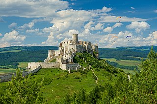
Spiš is a region in north-eastern Slovakia, with a very small area in south-eastern Poland. Spiš is an informal designation of the territory, but it is also the name of one of the 21 official tourism regions of Slovakia. The region is not an administrative division in its own right, but between the late 11th century and 1920 it was an administrative county of the Kingdom of Hungary.

<span class="mw-page-title-main">Places inhabited by Rusyns</span>

The contemporary administrative entities roughly corresponding the traditional territory of settlement of the Rusyns. Following areas have been included which still are or up to the World War II were inhabited by each of the Rusyn sub-ethnicities mentioned below:

<span class="mw-page-title-main">Prešov</span> City in Slovakia

Prešov is a city in Eastern Slovakia. It is the seat of administrative Prešov Region and Šariš. With a population of approximately 85,000 for the city, and in total about 100,000 with the metropolitan area, it is the third-largest city in Slovakia. It belongs to the Košice-Prešov agglomeration and is the natural cultural, economic, transport and administrative center of the Šariš region. It lends its name to the Eperjes-Tokaj Hill-Chain which was considered as the geographic entity on the first map of Hungary from 1528. There are many tourist attractions in Prešov such as castles, pools and the old town.

<span class="mw-page-title-main">Nitra Region</span> Region of Slovakia

The Nitra Region is one of the administrative regions of Slovakia. It was first established in 1923 and from 1996 exists in its present borders. It consists of seven districts and 354 municipalities, from which 16 have a town status. The economy of the region focuses more on agriculture, than in other Slovak regions. Nitra is its seat, largest city, and cultural and economic center.

<span class="mw-page-title-main">Zemplín (region)</span>

Zemplín is the name of an informal traditional region located in eastern Slovakia. It includes the Slovak part of the former Zemplén county, often including the Slovak part of the Ung county.

<span class="mw-page-title-main">Divisions of the Carpathians</span> Categorization of the Carpathian mountains system

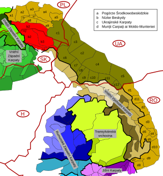
Divisions of the Carpathians are a categorization of the Carpathian mountains system.

<span class="mw-page-title-main">Žilina Region</span> Region of Slovakia

The Žilina Region is one of the eight Slovak administrative regions and consists of 11 districts (okresy) and 315 municipalities, from which 18 have a town status. The region was established in 1923, however, in its present borders exists from 1996. It is a more industrial region with several large towns. Žilina is the region administrative center and there is a strong cultural environment in Martin.

<span class="mw-page-title-main">Banská Bystrica Region</span> Region of Slovakia

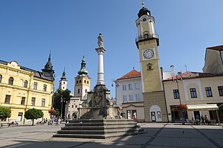
The Banská Bystrica Region is one of the eight regions of Slovakia. It is the largest of the eight regions by area, and has a lower population density than any other region. The Banská Bystrica Region was established in 1923; its borders were last adjusted in 1996. Banská Bystrica consists of 514 municipalities, 24 of which have town status. Its administrative center is the eponymous town of Banská Bystrica, which is also the region's largest town. Other important towns are Zvolen and Lučenec.

<span class="mw-page-title-main">Košice Region</span> Region of Slovakia

The Košice Region is one of the eight Slovak administrative regions. The region was first established in 1923 and its present borders were established in 1996. It consists of 11 districts (okresy) and 440 municipalities, 17 of which have a town status. About one third of the region's population lives in the agglomeration of Košice, which is its main economic and cultural centre.

<span class="mw-page-title-main">Stará Ľubovňa</span> City in Slovakia

Stará Ľubovňa is a town with approximately 16,000 inhabitants in northeastern Slovakia. The town consists of the districts Podsadek and Stará Ľubovňa.

Abrahámovce is a village and municipality in Bardejov District in the Prešov Region of north-east Slovakia. The municipality lies at an altitude of 265 metres and covers an area of 5.899 km2. It has a population of about 342 people. The village is about 99% Slovak. The village has a public library and a football pitch.

<span class="mw-page-title-main">Stará Lesná</span> Village in Slovakia

Stará Lesná or "Old Forest" is a village and municipality in Kežmarok District in the Prešov Region in north-central Slovakia. Stará Lesná is located in an area traditionally known as Spiš and it is situated within the Slovak Tourism Region of the Tatras.

<span class="mw-page-title-main">Cirocha</span> River in Slovakia

Cirocha is a right tributary of the river Laborec in the Prešov Region of eastern Slovakia. It is 50.1 km (31.1 mi) long and its drainage basin size is 499.8 km2 (193.0 sq mi). Its average flow is 2.85 m³/s in Snina.

<span class="mw-page-title-main">Low Beskids</span> Mountain range in Poland and Slovakia

The Low Beskids or Central Beskids are a mountain range in southeastern Poland and northeastern Slovakia. They constitute a middle (central) section of the Beskids, within the Outer Eastern Carpathians.

<span class="mw-page-title-main">Podhale-Magura Area</span> Mountain range in Eastern Europe

The Podhale-Magura Area — is a geomorphologic region of mountain ranges in northern Slovakia and southern Poland, belonging to the Outer Western Carpathians within the Carpathian Mountains system.

<span class="mw-page-title-main">Levoča Mountains</span>

The Levoča Mountains is a mountain range in the Prešov Region of northern Slovakia. Geologically the range stands within the Podhale-Magura Area of the Outer Western Carpathians.

<span class="mw-page-title-main">Vladimír Ledecký</span> Slovak politician

Vladimír Ledecký is a Slovak politician who was a member of the National Council of Slovakia and former state secretary at the Ministry of Investments, Regional Development and Informatization of Slovakia. He was a member of the presidency of For the People, where he acted as a guarantor for regional development. Ledecký served as mayor of Spišský Hrhov from 1998 until 2020 as well as deputy of the Prešov self-governing region from 2005 until 2022. Ledecký has been the SaS parliamentary club since 2023.

References

  1. Regions and Cities > Regional Statistics > Regional Economy > Regional GDP per Capita, OECD.Stats. Accessed on 16 November 2018.
    • Magocsi, Paul R. (1999). Of the Making of Nationalities There is No End: Speeches, debates, bibliographic works. East European Monographs. p. 130. ISBN   9780880334389.
    • Horbal, Bogdan; Krafcik, Patricia Ann; Rusinko, Elaine (2006). Carpatho-Rusyns and Their Neighbors: Essays in Honor of Paul Robert Magocsi. Eastern Christian Publications. p. 82. ISBN   9781892278630.
    • Liber, George O. (2016). Total Wars and the Making of Modern Ukraine, 1914-1954. University of Toronto Press. p. 269. ISBN   9781442627086.
  2. "Demografia Prešovského samosprávneho kraja - VÚC Prešov" (in Slovak). Po-kraj.sk. Archived from the original on 2013-09-25. Retrieved 2013-08-19.
  3. "Statistical lexikon of municipalities 1970-2011" (PDF) (in Slovak).
  4. "Census 2021 - Population - Basic results". Statistical Office of the Slovak Republic. 2021-01-01.
  5. "Statistic of Slovak places by Dušan Kreheľ – Export" . Retrieved 2021-07-05.
  6. "POPULATION AND HOUSING CENSUS 2001 - Tab. 3a". 2006-11-29. Archived from the original on November 29, 2006. Retrieved 2013-08-19.{{cite web}}: CS1 maint: unfit URL (link)
  7. SaS, KDH,

  8.   Independent (8)
      STANK (1)

  9.   Independent (8)

  10.   Independent (4)
      Chance, PS, DS, ODS, Together (1)
      Direction (1)
      Republic (1)
      Dawn (1)

Further reading