
Old Pasadena, often referred to as Old Town Pasadena or simply Old Town, is the original commercial center of Pasadena, a city in California, United States, and had a latter-day revitalization after a period of decay.

Downtown New Haven is the neighborhood located in the heart of the city of New Haven, Connecticut. It is made up of the original nine squares laid out in 1638 to form New Haven, including the New Haven Green, and the immediate surrounding central business district, as well as a significant portion of the Yale University campus. The area includes many restaurants, cafes, theaters and stores. Downtown is bordered by Wooster Square to the east, Long Wharf to the southeast, the Hill neighborhood to the south, the Dwight neighborhood to the west, the Dixwell neighborhood to the northwest, the Prospect Hill area to the north, and East Rock to the northeast.

Brindleyplace is a large mixed-use canalside development, in the Westside district of Birmingham, England. It was named after Brindley Place, the name of the street around which it is built. It was developed by the Argent Group from 1993 onwards.

Cardiff city centre is the city centre and central business district of Cardiff, Wales. The area is tightly bound by the River Taff to the west, the Civic Centre to the north and railway lines and two railway stations – Central and Queen Street – to the south and east respectively. Cardiff became a city in 1905.

Civic is the city centre or central business district of Canberra. "Civic" is a common name for the district, but it is also called Civic Centre, City Centre, Canberra City and Canberra, and its official division name is City.
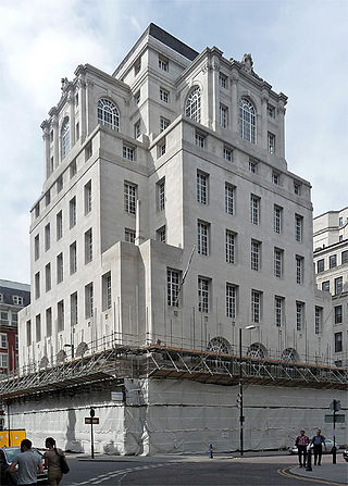
100 King Street, formerly the Midland Bank, is a former bank premises on King Street in Manchester, England. It was designed by Sir Edwin Lutyens in 1928 and constructed in 1933–35. It is Lutyens' major work in Manchester and was designated a Grade II* listed building in 1974.

The Big City Plan is a major development plan for the city centre of Birmingham, England.

The Headrow is an avenue in Leeds city centre, West Yorkshire, England.
The City of Oklahoma City uses Special Zoning Districts as a tool to maintain the character of many neighborhood communities.
Formal education in Sheffield, England, takes place at the city's two universities, 141 primary schools and 28 secondary schools.

The former Sheffield Central Technical School (CTS) was housed in the collection of buildings now called Leopold Square in the city centre of Sheffield, South Yorkshire, England. The complex of buildings home to the school is bounded by Leopold Street, West Street, Orchard Lane, and Holly Street.

West One is a mixed-use development at the centre of the Devonshire Quarter in the city centre of Sheffield, South Yorkshire, England. It comprises bars, restaurants and shops at ground-level and apartments housing over 1,000 people above, including a penthouse. It faces onto Devonshire Green, and provides easy access to the Moor and Division Street.
Market Square Park is a public park in Downtown Houston, Texas, United States. Originally set aside by the Houston Town Company as "Congress Square," the public square was used as a marketplace and city hall, which assumed the name, "Market Square." The City of Houston constructed four different market house/city halls, the first of which opened in 1840. The fourth was constructed in 1904. Market Square is a central feature of the Main Street/Market Square Historic District, a historic district listed on the National Register of Historic Places. The square is surrounded by a combination of nineteenth-century architecture and modern residential towers, with ground leases housing a variety of restaurants and bars.

Downtown Oklahoma City is located at the geographic center of the Oklahoma City metropolitan area and contains the principal, central business district of the region. Downtown has over 80,000 workers and over 13,310,000 sq ft (1,237,000 m2) of leasable office space to-date. Downtown Oklahoma City is the legal, financial, economic, nightlife, and entertainment center of the region.
Oakland's Civic Center neighborhood is a residential and public building district on the east side of Oakland's Central Business District. Its borders are roughly Downtown and Harrison Street to the west, the East Lake Neighborhood and Lakeshore Avenue to the east, the Lakeside Apartments District and 14th Street to the North, and Chinatown and 11th Street to the South.

Hallam Towers is a fifteen-storey, 48 metres (157 ft) apartment building completed in 2022 in the Broomhill area of Sheffield, South Yorkshire, England. It was constructed on the site of an externally similar thirteen-storey former hotel of the same name, which existed on the site between 1963 and 2017.
192 Shoreham Street in Sheffield, England, is a building with striking architectural design. It has been identified by The Atlantic as one of 2012's most interesting buildings and received an RIBA award in 2013. The £1 million renovation designed by Project Orange features an angular postmodern addition on top of a brick warehouse on the lower floor. The original part of the building was converted to be used as a bar/restaurant and had a steel structure added to support the weight of the rooftop offices.

Paradise, formerly named Paradise Circus, is the name given to an area of approximately 7 hectares in Birmingham city centre between Chamberlain and Centenary Squares. The area has been part of the civic centre of Birmingham, England since the 19th century when it contained buildings such as the Town Hall, Mason Science College, Birmingham and Midland Institute buildings and Central Library. The site was redeveloped from 1960 to 1975 into the present Paradise Circus based within a roundabout on the Inner Ring Road system containing a new Central Library and School of Music. From 2015, Argent Group will redevelop the area into new mixed use buildings and public squares.
Ellicott Development Co. is an American property management, leasing and development real estate firm based in Buffalo, New York and led by CEO William Paladino. The company's asset base includes residential, commercial, hotels, parking garages, and convenience stores. Ellicott Development Co.’s services include legal, administrative, financial, management, accounting, development, site selection, site assemblage, architectural design and drafting services, construction, leasing, maintenance, janitorial and security services.
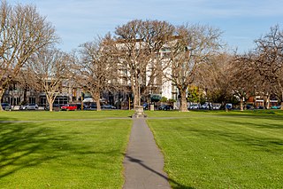
Latimer Square is an urban park in central Christchurch, New Zealand. It is located 400 metres (440 yd) east of the city's centre, Cathedral Square. Many commemorative events take place in Latimer Square. The square lies between the major urban thoroughfares of Gloucester Street and Worcester Street. Madras Street runs north and south to Latimer Square. The square is grassed and crossed by concrete paths and edged by mature trees. It covers an area of a little over 1.8 hectares.


