
The South Yorkshire Supertram, sometimes referred to as the Sheffield Supertram, is a tram and tram-train network covering Sheffield and Rotherham in South Yorkshire, England. The network is owned and operated by the South Yorkshire Mayoral Combined Authority (SYMCA).

Sheffield station is a combined railway station and tram stop in Sheffield, England; it is the busiest station in South Yorkshire, and the third busiest in Yorkshire & the Humber. Adjacent is the Sheffield Supertram stop.

Flinders Street is a street in Melbourne, Victoria, Australia. Running roughly parallel to the Yarra River, Flinders Street forms the southern edge of the Hoddle Grid. It is exactly 1 mi (1.6 km) in length and one and a half chains in width.

Meadowhall Interchange is a transport interchange located in north-east Sheffield, consisting of a combined heavy rail station, tram stop and bus and coach station. The second-busiest heavy rail station in the city in terms of passenger numbers, Meadowhall Interchange provides connections between National Rail services, the Sheffield Supertram light rail network, intercity coach services and the city bus network.

Gleadless Valley ward—which includes the districts of Gleadless Valley, Heeley, Lowfield, and Meersbrook—is one of the 28 electoral wards in City of Sheffield, England. It is located in the southern part of the city and covers an area of 4.5 km2. The population of this ward in 2011 was 21,089 people in 9,516 households. It is one of the five wards that form the Sheffield Heeley parliamentary constituency in the House of Commons. Gleadless Valley actually describes the valley that separates Hemsworth from Herdings, and is a broad area that covers several housing estates: Hemsworth, Herdings and Rollestone. Gleadless Valley is bordered by Gleadless and Norton.
This timeline of Sheffield history summarises key events in the history of Sheffield, a city in England. The origins of the city can be traced back to the founding of a settlement in a clearing beside the River Sheaf in the second half of the 1st millennium AD. The area had seen human occupation since at least the last ice age, but significant growth in the settlements that are now incorporated into the city did not occur until the Industrial Revolution.

Transport in Sheffield, England is developed around the city's unusual topography and medieval street plan. Once an isolated town, the transport infrastructure changed dramatically in the 19th and 20th centuries. The city now has road and rail links with the rest of the country, and road, bus and trams for local transport.

Castle Market was an indoor market in Sheffield city centre, England. The building lay in the north-east of the present city centre, by the River Don, and was built on top of the remains of Sheffield Castle, which could still be seen via guided tours. The market closed in 2013 when the Moor Market opened on The Moor, further south in Sheffield city centre, and demolition began in 2015.

Sheffield Interchange is the main bus station in central Sheffield, South Yorkshire, England. The facility is served by buses operating across the Sheffield region, as well as National Express coaches that connect Sheffield with destinations across the United Kingdom.

South Yorkshire Passenger Transport Executive (SYPTE) was the passenger transport executive for South Yorkshire. It was responsible for implementing policies set by the South Yorkshire Passenger Transport Authority (SYPTA) and for operation of the Authority's bus fleet from its formation in 1974 until its dissolution in 2023, when its assets and duties were transferred to the South Yorkshire Mayoral Combined Authority.

Fitzalan Square is a municipal square situated in the city centre of Sheffield in South Yorkshire, England. The present day square is one of the busiest areas of the city centre, with traffic and pedestrians continually moving through the area. It has a Sheffield Supertram stop and a taxi rank.

Sheffield Tramway was an extensive tramway network serving the English city of Sheffield and its suburbs.

Hillsborough Park is a large parkland area in Hillsborough, Sheffield, South Yorkshire, England. It is situated three miles north-west of the city centre. It is owned by Sheffield City Council and is one of the 13 designated "City Parks".

Sheffield City Centre is a district of the City of Sheffield and is covered partly by the City ward of the City of Sheffield. It includes the area that is within a radius of roughly 0.75 miles (1.2 km) of Sheffield Cathedral and is encircled by the Inner Ring Road, a circular route started in the late 1960s and completed in 2007. As well as the cathedral, buildings in the city centre include the Grade I listed Town Hall, the City Hall and the Winter Gardens. Several areas of the city centre have been designated as quarters. It is home to the city's major business, transport, leisure and cultural attractions.
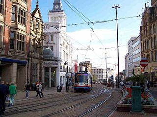
High Street is one of the main thoroughfares and shopping areas in the city centre of Sheffield in South Yorkshire, England, located at the approximate grid reference of SK356874. High Street starts at the Commercial Street, Fitzalan Square and Haymarket junction and runs for approximately 400 metres west to conclude near the Sheffield Cathedral where it forms a Y-junction with Fargate and Church Street. High Street has the traditional wide variety of shops, financial institutions and eating places which are associated with any British town centre.

The recorded history of Wetherby, a market town in the City of Leeds metropolitan borough, West Yorkshire, England, began in the 12th and 13th centuries, when the Knights Templar and later the Knights Hospitallers were granted land and properties in Yorkshire. The preceptory founded in 1217 was at Ribston Park. In 1240, the Knights Templar were granted by the Royal Charter of Henry III the right to hold a market in Wetherby. The charter stated the market should be held on Thursdays, and an annual fair was permitted lasting three days over the day of St James the Apostle.
Walkley is a suburb of Sheffield, England, west of Burngreave, south of Hillsborough and north-east of Crookes.
Arundel Gate is one of the main thoroughfares in Sheffield, England. It is located in the Heart of the City area of Sheffield City Centre. Arundel Gate also features a fifteen-stand bus station, including a ticket office building, completed in 2005.
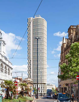
Kings Tower is an approved skyscraper that will be located on Castle Square at the junction of High Street and Angel Street in Sheffield, South Yorkshire. With a planned height of 120 m (390 ft) once completed, Kings Tower will overtake Code Sheffield, and St Pauls Tower as the tallest building in Sheffield and in Yorkshire. Plans for the tower were submitted by architects Hodder + Partners in September 2020, calling initially for a 39-storey tower. Planning permission was granted in December 2020, and construction is planned to complete in 2023. Amended plans were submitted in late 2022, adding a 40th floor to the project.
Public transport in South Yorkshire, England mainly consists of three modes: bus, tram and train. Passengers can switch between these modes of transport at various interchanges operated by the South Yorkshire Combined Mayoral Authority.


