
Glossop is a market town in the borough of High Peak, Derbyshire, England, 15 miles (24 km) east of Manchester, 24 miles (39 km) north-west of Sheffield and 32 miles (51 km) north of Matlock. Near Derbyshire's borders with Cheshire, Greater Manchester, South Yorkshire and West Yorkshire, between 150 and 300 metres above sea level, it is bounded by the Peak District National Park to the south, east and north. In 2021, it had a population of 33,340.

City ward — which includes the districts of Highfield, Kelham Island and the city centre — is one of the 28 electoral wards in City of Sheffield, England. It covers the central area of the city. The ward was created following the 2015 local government boundary review out of part of the old Central ward, which, with a population of 36,412, was the largest ward in the UK. City is one of the wards that make up the Sheffield Central constituency.

Mosborough is an electoral ward of the City of Sheffield, England, in the eastern part of the city, on the border with North East Derbyshire District. The population in 2011 was 17,097. It is one of the wards that make up the Sheffield South East constituency.

The Riverside Quarter, or Riverside Exchange is one of Sheffield's 11 designated City Centre Quarters. Its borders are West Bar, Coulston Street, Bridge Street, Castlegate, Exchange Place and the Parkway to its south, the Wicker Viaduct, Johnson Street, Spitalfields and Nursery Street to the North, and Corporation Street to the west. It is named after the Whitbread Exchange Brewery, which was formerly located on the site of the current developments, and incorporates the Victoria Quays.

Castle Market was an indoor market in Sheffield city centre, England. The building lay in the north-east of the present city centre, by the River Don, and was built on top of the remains of Sheffield Castle, which could still be seen via guided tours. The market closed in 2013 when the Moor Market opened on The Moor, further south in Sheffield city centre, and demolition began in 2015.

Sheffield City Centre is a district of the City of Sheffield and is covered partly by the City ward of the City of Sheffield. It includes the area that is within a radius of roughly 0.75 miles (1.2 km) of Sheffield Cathedral and is encircled by the Inner Ring Road, a circular route started in the late 1960s and completed in 2007. As well as the cathedral, buildings in the city centre include the Grade I listed Town Hall, the City Hall and the Winter Gardens. Several areas of the city centre have been designated as quarters. It is home to the city's major business, transport, leisure and cultural attractions.
Heart of the City II is a mixed-use development under construction in Sheffield city centre, England between the Devonshire Quarter and The Moor Gateway. The project was previously given the marketing name Sevenstone, prior to Hammerson, the developer, being dropped from the project in December 2013 with Sheffield City Council seeking new developers.
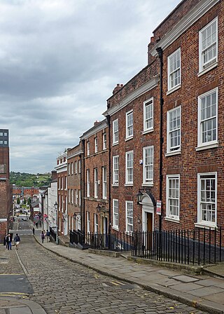
The West End is a loosely defined area of Sheffield, consisting of part of the City Centre, in addition to some of the western suburbs. The term has been in use for at least 150 years.
The Cathedral Quarter is one of Sheffield's eleven designated quarters, located around and named after the Cathedral. It is bound by Tenter Street to the Northwest, West Bar to the North, Snig Hill to the North east, Angel Street to the East, High Street and Church Street to the south and Townhead Street around its western corner.

The Castlegate Quarter is one of the eleven quarters of Sheffield city centre. It is named after Castlegate, the quarter's main thoroughfare. The boundaries of the Castlegate Quarter are formed by Castlegate and the River Don to the north, Exchange Place to the east, Commercial Street and part of the High Street to the south, and Angel Street and Snig Hill to the west. For the latter part of the 20th century, the Castlegate Quarter was dominated by Castle Market, a large indoor market building. Following the demolition of Castle Market in 2015, the quarter is now undergoing regeneration as of 2020.

The Moor Quarter is one of Sheffield's twelve designated quarters, built around and named for The Moor, a pedestrianised thoroughfare. It is bound by Furnival Gate in the north-east, Eyre Street in the south-east, St Mary's Gate to the south, and Moore Street and Charter Row to the north-west.
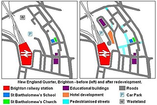
The New England Quarter is a mixed-use development in the city of Brighton and Hove, England. It was built between 2004 and 2008 on the largest brownfield site in the city, adjacent to Brighton railway station. Most parts of the scheme have been finished, but other sections are still being built and one major aspect of the original plan was refused planning permission.

West One is a mixed-use development at the centre of the Devonshire Quarter in the city centre of Sheffield, South Yorkshire, England. It comprises bars, restaurants and shops at ground-level and apartments housing over 1,000 people above, including a penthouse. It faces onto Devonshire Green, and provides easy access to the Moor and Division Street.

Division Street is a street and shopping area located in the Devonshire Quarter of Sheffield, England. It is home to many small independent shops, a few large ones such as Costa Coffee and Sainsburys Local, and a few local pubs such as the Frog & Parrot, as well as a Lloyd's No. 1 bar. It runs parallel to West Street in the west of the city.

Pinstone Street is a part-pedestrianised road located in Sheffield, England. It connects the two main shopping areas of Fargate and The Moor in the centre of the city.
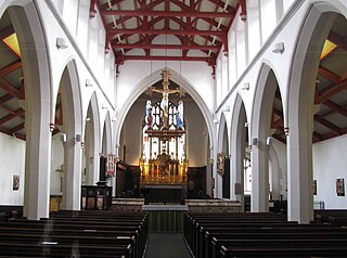
St Matthew's Church, more usually known as St Matthew's Carver Street, is situated on Carver Street in the centre of Sheffield, South Yorkshire, England. It is a Grade II listed building located at grid reference SK351871. The church is part of the Anglo-Catholic movement.
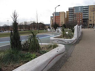
Devonshire Green is a small public open space at 53.3789°N 1.4783°W within Sheffield city centre in South Yorkshire, England. It covers an area of approximately 9000 square metres and is designated as a district park by Sheffield City Council. It stands in the Devonshire Quarter of the city centre, bordered on its four sides by Devonshire Street, Fitzwilliam Street, Eldon Street and Wellington Street. It is the only large green space in the city centre.

Taylor's Eye Witness Works is an industrial building on Milton Street in the Devonshire Quarter area of Sheffield city centre, South Yorkshire, England. The works are a Grade II listed building which since their foundation in 1852 have always specialised in producing kitchen and pocket knives along with various associated products. The building is believed to be the only traditional works in Sheffield which still manufactures its original products. It stands next to the Beehive Works another listed cutlery works on Milton Street.

Kingswood, occasionally referred to as Kingswood Parks, is a modern housing estate on the northern fringe of Kingston upon Hull, England.
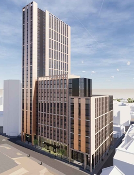
Code Sheffield is an under-construction skyscraper located at the junction of Wellington Street and Rockingham Street in Sheffield, South Yorkshire. Construction commenced in March 2022 as part of the Heart of the City 2 redevelopment of this area of the city centre. With an originally planned height of 117 metres (384 ft) once completed, Code Sheffield would have overtaken both the St Paul's Tower as the tallest building in Sheffield and Altus House in Leeds as the tallest building in Yorkshire. However, due to rising costs the planned height of the building was reduced from 38 to 26 storeys.


