Arundel Gate

Last updated

A view down Arundel Gate in August 2009, looking northwards towards Castle Square, with the Crucible Theatre on the left and O2 Academy Sheffield on the right. Arundel Gate.jpg
A view down Arundel Gate in August 2009, looking northwards towards Castle Square, with the Crucible Theatre on the left and O2 Academy Sheffield on the right.

Arundel Gate is one of the main thoroughfares in Sheffield, England. It is located in the Heart of the City area of Sheffield City Centre. Arundel Gate also features a fifteen-stand bus station, including a ticket office building, completed in 2005.

Contents

Arundel Gate is 0.5 mi (0.8 km) long, running through the eastern side of the city centre. It starts as a continuation of the Eyre Street dual carriageway from the Furnival Square roundabout where it meets Furnival Gate and Furnival Street. Arundel Gate initially heads northeast as a dual carriageway, before turning north at Hallam Square and becoming a single carriageway. Continuing northwards, Arundel Gate becomes a dual carriageway again shortly before terminating at Castle Square, the junction with High Street, continuing onwards as Angel Street.

Two conservation areas have been designated by Sheffield City Council in the areas surrounding Arundel Gate. These are the City Centre Conservation Area which covers an area of 0.12 sq mi (0.3 km2) on the western side of Arundel Gate, [1] and the Cultural Industries Quarter Convervation Area on the eastern side of the road. [2]


Notable buildings

The brutalist complex in 2008, with the O2 Academy on the left and Odeon on the right. Arundel Gate from the top of the Lyceum theatre - geograph.org.uk - 783622.jpg
The brutalist complex in 2008, with the O2 Academy on the left and Odeon on the right.

A number of Sheffield's most prominent landmarks are located along Arundel Gate. St Paul's Tower, the tallest building in the city at 101 m (331 ft) tall, and the adjacent "Cheesegrater" car park were both completed in 2011, fronting onto Arundel Gate as part of the St Paul's Place redevelopment. The Millennium Gallery, opened in 2001, also features an entrance onto Arundel Gate. Tudor Square is located next to Arundel Gate near its northern end; the square includes the Crucible Theatre, the venue for the annual World Snooker Championship, as well as the Central Library, Lyceum Theatre, Studio Theatre and Winter Gardens.

Opposite Tudor Square is a large brutalist structure built into the steep hillside between Arundel Gate and Pond Street in the 1970s. The structure is home to the O2 Academy Sheffield, a music venue which opened in 2008; it had previously been the Roxy's nightclub. Next to the O2 Academy is Odeon Sheffield, a seven-screen cinema opened on the site of the former Fiesta nightclub in 1992. In December 2018, the Odeon was reopened as an Odeon Luxe cinema after a refurbishment. A small underground nightclub, Tank, is located next to the cinema. Running underneath the entire O2 Academy and Odeon structure is a multi-storey car park, accessed from the top via an underpass from Arundel Gate or from the bottom on Flat Street, opposite Sheffield Interchange; it is operated by National Car Parks.

Hallam Square is a pedestrianised public square adjoining onto Arundel Gate to the south of the brutalist complex mentioned above. Several buildings of Sheffield Hallam University's City Campus front onto Arundel Gate around Hallam Square, leading down Howard Street.

Arundel Gate Interchange

Arundel Gate Interchange
Sheffield, Arundel Gate Interchange - geograph.org.uk - 1291978.jpg
General information
Location30 Arundel Gate, Sheffield City Centre
Sheffield (S1 2PP)
England
Owned by South Yorkshire Passenger Transport Executive
Operated bySouth Yorkshire Passenger Transport Executive
Bus stands15
Bus operators First South Yorkshire, Powell's Bus, Stagecoach Yorkshire, TM Travel
Connections Castle Square tram stop Supertram generic logo.PNG
Sheffield Interchange BSicon BUS2.svg
Sheffield railway station National Rail logo.svg Supertram generic logo.PNG
Construction
ParkingYes (National Car Parks)
Bicycle facilitiesYes
AccessibleYes
History
Opened2005 (ticket office)

Arundel Gate Interchange is a linear bus station located along both sides of Arundel Gate at its northern end, between Castle Square and Hallam Square. [3] It is one of two Travel South Yorkshire Interchanges located in Sheffield City Centre, along with the main bus station at Sheffield Interchange located 150 m (490 ft) to the east on Pond Street. As well as Sheffield Interchange, further onward connections are available from Castle Square tram stop on the Sheffield Supertram network, located at the northern end of Arundel Gate; and from Sheffield station, located beyond Sheffield Interchange.

As well as fifteen roadside bus stops, there is a small Travel South Yorkshire ticket office building located at 30 Arundel Gate, in the middle of the triangle junction between Arundel Gate, Norfolk Street and Milk Street. It is a small triangular building constructed primarily of a blue metal frame with large floor-to-ceiling windows, located directly next to the Crucible Theatre. The ticket office was opened in 2005, originally featuring staffed ticket desks and paper timetable stands. As of 2021, the staffed ticket desks remain, although the paper timetables have now been replaced by automated electronic ticket machines for issuing products onto Travel South Yorkshire smartcards; paper timetables are no longer produced. The ticket office is staffed from 07:00 to 19:00 from Monday to Saturday, and does not open on Sundays. There is also a free-to-use disability-accessible public toilet located on the outside of the building which is available to use 24 hours a day.

A refurbishment project to link Arundel Gate Interchange and Sheffield Interchange commenced in 2018 and was completed in 2020. The project featured the demolition of a row of shops on Arundel Gate, the pedestrianisation of Esperanto Place and Fitzalan Square and widening of pedestrian walkways along Flat Street and Pond Street, and the creation of a new pedestrian link between the cul-de-sac of Esperanto Place and Arundel Gate at the site of the demolished shop buildings. This project created a new high-quality walkway between the two bus stations.

In response to the COVID-19 pandemic in the United Kingdom, temporary changes were made to Arundel Gate Interchange in order to allow for more effective social distancing at peak times. To reduce overcrowding at existing bus stops, two new bus stops were opened on the southbound side of Arundel Gate. These new bus stops were numbered AG123 and AG124; this temporary numbering scheme in the hundreds follows on from other temporary bus stops installed across Sheffield City Centre in response to the pandemic, rather than the numbering system of the existing permanent bus stops at Arundel Gate. Additionally, the roadway at Arundel Gate was reduced from three lanes wide in the northbound direction to two, allowing the pavement to be widened to increase available pedestrian space at the existing bus stops. [4]

Services

Bus stops AG1 to AG8 and AG11 are located on the northbound side of Arundel Gate; all of the others are located on the southbound side of the road, including temporary bus stops AG123 and AG124.

As of March 2024, the stand allocation is: [5]

StandRouteDestination
AG141 Dyke Vale Road     
120 Halfway Supertram generic logo.PNG     
AG230, 30a Plumbley     
52, 52a Woodhouse National Rail logo.svg     
80, 80a Chesterfield BSicon BUS2.svg     
X30 Harthill     
AG3
24, 25 Woodhouse National Rail logo.svg     
AG41, 1a High Green     
88 Ecclesfield     
AG575, 76 Shiregreen     
AG620 Ecclesfield     
83 Ecclesfield     
97, 98 Hillsborough Supertram generic logo.PNG BSicon BUS2.svg     
X1, X2 Maltby     
AG75 Firth Park     
7, 8 Ecclesfield     
AG881, 82 Stannington     
86 Chapeltown National Rail logo.svg     
252 Crystal Peaks Supertram generic logo.PNG BSicon BUS2.svg     
AG9
20 Hemsworth     
via Heeley and Norton (First)
24, 25 Bradway     
AG1043, 44 Chesterfield BSicon BUS2.svg     
AG116 Millhouses     
51 Lodge Moor     
AG125 Sheffield, Moor Market BSicon BUS2.svg     
X17 Matlock BSicon BUS2.svg     
AG131, 1a, 11 Herdings Park Supertram generic logo.PNG     
80, 80a Sheffield, Moor Market BSicon BUS2.svg     
X1, X2 Sheffield, Moor Market BSicon BUS2.svg     
AG12375, 76, 76a Lowedges     
86 Lowedges     
97, 98 Totley Brook     
AG12481, 82 Dore     
83 Fulwood     
88 Bents Green     

See also

Related Research Articles

<span class="mw-page-title-main">Sheffield</span> City in South Yorkshire, England

Sheffield is a city in South Yorkshire, England, whose name derives from the River Sheaf which runs through it. The city serves as the administrative centre of the City of Sheffield. It is historically part of the West Riding of Yorkshire and some of its southern suburbs were transferred from Derbyshire to the city council. It is the largest settlement in South Yorkshire.

<span class="mw-page-title-main">South Yorkshire Supertram</span> Light rail system in South Yorkshire, England

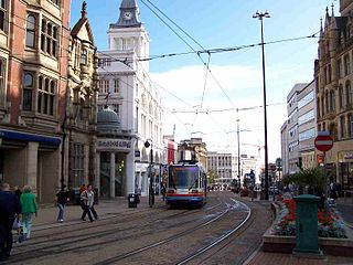
The South Yorkshire Supertram, sometimes referred to as the Sheffield Supertram, is a tram and tram-train network covering Sheffield and Rotherham in South Yorkshire, England. The network is owned and operated by the South Yorkshire Mayoral Combined Authority (SYMCA).

<span class="mw-page-title-main">Sheffield station</span> Combined railway station and tram stop in Sheffield, England

Sheffield station is a combined railway station and tram stop in Sheffield, England; it is the busiest station in South Yorkshire, and the third busiest in Yorkshire & the Humber. Adjacent is Sheffield station/Sheffield Hallam University Sheffield Supertram stop.
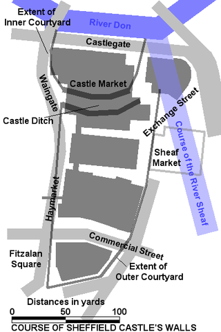
<span class="mw-page-title-main">Leeds railway station</span> Mainline railway station in Leeds, West Yorkshire, England

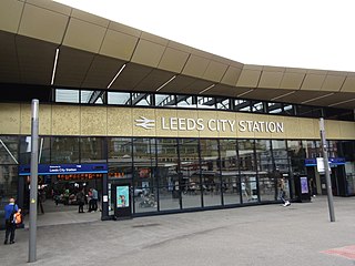
Leeds railway station is the mainline railway station serving the city centre of Leeds in West Yorkshire, England. It is located on New Station Street to the south of City Square, at the foot of Park Row, behind the landmark Queens Hotel. It is one of 20 stations managed by Network Rail. As of December 2023, it was the busiest station in West Yorkshire, as well as in Yorkshire & the Humber, and the entirety of Northern England. It is the second busiest station in the UK outside of London, after Birmingham New Street.

<span class="mw-page-title-main">Mexborough</span> Town in South Yorkshire, England

Mexborough is a town in the City of Doncaster in South Yorkshire, England. Situated between Manvers and Denaby Main, it lies on the River Don close to where it joins the River Dearne, and the A6023 road runs through the town. It is contiguous with the town of Swinton which is directly to the southwest immediately across the railway and Conisbrough to the east.

<span class="mw-page-title-main">Meadowhall Interchange</span> Transport interchange serving Meadowhall shopping centre in Sheffield, South Yorkshire, England

Meadowhall Interchange is a transport interchange located in north-east Sheffield, consisting of a combined heavy rail station, tram stop and bus and coach station. The second-busiest heavy rail station in the city in terms of passenger numbers, Meadowhall Interchange provides connections between National Rail services, the Sheffield Supertram light rail network, intercity coach services and the city bus network.

<span class="mw-page-title-main">Castle Square, Sheffield</span>

Castle Square is the plaza at the intersection of High Street, Angel Street, and Arundel Gate in the City of Sheffield, England. This name was given to the square in the 1960s to reflect the proximity of the square to the site of Sheffield Castle, which was formerly located a short distance to the north-east.

<span class="mw-page-title-main">Barnsley Interchange</span> Railway station in South Yorkshire, England

Barnsley Interchange is a combined rail and bus station in the centre of Barnsley, South Yorkshire. It was first opened in 1850 as Barnsley Exchange railway station and is 16 miles (26 km) north of Sheffield. It is on the Hallam and Penistone Lines, both operated by Northern Trains. On 20 May 2007, the new bus station and refurbished railway station were officially opened by Travel South Yorkshire, with the combined facility renamed to Barnsley Interchange.

<span class="mw-page-title-main">Sheffield Interchange</span> Bus station in Sheffield, South Yorkshire, England

Sheffield Interchange is the main bus station in central Sheffield, South Yorkshire, England. The facility is served by buses operating across the Sheffield region, as well as National Express coaches that connect Sheffield with destinations across the United Kingdom.

<span class="mw-page-title-main">South Yorkshire Passenger Transport Executive</span>

South Yorkshire Passenger Transport Executive (SYPTE) was the passenger transport executive for South Yorkshire. It was responsible for public transport policies, infrastructure and operation from its formation in 1974 until its dissolution in 2023, when its assets and duties were transferred to the South Yorkshire Mayoral Combined Authority.

<span class="mw-page-title-main">Cultural Industries Quarter</span> District in Sheffield, England

The Cultural Industries Quarter is a district in the city centre of Sheffield, England, and one of the eleven Quarters designated in the 1994 City Centre Strategy. It is roughly triangular in shape, and is bound by Howard Street, Sheaf Square and Suffolk Road to the north-east, St Mary's Road to the south and Eyre Street and Arundel Gate to the north-west, with Granville Square in the south-east. The name given reflects the intention to create a cluster of music, film and science-based businesses in the area.

<span class="mw-page-title-main">Sheffield City Centre</span> Central business district in South Yorkshire, England

Sheffield City Centre is a district of the City of Sheffield and is covered partly by the City ward of the City of Sheffield. It includes the area that is within a radius of roughly 0.75 miles (1.2 km) of Sheffield Cathedral and is encircled by the Inner Ring Road, a circular route started in the late 1960s and completed in 2007. As well as the cathedral, buildings in the city centre include the Grade I listed Town Hall, the City Hall and the Winter Gardens. Several areas of the city centre have been designated as quarters. It is home to the city's major business, transport, leisure and cultural attractions.

<span class="mw-page-title-main">High Street, Sheffield</span>

High Street is one of the main thoroughfares and shopping areas in the city centre of Sheffield in South Yorkshire, England, located at the approximate grid reference of SK356874. High Street starts at the Commercial Street, Fitzalan Square and Haymarket junction and runs for approximately 400 metres west to conclude near the Sheffield Cathedral where it forms a Y-junction with Fargate and Church Street. High Street has the traditional wide variety of shops, financial institutions and eating places which are associated with any British town centre.

<span class="mw-page-title-main">Castlegate Quarter</span>

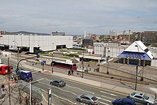
The Castlegate Quarter is one of the eleven quarters of Sheffield city centre. It is named after Castlegate, the quarter's main thoroughfare. The boundaries of the Castlegate Quarter are formed by Castlegate and the River Don to the north, Exchange Place to the east, Commercial Street and part of the High Street to the south, and Angel Street and Snig Hill to the west. For the latter part of the 20th century, the Castlegate Quarter was dominated by Castle Market, a large indoor market building. Following the demolition of Castle Market in 2015, the quarter is now undergoing regeneration as of 2020.

<span class="mw-page-title-main">Rotherham Interchange</span>

Rotherham Interchange is a bus station serving the town of Rotherham, South Yorkshire. It consists of 24 bus stands located inside the main Interchange building in Rotherham town centre, next to the College Walk shopping centre which leads out onto Frederick Street. It is the main hub for bus services in the Rotherham area, and is located a short walk over the Chantry Bridge over the River Don from Rotherham Central station on the National Rail and Sheffield Supertram networks.

<span class="mw-page-title-main">Hillsborough Interchange</span>

Hillsborough Interchange is a bus and tram interchange in Hillsborough, Sheffield. It serves a variety of operators including First South Yorkshire,Sheffield Supertram and Stagecoach Yorkshire, South Pennine Community Transport. It is staffed between 07:00 and 19:00 Monday to Saturday and has six bus stands and two tram platforms.

<span class="mw-page-title-main">Odeon Sheffield</span> Multiplex cinema in Sheffield, South Yorkshire, England

Odeon Sheffield is a multiplex cinema located at Arundel Gate in Sheffield city centre, South Yorkshire, England, adjacent to the city's O2 Academy.

<span class="mw-page-title-main">South Yorkshire Mayoral Combined Authority</span> Local government body for South Yorkshire, England

The South Yorkshire Mayoral Combined Authority is the combined authority for South Yorkshire in England, with powers over transport, economic development and regeneration. It covers a total area of 3,484 km2 (1,345 sq mi) with a population of 1.8 million. The four metropolitan boroughs of South Yorkshire – Sheffield, Rotherham, Doncaster and Barnsley – are full members of the authority, while the Derbyshire Dales, North East Derbyshire, Chesterfield and Bolsover districts of Derbyshire, and the Bassetlaw district of Nottinghamshire, are non-constituent members.

<span class="mw-page-title-main">Kings Tower, Sheffield</span> Future residential skyscraper in Sheffield, England

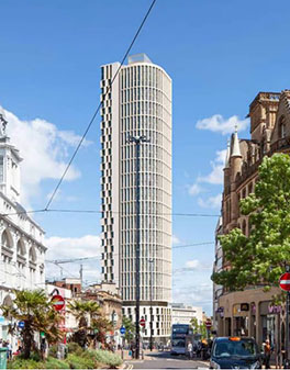
Kings Tower is an approved skyscraper that will be located on Castle Square at the junction of High Street and Angel Street in Sheffield, South Yorkshire. With a planned height of 120 m (390 ft) once completed, Kings Tower will overtake Code Sheffield, and St Pauls Tower as the tallest building in Sheffield and in Yorkshire. Plans for the tower were submitted by architects Hodder + Partners in September 2020, calling initially for a 39-storey tower. Planning permission was granted in December 2020, and construction is planned to complete in 2023. Amended plans were submitted in late 2022, adding a 40th floor to the project.

Public transport in South Yorkshire, England mainly consists of three modes: bus, tram and train.

References

  1. "City Centre Conservation Area". Sheffield City Council.
  2. "Cultural Industries Quarter Conservation Area". Sheffield City Council.
  3. "Bus Interchanges". Travel South Yorkshire.
  4. "Covid-19: Temporary changes to footpaths and highways". Sheffield City Council.
  5. "Arundel Gate live departures board". Travel South Yorkshire.