
North East Derbyshire is a local government district in Derbyshire, England. The council is based in the large village of Wingerworth. The district also includes the towns of Dronfield and Clay Cross as well as numerous villages and surrounding rural areas.

The Moss is a brook in North East Derbyshire, England.

Eckington is a town and civil parish in North East Derbyshire, England. It is 7 miles (11 km) northeast of Chesterfield and 9 miles (14 km) southeast of Sheffield, on the border with South Yorkshire. It lies on the B6052 and B6056 roads close to the A6135 for Sheffield and Junction 30 of the M1. It had a 2001 population of 11,152, increasing to 11,855 at the 2011 Census.

Hackenthorpe is a village 5 miles south east of Sheffield’s city centre, now classed as a historic township of the city. Due to much expansion, the village became a part of Sheffield city during the 1950s. During much of the late 19th and 20th centuries the village was noted for its steelmaking, with the Thomas Staniforth & Co Sickle works being based at Main Street. Another prominent feature of the village is the 17th century Hackenthorpe Hall, built by John Newbould for the Hounsfield family, with James Hounsfield being a prominent land owner. The building is today used as a nursery.

Mosborough is an electoral ward of the City of Sheffield, England, in the eastern part of the city, on the border with North East Derbyshire District. The population in 2011 was 17,097. It is one of the wards that make up the Sheffield South East constituency.
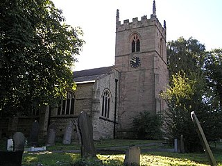
Killamarsh is a village and civil parish in North East Derbyshire, England, bordering Rotherham to the north and Sheffield to the north-west. It lies close to Derbyshire’s border with South Yorkshire.

The Sheffield & Tinsley Canal is a canal in the City of Sheffield, England. It runs 3.9 miles (6.3 km) from Tinsley, where it leaves the River Don, to the Sheffield Canal Basin in the city centre, passing through 11 locks. The maximum craft length that can navigate this lock system is 61 feet 6 inches (18.75 m) with a beam of 15 feet 6 inches (4.72 m).
Sheffield is a geographically diverse city in England. It nestles in the eastern foothills of the Pennines and the confluence of five rivers: Don, Sheaf, Rivelin, Loxley and Porter. As such, much of the city is built on hillsides, with views into the city centre or out to the countryside. The city is roughly one third urban, one third rural and one third in the Peak District. At its lowest point the city stands just 29 metres above sea level at Blackburn Meadows on the Rotherham border, rising up to over 500 m in some parts of the city to a peak of 548m at High Stones on the Derbyshire border; however, 89% of the housing in the city is between 100 and 200 metres above sea level. Over 95% of the population resides in the main urban area.

The Sheffield Urban Area is a conurbation in the north of England with a population of 685,368 according to the 2011 census. This was a 7% increase on the 2001 population of 640,720 making it the 8th largest conurbation in the United Kingdom and England's 6th largest. Named the Sheffield Urban Area by the Office for National Statistics, it must not be confused with the Sheffield City Region, a non-government term, although often used, particularly by the business community. In 2001 the population density of the urban area was 3,949.2 people per km2 by 2011 this had increased slightly to 4,092 people per km2.

Ridgeway is a village in Eckington parish, North East Derbyshire in the English county of Derbyshire.

Coal Aston is a village in the civil parish of Dronfield, in the North East Derbyshire district, in the county of Derbyshire, England. It is by the town of Dronfield.

Westfield School, is a mixed secondary school located in Sheffield, South Yorkshire, England. On 1 December 2018 it joined Chorus Education Trust, a local multi-academy trust founded by Silverdale School in Sheffield. The school was a specialist Sports College but removed this title from the name in June 2013. It serves an area on the south east edge of Sheffield where many people now work in service industries and where levels of prosperity range from above to below average.
Eckington School is a coeducational secondary school and sixth form located in Eckington, Derbyshire in England, next to the B6056 road. It has around 1,250 pupils. The school is an academy, and is part of the Chorus Education Trust.

Shire Brook is a small stream in the south eastern part of the City of Sheffield in South Yorkshire, England. It rises in the suburb of Gleadless Townend and flows in a general easterly direction for 4 miles (6.5 km) to its confluence with the River Rother between Beighton and Woodhouse Mill. In the past the brook has been both the border of Yorkshire and Derbyshire and between the sees of Canterbury and York. The course of the stream has been influenced by human intervention in the 20th century with the brook being diverted underground and flowing through culverts on three occasions as it traverses locations which were formerly landfill sites and extensive railway sidings.
Troway is a hamlet in North East Derbyshire, England. Population details are included in the civil parish of Eckington. Troway is located in the Moss Valley, on both banks of the Troway Brook and its tributary the Vale Brook. The Troway Brook flows into The Moss near the hamlets of Birley Hay and Ford. In 2007, some major damage to houses in Troway was caused after the Troway Brook burst its banks.

Beighton is a village 6½ miles south-east of Sheffield's city centre, now classed as a historic township of the city. Due to much expansion, the village became a part of Sheffield city in 1967, and was transferred from Derbyshire to the newly created South Yorkshire, England. During much of the late 17th to 19th centuries the village was noted for its edge tool manufacturing, with Thomas Staniforth & Co Sickle works being based at nearby Hackenthorpe.

Mosborough is a village in the City of Sheffield in South Yorkshire, England. Historically part of Derbyshire, the village was named after The Moss river which flows through the village. During the late 19th century and 20th century, the village was noted for its steelmaking, with Hutton & Co. Sickle works being based at nearby Ridgeway. The village expanded due to developments in nearby Owlthorpe, Westfields and Waterthorpe. Mosborough, which was a township at the time, was transferred from Derbyshire to the West Riding of Yorkshire as part of Sheffield.
The Ochre Dyke is a small stream in the south eastern part of the City of Sheffield in South Yorkshire, England. It rises some 100m to the east/south east of the ruined barn known as Eckington Lees. This is at the extreme western end of Birley Wood Golf Course. Ochre Dyke flows east/south east along the southern border of the golf course and passes through Birley Wood; up to this point it is the county boundary between South Yorkshire and North East Derbyshire. During summer months the brook frequently dries up to this point. The Ochre dyke gets its name from the pollution of the water by yellow ochre as a result of coal mining activity in the upper reaches of the valley. The area in and around Birley wood was extensively mined for coal and black-band iron ore from at least the medieval period up to the mid 20th century when Dent Main Colliery closed. Other mines along the course of the stream were Moorhole Colliery East, Moorhole Colliery North and Moorhole Colliery South.

Eckington Cemetery is a cemetery in Eckington, Derbyshire, England. The cemetery serves Eckington itself, as well as nearby villages such as Renishaw, Ridgeway, Spinkhill, Troway and Marsh Lane, Derbyshire. The cemetery features a number of Commonwealth War Graves.

Burbage Edge is a gritstone escarpment overlooking the Burbage district of Buxton in Derbyshire, in the Peak District. The hill's summit is 500 metres (1,600 ft) above sea level.

