Masbrough

Last updated

Masbrough
Rotherham Roundwalk towards Fenton Road (geograph 4197963).jpg
The tree and fern-surrounded section of the Rotherham Round Walk, a rural trail, within Masbrough
South Yorkshire UK location map.svg
Red pog.svg
Masbrough
Location within South Yorkshire
Area5.78 km2 (2.23 sq mi)
Population13,262 (2011 census, including the Richmond Park neighbourhood and part of Kimberworth) [1]
  Density 2,294/km2 (5,940/sq mi)
Metropolitan borough
Metropolitan county
Region
Country England
Sovereign state United Kingdom
Post town ROTHERHAM
Postcode district S60
Dialling code 01709
Police South Yorkshire
Fire South Yorkshire
Ambulance Yorkshire
UK Parliament
List of places
UK
England
Yorkshire
53°25′48″N1°22′23″W / 53.430°N 1.373°W / 53.430; -1.373 Coordinates: 53°25′48″N1°22′23″W / 53.430°N 1.373°W / 53.430; -1.373

Masbrough is a suburb of Rotherham, South Yorkshire, England. It was named as the west of Rotherham by the middle of the Industrial Revolution, namely that part on the left bank of Don. Historically part of the West Riding of Yorkshire, it is in the Metropolitan Borough of Rotherham, centred 0.5 miles (0.8 km) west of Rotherham town centre. Much of the suburb falls within the Rotherham West ward of Rotherham MBC.

Contents

History and landmarks

This was the Guest & Chrimes valve works. Replaced by an office block by the River Don, this tall red brick building with arched windows stood before 2010, built in the nineteenth or early 20th century. Industrial revolution grandeur (geograph 2252776).jpg
This was the Guest & Chrimes valve works. Replaced by an office block by the River Don, this tall red brick building with arched windows stood before 2010, built in the nineteenth or early 20th century.

Part of its land in the north lay within the manor of Kimberworth, the other contiguous western suburb of Rotherham today – Masbrough did not feature in the Domesday Book survey of 1086.

Masbrough, in the township of Kimberworth, parish and union of Rotherham... ½ a mile (N. W.) from Rotherham; containing nearly 5000 inhabitants. This place forms part of the suburbs of the town of Rotherham, with which it is connected by [a bridge, the Chapel of Our Lady of Rotherham Bridge] of five pointed arches over the river Don, on the central pier of which is an ancient chapel of elegant design, [then] used as a prison. It is nearly of equal extent...and has long been distinguished as the [site] of numerous works connected with the manufactures of the district; of these, a few years since, the principal were the extensive foundry and iron-works of the late Samuel Walker, Esq., in which, during the war, immense quantities of cannon and ordnance of the largest calibre were cast, and subsequently, various iron bridges, including that of Southwark in London. Since the establishment here of a station of the Midland railway, by which... sheep and cattle are sent to Manchester, Liverpool, and other towns, a wonderful increase has taken place in the value of landed property; and the facility of [travel to] distant parts... by that line... promises to render this a principal seat of manufacture. It also derives benefit from the Sheffield and Rotherham branch railway. A large tract of land, forming the estate of Benjamin Badger... has been surveyed and laid out in lots for building; and several streets, intersecting each other at right angles, and forming direct approaches from Rotherham and the neighbourhood to the railway station, have been marked out. A spacious hotel for the accommodation of passengers by the railway, and some handsome dwelling-houses, have been built; and a great increase has been made in the number of manufacturing establishments: there are potteries, glass-works, chemical works, a timber-yard, and several forges and foundries. The Independent College, noticed under the head of Rotherham, is... here; and a Roman Catholic chapel has been built. – Extract from A Topographical Dictionary of England, Samuel Lewis (publisher), 1848

A commemorative memorial to 50 victims of a boat disaster at Masbrough in 1841 by Edwin Smith of Sheffield is in All Saints Church, Rotherham. [2]

Legacies

A large memorial to a celebrated iron magnate, Samuel Walker, stands behind the site once occupied by the 1760 Independent chapel (with a date stone of 1777), the Walker Mausoleum. After being closed as a place of worship, the chapel became a carpet showroom Allens of Rotherham, but was destroyed by fire in 2012. It is connected by a short foot subway and Chapel Walk to all the historic buildings in central Rotherham. [3] There were further memorials and statues within the chapel building. [4] The chapel's statue to Jonathan Walker (died 1807), who was at the heart of the iron industry that led to the local area's development, depicts the man leaning on a truncated column "with head in hand". [5]

In 1862, the Midland Iron Company was the scene of an industrial disaster, when one of the boilers exploded, killing nine people. No trace of this company exists as it became the site of a new bus depot in 1982.

Schools

The Masbrough community is served by Thornhill and Ferham primary schools. Secondary schooling is provided by Winterhill School in nearby Kimberworth.

Places of worship

Masbrough has six places of worship: St Bede's Roman Catholic Church, St Paul's Church of England Church, and Rotherham Assemblies of God, now known as Liberty Church, Rotherham, and the Jamia Mosque in College Road and two other mosques for Sunni Muslims.

Demography

Avondale Street and adjoining streets Avondale Street - geograph.org.uk - 1570521.jpg
Avondale Street and adjoining streets

The electoral ward largely co-extensive with Masbrough has lately been named Rotherham West. Respondents in this ward to the 2011 Census mainly identified themselves ethnically as White British, White European or British Pakistani.

People in this ward born in non-UK EU countries numbered approximately 5 per cent of the population: 572 (of which Ireland 35). Residents born in South Asia numbered 591, the Middle East 77, Zimbabwe 69, and Central and Western Africa 60. The dense minorities communities in the ward are due to the affordability of local housing.

2011 Published Statistics: Population, home ownership and extracts from Physical Environment, surveyed in 2005 [1]
Output areaHomes owned outrightOwned with a loanSocially rentedPrivately rentedOtherkm² green space (includes two outlying farms, central parks and playing fields)km² roadskm² waterkm² domestic gardenskm² domestic buildingskm² non-domestic buildingsUsual residentskm²
'Rotherham West' Ward1,4641,6161,3918641242.930.620.070.860.300.3113,2625.78

Sport

Masbrough is the home of Millmoor, the former stadium of Second Division football club, Rotherham United and less than 0.5 miles (0.8 km) west from its replacement across the riverside nature reserve.

Transport

Rotherham Masborough railway station closed, having been opened in 1840 by the North Midland Railway as an interchange with the Sheffield and Rotherham Railway. Its services were diverted in 1987 to a new Rotherham Central railway station on a parallel line 600 m to the east.

The M1 motorway passes, at junction 34, Meadowhall, the far western neighbourhood of Masbrough, which is associated with Kimberworth.

Notable people

Related Research Articles

Kimberworth Suburb of Rotherham, South Yorkshire, England

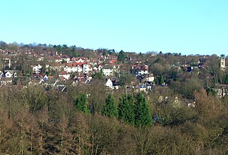
Kimberworth is a suburb of Rotherham, South Yorkshire, England. It is located in the Metropolitan Borough of Rotherham, about 2.2 miles (3.5 km) north west of Rotherham town centre and 4.7 miles (7.6 km) north-east of the City of Sheffield.

Ecclesfield Village and civil parish in South Yorkshire, England

Ecclesfield is a village and civil parish in the City of Sheffield, South Yorkshire, England, about 4 miles (6 km) north of Sheffield City Centre. Ecclesfield civil parish had a population of 32,073 at the 2011 Census. Ecclesfield wards of the City of Sheffield had a population of 35,994 in 2011. The population of Ecclesfield village stood at 7,163 in the most recent census.

Millhouses Neighbourhood in Sheffield, England

Millhouses is a neighbourhood in the City of Sheffield, England. It is located in Ecclesall ward; in the south-western portion of the city on the northwest bank of the River Sheaf. Its origins lie in a small hamlet that grew around the Ecclesall Corn Mill. It has a population of 4,424.

Ladys Bridge

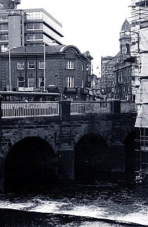
Lady's Bridge is the oldest bridge across the River Don in the City of Sheffield, England. It is located in the central section of the city, linking the Wicker to the north with Waingate to the south.

Treeton Village and civil parish in South Yorkshire, England

Treeton is a village and civil parish of the Metropolitan Borough of Rotherham in South Yorkshire, England. It is located about 4 miles (6 km) south of the town of Rotherham and 5 miles (8 km) east of Sheffield City Centre.

Burngreave (ward) Electoral ward in the City of Sheffield, South Yorkshire, England

Burngreave ward—which includes the districts of Burngreave, Fir Vale, Grimesthorpe, Pitsmoor, and Shirecliffe—is one of the 28 electoral wards in City of Sheffield, England. It is located in the northern part of the city and covers an area of 2.8 square miles. The population of this ward in 2011 was 27,481 people in 9,906 households. It is one of the wards that make up the Sheffield, Brightside and Hillsborough constituency. Most of the ward is served by a free community newspaper, the Burngreave Messenger.

North Midland Railway

The North Midland Railway was a British railway company, which opened its line from Derby to Rotherham (Masbrough) and Leeds in 1840.

Sheffield and Rotherham Railway

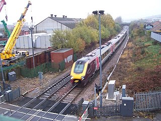
The Sheffield and Rotherham Railway was a short railway in England, between Sheffield and Rotherham and the first in the two towns.

Rotherham Westgate railway station

Rotherham Westgate railway station was the eastern terminus of the five-mile-long Sheffield and Rotherham Railway, the first passenger-carrying railway in the Sheffield/Rotherham area. In central Rotherham on the eastern bank of the River Don, it was a single-platform terminus that opened on 31 October 1838 and closed on 4 October 1952.

Rotherham Masborough railway station Disused railway station in South Yorkshire, England

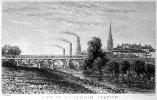
Rotherham Masborough railway station was the main railway station for Rotherham, South Yorkshire, England from the 1840s until 1987, when most trains were rerouted via Rotherham Central. It had four platforms, with a large sandstone station building on the eastern Platform Four, large iron and glass platform canopies, a fully enclosed footbridge and wooden waiting rooms on the other platforms. It closed in 1988, except for a few football specials.

This timeline of Sheffield history summarises key events in the history of Sheffield, a city in England. The origins of the city can be traced back to the founding of a settlement in a clearing beside the River Sheaf in the second half of the 1st millennium AD. The area had seen human occupation since at least the last ice age, but significant growth in the settlements that are now incorporated into the city did not occur until the industrial revolution.

Greasbrough Suburb of Rotherham, South Yorkshire, England

Greasbrough is a small suburb in Rotherham, in South Yorkshire, England. The suburb falls in the Wingfield Ward of Rotherham Metropolitan Borough Council. Greasbrough had its own local council, Greasbrough UDC, until its absorption into the County Borough of Rotherham in 1936.

Holmes railway station Disused railway station in South Yorkshire, England

Holmes railway station was a railway station in Rotherham, South Yorkshire, England. The station served the communities of Masbrough and Holmes and was situated on the former Sheffield and Rotherham Railway (S&R) line between Rotherham Westgate Station and Wincobank and Meadowhall Station. The station, which had two flanking platforms, opened with the line.

Rawmarsh Village in South Yorkshire, England

Rawmarsh is a large village in the Metropolitan Borough of Rotherham, in South Yorkshire, England. Historically within the West Riding of Yorkshire, it is 2 miles (3 km) north-northeast from Rotherham town centre and 3 miles (5 km) south-southwest of Swinton. The village also forms part of the Sheffield Urban Area. The Rawmarsh ward of Rotherham MBC had a population of 13,389 at the 2011 Census. Rawmarsh also contains other output areas from neighbouring wards giving it a population of 18,498 in 2011 and 18,535 in 2014.

Rotherham Town in South Yorkshire, England

Rotherham is a large minster town in South Yorkshire, England. It is the main settlement in the Metropolitan Borough of Rotherham. Located on the traditional road between Sheffield and Doncaster. The Rother merges with the River Don. The Don then flows through the town centre.

The Walker Mausoleum is located at 53.4313°N 1.3655°W on College Road, Rotherham, South Yorkshire, England. The sandstone mausoleum was built in the 1760s as the burial site for the families of Samuel and Aaron Walker and is now a Grade II listed building.

The Masbrough boat disaster was a disaster that occurred in a boatyard on the River Don in Masbrough, Yorkshire, now a suburb of Rotherham, on 5 July 1841. The disaster occurred during the launching of a new boat: sixty-four people, mainly children were drowned in the river.

The Masbrough Independent Chapel was an Independent or Congregationalist chapel in the Masbrough district of Rotherham, from the 18th century until the 1970s, at which point it became part of the United Reformed Church.

Fulwood, Sheffield Suburb of Sheffield in South Yorkshire, England

Fulwood is a residential suburb and ward of the City of Sheffield in England, it lies 5.5 km west-southwest of the city centre. Formerly an ancient settlement and village on the Porter Brook, it became integrated into the city in the 1930s. It is bounded by the suburbs of Lodge Moor to the NW, Ranmoor to the east and Crosspool to the NE. The open countryside of the Peak District lies to the west and SW. The sub districts of Stumperlowe and Goole Green are part of the suburb. The population of the ward at the 2011 Census was 18,233. Fulwood is located in the Sheffield Hallam constituency which, as of the 2019 general election voted Labour.

James Knight (architect)

Lieutenant Colonel James Edward Knight TD JP, was an English Architect based in Rotherham.

References

  1. 1 2 "Key Statistics: Dwellings; Quick Statistics: Population Density; Physical Environment: Land Use Survey 2005". Neighbourhood Statistics. Office for National Statistics. Retrieved 7 February 2015.
  2. Grade I listing Historic England. "Details from listed building database (1132733)". National Heritage List for England . Retrieved 7 February 2015.
  3. Historic England. "Details from listed building database (1132740)". National Heritage List for England . Retrieved 7 February 2015.
  4. Former Independent Chapel (1760) Historic England. "Details from listed building database (1286858)". National Heritage List for England . Retrieved 7 February 2015.
  5. Masbro' Independent Chapel, Bicentenary 1760–1960, Charles Chislett (ed), Sheffield
  6. T. F. T. Dyer, "Beckwith, Josiah (1734 – 1788/1800)", rev. J. A. Marchand: Oxford Dictionary of National Biography (Oxford, UK: OUP, 2004) Retrieved 1 December 2015. Pay-walled
  7. Angela M. Leonard, "Elliott, Ebenezer (1781–1849)", Oxford Dictionary of National Biography (Oxford, UK: OUP, 2004) Retrieved 1 December 2015. Pay-walled.
  8. Spotlight: Ryan Sampson Retrieved 1 December 2015
  9. History of Parliament Retrieved 1 December 2015
  10. J. E. Lloyd, "Williams, Edward (1750–1813)", rev. S. J. Skedd, Oxford Dictionary of National Biography (Oxford, UK: OUP, 2004) Retrieved 1 December 2015. Pay-walled.