Sheffield Inner Ring Road

Last updated

Route of the ring road Sheffield inner ring-road.png
Route of the ring road

Sheffield Inner Ring Road is a dual-carriageway circling central Sheffield, South Yorkshire, England. Marked up as the A61 all the way around, it was built from the 1960s onwards. The Ring Road connects to the Sheffield Parkway, which itself connects with the M1 motorway. Many of Sheffield's current and under construction major office premises and luxury apartments are located on the Ring Road.

Contents

Route

The 22-floor Velocity Tower on Moore Street roundabout. Velocity Tower from Moore Street roundabout.jpg
The 22-floor Velocity Tower on Moore Street roundabout.

It is formed mostly from the north–south A61, coming in from Chesterfield as the Unstone-Dronfield Bypass, Chesterfield Road South, Meadowhead, Chesterfield Road, London Road and Queens Road, joining the ring road itself at Suffolk Road. The A57 (as The Parkway) approaches Sheffield from the east (M1 jct 33) and arrives at Park Square Roundabout, the start of the ring road. Travelling clockwise, the ring road consists of Sheaf Street, Sheaf Square, Suffolk Road (anticlockwise) and Shoreham Street (clockwise), St Mary's Road, St Mary's Gate, Hannover Way, Upper Hannover Street, Netherthorpe Road and Hoyle Street, terminating at Shalesmoor, where the A61 turns north-west the Sheffield's northern suburbs and onto Barnsley. The South portion of the inner ring road follows most of the course of the B6070 before the dual-carriageway sections were built. The B6070 now only applies to Granville Road and Rutland Road at either ends of the southern portion of the ring road.

Northern Relief Road

The Sheffield Northern Relief Road is the scheme closing a hole in the Inner Ring Road. Work began in 1999, with phase 1 finished in 2000 as Cutlers Gate and was subsequently renamed late in 2008 as Derek Dooley Way, [1] in honour of the late Sheffielder who played football for Sheffield Wednesday before breaking his leg and going on to perform a number of backroom roles across the city at Sheffield United. Derek Dooley Way named section runs from the Parkway to the Wicker. In 2005 work started on the remainder, closing the gap from there to Shalesmoor and ended at the end of 2007. This section goes from Shalesmoor, down Moorfields, turning north at the junction with Gibraltar Street via a newly built road, meeting Corporation Street. It then crosses a new bridge before making its way to the Wicker through what was disused factories. There, at Junction 9, Bridgehouses, the road diverges, with part linking up to the Cutlers Gate section as described to join the Parkway where motorists may then turn right to continue on the ring road to Park Square and part heads underneath the viaduct and links to Spital Hill, Savile Street and Burngreave Road for connections to Attercliffe, Carbrook and the northeast of Sheffield at Meadowhall Centre/Tinsley. Nursery Street, the Wicker and Exchange Place were downgraded as part of the project.

Junctions

Sheffield Inner Ring Road [2]
left and right assume clockwise direction of travel
roads which only allow access to, and not exit from the IRR have not been included, for example Milton Street ( 53°22′29″N1°28′48″W / 53.374861°N 1.479936°W / 53.374861; -1.479936
Left exitsJunctionRight exits
Parkway (for Darnall, Handsworth and Woodhouse suburbs, Sheffield City Airport, Sheffield Business Park, Advanced Manufacturing Park Outer Ring Road and M1)1
( Cutlers Gate )
No exit
Broad Street(for Cricket Inn Road, Wybourn Estate)
Duke Street (for Manor Top and Manor Estate)
2
( Park Square )
Commercial Street(for City Centre, Ponds Forge and Bus Station)
Broad Street(for The Square)
Exchange Place (for Castlegate Quarter, Furnival Road, Victoria Holiday Inn and The Wicker south end)
Sheffield Midland Station and Sheaf Valley Quarter
Shrewsbury Road(for Manor Top)
Granville Road(for The Sheffield College)
Queens Roadfor routes south to Chesterfield
Shoreham Street (for Bramall Lane football ground and routes south to Chesterfield)
3
( Granville Square )
Shoreham Street(for BBC Yorkshire's Radio Sheffield HQ the Leadmill and CIQ)
Mary Streetac(for CIQ)no exit
Eyre Street (for CIQ, the Moor parking, Heart of the City Parking, The Moor Quarter, and Town Hall)4
( Bramall Lane )
Bramall Lane(for Bramall Lane Football ground, Heeley Mosque, Gleadless Valley and routes south to Chesterfield)
London Road c(for London Road Shops and restaurants and unofficial Chinatown, Abbeydale Road restaurants and Meersbrook Park)South Lane(for the Moor and DWP, DfES and Home Office in the Moorfoot Building)
Ecclesall Road (for shopping, boutiques, restaurants and Hunter's Bar, plus routes to the south-western suburbs of Dore, Totley and Ecclesall and the Peak District)5
(Moore Street)
Moore Street(for The Moor Quarter, Devonshire Quarter, Heart of the City, BT tower, Grosvenor Hotel, pubs and bars)
Broomhall Streetc(for Broomhall and the Groves suburbs)no exit
Broomspring Lanec(for Broomhall)Gell Streetac(for West End parking, Devonshire Quarter
no exitLeavygreave Road(for University St. George's Campus)
Western Bank(for University West Campus, Children's Hospital+A&E, Central Sheffield University Hospitals, Weston Park and its Museum)
Bolsover Street(for Crookesmoor and Walkley suburbs) and Crookes Valley Park
6
(University Square)
Broad Lane(for St. George's Quarter, University St. George's Campus and Cathedral Quarter)
Morpeth Streetno exit
Meadow Street(for Upperthorpe and Infirmary Road shops)Meadow Street(for St. Vincent's Quarter)
no exitDoncaster Street(for St. Vincent's Quarter)
Penistone Road(for Hillsborough, Grenoside, Ecclesfield and Chapeltown suburbs, Hillsborough shops, Hillsborough – Sheffield Wednesday FC and Owlerton stadia, Northern General Hospital and routes north to Barnsley)7
( Shalesmoor )
no exit
Ebenezer Streetac(for Neepsend and Kelham Island)Shepherd Streetc(for Kelham Island and St. Vincent's Quarter residential areas)
Russell Streetac Gibraltar Street c
Cotton Mill Row(for Alma Street, Fat Cat Pub and Kelham Island Industrial Museum)8
(Corporation Street)
Plum Lane(for Riverside Quarter, River Don and Castlemore)
Corporation Street(for West Bar, Law Courts and Paradise Square)
Alma Street(for Fat Cat Pub and Kelham Island Goit)
Mowbray Street(for Neepsend)
Chatham Street(for Residential areas Neepsend and Burngreave)
9
( Bridgehouses )
Bridge Street(for Castlegate)
Nursery Street(for Spitalfield and riverside)
Spital Hill(for Burngreave)
Saville Street
(for Lower Don Valley inc Valley Centertainment, Sheffield Arena)
10
( Spital Hill )
no exit
c – clockwise travel only. ac – anticlockwise travel only

For an explanation of the Quarters, see Sheffield City Centre's Quarters

American musician Rodney Crowell refers to the Ring Road in the song Glasgow Girl on his 2005 album The Outsider . In it the singer states "I'm stuck out on the Ring Road...if I don't find my way around soon I'm sure to end up lost. Sheffield has that certain mix of danger and despair; I need to roll these windows down and breathe the cool night air." [3]

Related Research Articles

<span class="mw-page-title-main">River Don, Yorkshire</span> River in South Yorkshire and the East Riding of Yorkshire, England

The River Don is a river in South Yorkshire and the East Riding of Yorkshire, England. It rises in the Pennines, west of Dunford Bridge, and flows for 69 miles (111 km) eastwards, through the Don Valley, via Penistone, Sheffield, Rotherham, Mexborough, Conisbrough, Doncaster and Stainforth. It originally joined the Trent, but was re-engineered by Cornelius Vermuyden as the Dutch River in the 1620s, and now joins the River Ouse at Goole. Don Valley is a UK parliamentary constituency near the Doncaster stretch of the river.

<span class="mw-page-title-main">A6 road (England)</span> North-south road in England

The A6 is one of the main north–south roads in England. It runs from Luton in Bedfordshire to Carlisle in Cumbria, although it formerly started at a junction with the A1 at Barnet. It is the fourth longest numbered road in Britain; only the A1, A38 and A30 are longer.

<span class="mw-page-title-main">A57 road</span> Road in England

The A57 is a major road in England. It runs east from Liverpool to Lincoln via Warrington, Cadishead, Irlam, Patricroft, Eccles, Salford and Manchester, then through the Pennines over the Snake Pass (between the high moorlands of Bleaklow and Kinder Scout), around the Ladybower Reservoir, through Sheffield and past Worksop. Between Liverpool and Glossop, the road has largely been superseded by the M62, M602 and M67 motorways. Within Manchester a short stretch becomes the Mancunian Way, designated A57(M).

<span class="mw-page-title-main">A61 road</span> Road in England

The A61 is a major trunk road in England connecting Derby and Thirsk in North Yorkshire by way of Alfreton, Clay Cross, Chesterfield, Sheffield, Barnsley, Wakefield, Leeds, Harrogate and Ripon. The road is closely paralleled by the M1 motorway between Derby and Leeds.

<span class="mw-page-title-main">Sheffield station</span> Combined railway station and tram stop in Sheffield, England

Sheffield station, formerly Pond Street and later Sheffield Midland, is a combined railway station and tram stop in Sheffield, England; it is the busiest station in South Yorkshire. Adjacent is Sheffield station/Sheffield Hallam University Sheffield Supertram stop. In 2017–18, the station was the 43rd-busiest in the UK and the 15th-busiest outside London.

<span class="mw-page-title-main">Sheffield Parkway</span>

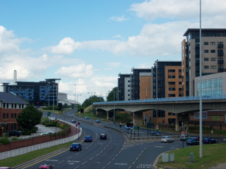
The Sheffield Parkway is a major dual carriageway which runs between the City of Sheffield and junction 33 of the M1 in South Yorkshire, England. The 5.5-mile (8.9 km) road was opened in 1974.

<span class="mw-page-title-main">Wolverhampton Ring Road</span> Road in Harlow

The A4150 Wolverhampton Inner Ring Road is a ring road that encircles the city centre of Wolverhampton in the West Midlands, England. The circumference of the road is around 2.1 miles (3.4 km). Technically, the route is listed as an "Inner Ring Road", although only a tiny section of the "Outer Ring Road" was ever constructed with only one of the two designed carriageways built. A second carriageway was built in 2017 along a short stretch between Patshull Avenue and Stafford Road. The section of outer ring road is called Wobaston Road and classified as U119.

<span class="mw-page-title-main">A594 road (Leicester)</span> Road in Leicester

The A594 Central Ring is the name of Leicester's central distributor road network.

<span class="mw-page-title-main">Transport in Sheffield</span>

Transport in Sheffield, England is developed around the city's unusual topography and medieval street plan. Once an isolated town, the transport infrastructure changed dramatically in the 19th and 20th centuries. The city now has road and rail links with the rest of the country, and road, bus and trams for local transport.

<span class="mw-page-title-main">Sheaf Square</span>

Sheaf Square is a municipal square lying immediately east of the city centre of Sheffield, England.

<span class="mw-page-title-main">Bridgehouses railway station</span> Disused railway station in South Yorkshire, England

Bridgehouses railway station was the terminal station of the Sheffield, Ashton-under-Lyne and Manchester Railway from its opening in 1845 until the opening of the Wicker Arches, a 660-yard (600 m) long viaduct across the Don Valley, which supported the new Sheffield Victoria opened on 15 September 1851. On 1 January 1847 a half-mile connecting line to the Wicker station of the Midland Railway had been constructed in order to increase goods traffic and enable wagon transfers. This short steeply graded line, enclosed within a tunnel for almost its entire length was known locally as the Fiery Jack.

Sheffield City Centre is a district of the City of Sheffield and is covered partly by the City ward of the City of Sheffield. It includes the area that is within a radius of roughly 0.75 miles (1.2 km) of Sheffield Cathedral and is encircled by the Inner Ring Road, a circular route started in the late 1960s and completed in 2007. As well as the cathedral, buildings in the city centre include the Grade I listed Town Hall, the City Hall and the Winter Gardens. Several areas of the city centre have been designated as quarters. It is home to the city's major business, transport, leisure and cultural attractions.

<span class="mw-page-title-main">A5103 road</span> Road in Manchester

The A5103 is a major road in England. It runs from Piccadilly Gardens in Manchester city centre to junction 3 of the M56 motorway and is one of Manchester's principal radial routes.

<span class="mw-page-title-main">Sheffield Outer Ring Road</span>

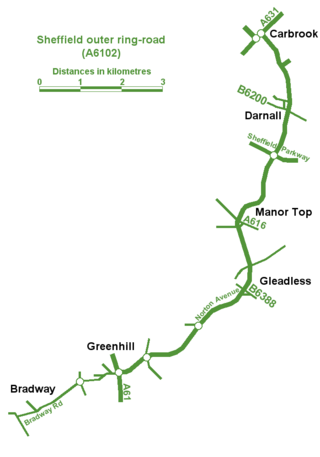
Sheffield Outer Ring Road is one of two main routes circumventing Sheffield, England, a partial ring around Sheffield City Centre and its suburbs.

<span class="mw-page-title-main">Castlegate Quarter</span>

The Castlegate Quarter is one of the eleven quarters of Sheffield city centre. It is named after Castlegate, the quarter's main thoroughfare. The boundaries of the Castlegate Quarter are formed by Castlegate and the River Don to the north, Exchange Place to the east, Commercial Street and part of the High Street to the south, and Angel Street and Snig Hill to the west. For the latter part of the 20th century, the Castlegate Quarter was dominated by Castle Market, a large indoor market building. Following the demolition of Castle Market in 2015, the quarter is now undergoing regeneration as of 2020.

<span class="mw-page-title-main">Transport in Leeds</span> Road, rail and bus transportation in Leeds, England

Transport within Leeds consists of extensive road, bus and rail networks. The city has good rail and road links to the rest of the country. Leeds railway station is one of the busiest in Britain, and Leeds is connected to the national road network via the A1(M) motorway, M1 motorway and M62 motorway. The city is served by Leeds Bradford Airport.

Sheaf Valley Quarter is an area in the centre of Sheffield, England. It is one of Sheffield's 11 designated City Centre Quarters, situated around the rail station and River Sheaf. Its borders are Commercial Street and a bowstring bridge to the north, the railway line to the east, Granville Road to the south (excluding Granville Square, Suffolk Road, Sheaf Square and Howard Street to the south west and Arundel Gate to the west. It is named after the River Sheaf, which flows from the south of the city, underneath the current station and into the River Don and Castlegate. It is one of only 2 quarters with some land outside the ring road.

<span class="mw-page-title-main">Chesterfield Central railway station</span> Former railway station in Derbyshire, England

Chesterfield Central was a railway station serving the town of Chesterfield, Derbyshire, England.

<span class="mw-page-title-main">Park Square, Sheffield</span>

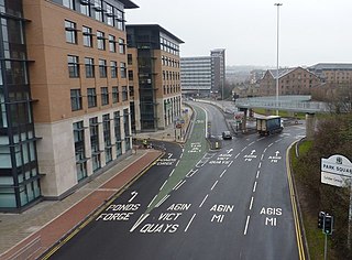
Park Square is a major roundabout in Sheffield, England. The Sheffield Parkway, a major road from M1 Junction 33, terminates here. It is located next to Ponds Forge and Victoria Quays.

<span class="mw-page-title-main">20th century road schemes in Bristol</span>

Road building was central to planning policy for much of the 20th century in Bristol, England. The planned road network evolved over time but at its core was a network of concentric ring roads and high-capacity radial roads.

References

  1. "Delight at Derek Dooley Way". The Sheffield Star. 23 July 2008. Retrieved 31 July 2008.
  2. "Connect Sheffield map". Sheffield City Council. Archived from the original on 9 October 2007.
  3. "Rodney Crowell – Glasgow Girl lyrics". Genius.com. Retrieved 7 February 2023.