Leuwiliang

Last updated
Leuwiliang
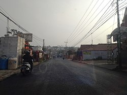
Jl Raya Leuwiliang.jpg
Main road of Leuwiliang
Indonesia Bogor Regency location map.svg
Red pog.svg
Leuwiliang
Location in Bogor Regency, Java and Indonesia
Java location map plain.svg
Red pog.svg
Leuwiliang
Leuwiliang (Java)
Indonesia location map.svg
Red pog.svg
Leuwiliang
Leuwiliang (Indonesia)
Coordinates: 6°34′27″S106°37′55″E / 6.574158°S 106.632011°E / -6.574158; 106.632011
Country Indonesia
Region Java
Province West Java
Regency Bogor Regency
Area
  Total61.51 km2 (23.75 sq mi)
Elevation
215 m (705 ft)
Population
 (mid 2023 estimate [1] )
  Total131,352
  Density2,100/km2 (5,500/sq mi)
Time zone UTC+7 (IWST)
Postcode
166xx
Area code (+62) 251
Vehicle registration F
Villages 11
Website kecamatanleuwiliang.bogorkab.go.id

Leuwiliang is a town and an administrative district (Indonesian: kecamatan) in the Bogor Regency of the province of West Java on Java in Indonesia. It is within that part of the regency that is projected to be split off to form a putative new West Bogor Regency, but still remaining part of Jakarta's metropolitan area.

Leuwiliang District covers an area of 61.51 km2, and had a population of 113,280 at the 2010 Census [2] and 124,760 at the 2020 Census; [3] the official estimate as at mid 2023 was 131,352 - comprising 67,780 males and 63,572 females. [1] The administrative centre is at the town of Leuwimekar, and the district is sub-divided into eleven villages (desa), all sharing the postcode of 16640, as listed below with their areas and populations as at mid 2023. [1]

Kode
Wilayah
Name of
desa
Area
in
km2
Population
mid 2023
estimate
32.01.14.2001Leuwiliang (town)2.9714,686
32.01.14.2002Purasari6.3214,226
32.01.14.2003Karyasari6.869,494
32.01.14.2004Pabangbon11.926,919
32.01.14.2005Karacak7.1012,920
32.01.14.2006Barengkok4.5012,870
32.01.14.2007Leuwimekar2.4413,777
32.01.14.2008Puraseda3.909,958
32.01.14.2009Cibeber I6.1611,628
32.01.14.2010Cibeber II5.1410,698
32.01.14.2011Karehkel4.2014,176
32.01.14Totals61.51131,352

Related Research Articles

Gunung Putri is a town and an administrative district in the Bogor Regency, West Java, Indonesia, and is also part of the Jabodetabek metropolitan area. The district covers an area of 56.31 km2, and had a population of 329,918 at the 2010 Census and 297,724 at the 2020 Census; the official estimate as at mid 2023 was 294,195 - comprising 148,339 males and 135,856 females. The administrative centre is located at Wanaherang, and the district is sub-divided into ten villages (desa), as listed below with their areas and their populations as at mid 2023, together with their postcodes.

Klapanunggal or Kelapanunggal is a town and an administrative district in the Bogor Regency, West Java, Indonesia. Jonggol is a town and an administrative district in the Bogor Regency, West Java, Indonesia. The town is located 50 km to the southeast of Jakarta. The district is part of the Greater Jakarta metropolitan area, and covers a land area of 103.78 km2. It had a population of 95,025 at the 2010 Census and 127,561 at the 2020 Census; the official estimate as at mid 2023 was 125,641, comprising 64,131 males and 61,510 females. The district centre is at the town of Kembang Kuning, and the district is sub-divided into nine villages (desa), all sharing the postcode of 16710, as listed below with their areas and populations as at mid 2023.

<span class="mw-page-title-main">Rumpin</span> Town and District in West Java, Indonesia

Rumpin (Sundanese:ᮛᮥᮙ᮪ᮕᮤᮔ᮪) is a town and an administrative district (kecamatan) in Bogor Regency, in the Province of West Java, Indonesia, and thus part of Jakarta's metropolitan area.. This district has a postal code of 16350.

Sukamakmur is a town and an administrative district in the Bogor Regency, West Java, Indonesia. The district is part of the Greater Jakarta metropolitan area, and covers a land area of 154 km2. It had a population of 74,578 at the 2010 Census and 85,565 at the 2020 Census; the official estimate as at mid 2023 was 92,167, comprising 47,882 males and 44,285 females. The district centre is at the town of Sukamakmur, and the district is sub-divided into ten villages (desa), all sharing the postcode of 16831, as listed below with their areas and populations as at mid 2023.

Caringin is a town and an administrative district in the Bogor Regency, West Java, Indonesia - not to be confused with the district of the same name in Sukabumi Regency - and thus part of Jakarta's larger conurbation; the district is often considered as one of Jakarta's outermost suburbs, although the closest city in the region to Caringin is Bogor city, as it lies just a few kilometres south of that city.

Cigombong is a town and an administrative district in the Bogor Regency, West Java, Indonesia and thus part of Jakarta's larger conurbation; the district is the most southern in the regency and lies a few kilometres south of Bogor city.

Cijeruk is a town and an administrative district in the Bogor Regency, West Java, Indonesia and thus part of Jakarta's larger conurbation.

Tamansari is a town and an administrative district in the Bogor Regency, West Java, Indonesia and thus part of Jakarta's larger conurbation. It is not to be confused with other districts of the same name in Boyolali Regency, West Jakarta City or Tasikmalaya City.

Kemang is a town and an administrative district in the Bogor Regency, West Java, Indonesia and thus part of Jakarta's larger conurbation. It is not to be confused with other districts of the same name in Boyolali Regency, West Jakarta City or Tasikmalaya City.

Ciseeng is a town and an administrative district in the Bogor Regency, West Java, Indonesia and thus part of Jakarta's larger conurbation.

Pamijahan is a town and an administrative district in the Bogor Regency, West Java, Indonesia and thus part of Jakarta's metropolitan area.

Cibungbulang is an administrative district in the Bogor Regency, West Java, Indonesia and thus part of Jakarta's metropolitan area.

Ciampea is a town and an administrative district in the Bogor Regency, West Java, Indonesia and thus part of Jakarta's metropolitan area.

Tenjolaya is an administrative district in the Bogor Regency of West Java Province, Indonesia and thus part of Jakarta's metropolitan area.

Tenjo is a town and an administrative district in the Bogor Regency of West Java Province, Indonesia and thus part of Jakarta's metropolitan area.

Dramaga is a town and an administrative district in the Bogor Regency of West Java Province, Indonesia and thus part of Jakarta's metropolitan area.

Parung Panjang is a town and an administrative district in the Bogor Regency of West Java Province, Indonesia and thus part of Jakarta's metropolitan area.

Cigudeg is a town and an administrative district in the Bogor Regency of West Java Province, Indonesia and thus part of Jakarta's metropolitan area.

Jasinga is a town and an administrative district in the Bogor Regency of West Java Province, Indonesia and thus part of Jakarta's metropolitan area.

Sukajaya is a town and an administrative district in the Bogor Regency of West Java Province, Indonesia and thus part of Jakarta's metropolitan area.

References

  1. 1 2 3 Badan Pusat Statistik, Jakarta, 26 September 2024, Kecamatan Leuwiliang Dalam Angka 2024 (Katalog-BPS 1102001.3201020)
  2. Biro Pusat Statistik, Jakarta, 2011.
  3. Badan Pusat Statistik, Jakarta, 2021.