The Avenue of the Saints is a 563-mile-long (906 km) highway in the Midwestern United States that connects St. Louis, Missouri, and St. Paul, Minnesota.

Interstate 694 (I-694) is an east–west auxiliary Interstate Highway located in the Minneapolis–Saint Paul metropolitan area in the US state of Minnesota. The western terminus of the route is at its junction with I-94, I-494, and US Highway 52 (US 52) in Maple Grove. The eastern terminus of I-694 is at its junction with I-94 and I-494 at the Woodbury–Oakdale city line. I-694 comprises the northern and northeastern portions of a beltway around the Twin Cities, with I-494 forming the remainder of the beltway. The speed limit is 60 mph (97 km/h). Interstate Highways outside of the loop in Minnesota may be signed as high as 70 mph (110 km/h) but can only reach 60 mph (97 km/h) inside the loop.

The W. Howard Frankland Bridge is the central fixed-link bridge spanning Old Tampa Bay from St. Petersburg, Florida to Tampa, Florida. It is one of three bridges connecting Hillsborough County and Pinellas County; the others being Gandy Bridge and Courtney Campbell Causeway. The bridge carries Interstate 275 and is by far the most traveled of the bay's bridges.

Minnesota State Highway 610 (MN 610) is an east–west freeway in the Twin Cities region of Minnesota. The freeway connects Interstate 94 (I-94), County Road 81, and CR 130 in northern Hennepin County to U.S. Highway 10 (US 10) in southern Anoka County. MN 610 crosses the Mississippi River on the Richard P. Braun Bridge between suburban Brooklyn Park and Coon Rapids. The highway is 12.3 miles (19.8 km) long.

The Wakota Bridge is a ten-lane bridge carrying Interstate 494 over the Mississippi River between South St. Paul and Newport, Minnesota, United States. It was completed in 2010, replacing a four-lane span built in 1959. The name was given to the previous span in the early 1960s, and is derived from the two counties it connects, Washington and Dakota. Lunda Construction Company won the bid to build a new five-lane west-bound span, remove the existing bridge, and build a new five-lane east-bound span, which was completed in 2010. It is the widest bridge in Minnesota in number of lanes, along with the I-35W Saint Anthony Falls Bridge in Minneapolis.

Interstate 35E (I-35E) is an Interstate Highway in the US state of Minnesota, passing through downtown Saint Paul. It is one of two through routes for I-35 through the Twin Cities of Minneapolis and Saint Paul, the other being I-35W through Minneapolis. Thus, both ends of I-35E are shared with I-35W and I-35.

Interstate 35W (I-35W) is an Interstate Highway in the US state of Minnesota, passing through downtown Minneapolis. It is one of two through routes for I-35 through the Twin Cities of Minneapolis and Saint Paul, the other being I-35E through downtown Saint Paul.
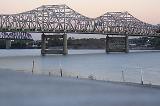
The John F. Kennedy Memorial Bridge is a six-lane, single-deck cantilever bridge that carries southbound Interstate 65 across the Ohio River, connecting Louisville, Kentucky and Jeffersonville, Indiana. The main span is 700 feet (213 m) and the bridge has a total length of 2,498 feet (761 m). The span carries six southbound lanes. It is named after U.S. President John F. Kennedy.

Minnesota State Highway 280 is a 3.710-mile-long (5.971 km) highway in the Twin Cities region of Minnesota that travels from its Interchange with Interstate 94/U.S.Route 12/US Route 52 (I-94/US 12/US 52) in Saint Paul to its interchange with I-35W in Roseville.

The Hastings High Bridge was a continuous steel through truss bridge that spanned the Mississippi River in Hastings, Minnesota, United States. It was designed by Sverdrup and Parcel and was built in 1951 by Graus Construction Company of Hasting for $356,000. It was demolished in late 2013 when the current Hastings Bridge opened. It had been scheduled to be torn down and replaced by MNDot in 2019, but after the I-35W bridge collapse in Minneapolis, it was re-prioritized and construction started in 2010.

Big Rivers Regional Trail is a paved 4.5-mile (7.2 km) rail trail that overlooks the confluence of the Minnesota and Mississippi rivers along the northern edge of Dakota County, Minnesota, United States. It runs between the cities of Eagan and Lilydale.

U.S. Highway 52 (US 52) enters the state of Minnesota at the unincorporated community of Prosper, north of the town of Burr Oak, Iowa. The route is marked north–south in Minnesota along its independent segment from the Iowa state line to downtown St. Paul. US 52 is not signed along the length of its concurrency with Interstate 94 (I-94) from downtown St. Paul to the North Dakota state line at Moorhead and Fargo.

The Pearl Harbor Memorial Bridge, commonly referred to as the Q Bridge by locals, is an extradosed bridge that carries Interstate 95 over the mouth of the Quinnipiac River in New Haven, in the U.S. state of Connecticut. This bridge replaced the original 1,300 m (0.8 mi) span which opened on January 2, 1958. The old bridge had a girder and floorbeam design where steel beams supported a concrete bridge deck that carried three lanes of traffic in each direction with no inside or outside shoulders. The bridge was officially dedicated as the Pearl Harbor Memorial Bridge in 1995 to commemorate the attack on Pearl Harbor.

U.S. Highway 169 (U.S. 169) is a major north–south highway in the U.S. state of Minnesota, connecting the Minnesota River valley with the Twin Cities and the Iron Range. Much of the route is built to expressway or freeway standards.

Interstate 35 (I-35) is a north–south Interstate Highway that stretches from Laredo, Texas, to Duluth, Minnesota. In the US state of Minnesota, I-35 enters from Iowa and heads north toward the twin cities of Minneapolis and Saint Paul. South of the metropolitan area, I-35 splits into two branches; I-35E runs through Saint Paul and I-35W through Minneapolis. These two branches rejoin north of the Twin Cities, and the highway continues north to Duluth, where it terminates at State Highway 61 (MN 61). The highway was authorized in 1956 and the first segment opened in 1958. It reached Duluth in 1971, and the final segment to east Duluth opened in 1992.
Moses Wheeler Bridge carries Interstate 95 over the Housatonic River between Stratford and the Devon section of Milford. The current bridge is a 14-span continuous girder and floorbeam structure that carries three lanes of traffic in each direction, with full inside and outside shoulders. The current bridge, completed in 2016, replaces a pre-existing structure that was completed as part of the original Connecticut Turnpike in 1958. The original bridge was a 34-span plate girder structure with a concrete deck with three 12-foot travel lanes in each direction and no shoulders. The central span of the original bridge over the river's navigation channel included a pin and hanger assembly, which are no longer used in bridge construction in the United States. Construction on the Moses Wheeler Bridge began in 1955 and opened on January 2, 1958.

The Carl E. Stotz Memorial Little League Bridge, formerly known as the Market Street Bridge, carries approximately 27,700 vehicles a day on U.S. Route 15 over the West Branch Susquehanna River between Williamsport and South Williamsport in Lycoming County, Pennsylvania, in the United States. It is the seventh bridge on the site and was built at a cost of over $60,000,000.

U.S. Highway 61 (US 61) is a U.S. Highway in southeastern and east-central Minnesota, which runs from the Mississippi River Bridge at La Crescent and continues north to its northern terminus at its junction with Interstate 35 (I-35) at the city of Wyoming.

Interstate 74 (I-74) is the central freeway through the Iowa Quad Cities. It roughly divides Davenport to the west and Bettendorf to the east. The Interstate Highway begins at an interchange with I-80 at the northeastern edge of Davenport and continues into Illinois at the Mississippi River by crossing the I-74 Bridge. The freeway was built in stages during the late 1960s and early 1970s.
The Pawtucket River Bridge is a twin span, six-lane highway bridge that carries Interstate 95 (I-95) over the Pawtucket River in Pawtucket, Rhode Island. The original bridge was built in 1958 and rehabilitated in 1996. The bridge was demolished in 2012-13 and replaced with a new deck arch bridge that was completed in summer 2013. In November 2016, the bridge was officially renamed the James E. Doyle Pawtucket River Bridge in memory of the former mayor of Pawtucket, who died two months earlier.

