Hamilton County is a county in the U.S. state of New York. As of the 2010 census, the population was 4,836, making it the least populous county in New York. With an area nearly the size of Delaware, but with a population in 2019 of only 4,416, it is the least densely populated county east of the Mississippi River. Its county seat is Lake Pleasant. The county is named after Alexander Hamilton, the only member of the New York State delegation who signed the United States Constitution in 1787 and later the first United States Secretary of the Treasury. The county was created in 1816 and organized in 1847.

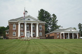
Inlet is a town in Hamilton County, New York, United States. The population was 333 at the 2010 census. The name is derived from its location at the eastern end (inlet) of Fourth Lake, part of the Fulton Chain of Lakes.

Ohio is a town in Herkimer County, New York, United States. The population was 1,002 at the 2010 census. The town is named after the state of Ohio. The town is in the northern part of the county and northeast of Utica. Part of Ohio is within the Adirondack Park.

Conesus Lake is a lake located in Livingston County, New York. Conesus Lake is the westernmost of New York's eleven Finger Lakes. It is located off Interstate 390 about 15 miles (24 km) south of Interstate 90.

Allan H. Treman State Marine Park is a 91-acre (0.37 km2) state park and marina located in the City of Ithaca in Tompkins County, New York, United States. The park is located at the south end of Cayuga Lake, one of the 11 Finger Lakes of New York. The park's namesake, Allan Hosie Treman (1899-1975) was a Cornell University law professor, Ithaca city counsel, and member of the Finger Lakes Park Commission. He is the son of Robert H. Treman, who also has a state park named in his honor.
New York State Route 13 (NY 13) is a state highway that runs mainly north–south for 152.30 miles (245.10 km) between NY 14 in Horseheads and NY 3 west of Pulaski in Central New York in the United States. In between, NY 13 intersects with Interstate 81 (I-81) in Cortland and Pulaski and meets the New York State Thruway (I-90) in Canastota. NY 13 is co-signed with several routes along its routing, most notably NY 34 and NY 96 between Newfield and Ithaca; NY 80 between DeRuyter and Cazenovia; and NY 5 between Chittenango and Canastota.

Rensselaer Lake is an artificial lake in Albany, New York, United States named for Major-General Stephen Van Rensselaer, last patroon of Rensselaerswyck. The lake was Albany's first municipally-owned source of water. It is part of a 57-acre (23 ha) park and the state's Albany Pine Bush Preserve. The lake and park have been under the purview of the Albany Water Authority since 2003.
New York State Route 38 (NY 38) is a north–south state highway in the Finger Lakes region of New York in the United States. Its southern terminus is at an intersection with NY 96 in the town of Owego in Tioga County. The northern terminus is at a junction with NY 104A in the town of Sterling in Cayuga County. NY 38 is a two-lane local road for most of its length. The route is the main access road to parts of Auburn, Dryden, Newark Valley and Port Byron. It passes through mountainous terrain in Tioga and Cortland counties, but the terrain levels out as it heads through the Finger Lakes area and Cayuga County.
New York State Route 256 (NY 256) is a north–south state highway located within Livingston County, New York, in the United States. It extends for 21.08 miles (33.92 km) across mostly rural terrain from an intersection with NY 63 in the village of Dansville to a junction with NY 15 on the Geneseo–Livonia town line. The northern half of NY 256, named West Lake Road, passes along the western shore of Conesus Lake. NY 256 was assigned as part of the 1930 renumbering of state highways in New York to an alignment extending from Groveland to modern U.S. Route 20A (US 20A) west of Lakeville. It was extended north to its current northern terminus c. 1940 and south to Dansville in stages during the 1930s and 1940s.
New York State Route 89 (NY 89) is a north–south state highway in central New York in the United States. It extends for 62.35 miles (100.34 km) from an intersection with NY 13, NY 34, and NY 96 in the Tompkins County city of Ithaca to an interchange with NY 104 in the Wayne County town of Wolcott. The route spans a total of three counties, connecting the heart of the Finger Lakes Region to a point 6 miles (10 km) south of Lake Ontario. Along the way, NY 89 intersects two regionally important highways: the conjoined routes of U.S. Route 20 (US 20) and NY 5 in Seneca Falls and NY 31 in Savannah. NY 89 runs along the western edge of Cayuga Lake from Ithaca to Seneca Falls.
New York State Route 9N (NY 9N) is a north–south state highway in northeastern New York in the United States. It extends from an intersection with U.S. Route 9 (US 9), NY 29, and NY 50 in the city of Saratoga Springs to a junction with US 9 and NY 22 in the Clinton County hamlet of Keeseville. At 143.49 miles (230.92 km) in total length, NY 9N is the longest letter-suffixed route in the state. It is concurrent with its parent route for 1 mile (1.6 km) in the village of Lake George and for three blocks in the hamlet of Elizabethtown.
New York State Route 54A (NY 54A) is a state highway in the western part of New York in the United States. It runs in a northeast to southwest direction through part of the Finger Lakes district of New York. The southern terminus of NY 54A is at NY 54 south of Hammondsport. The northern terminus is in Penn Yan, where it rejoins NY 54. Unlike NY 54, which runs along the east side of Keuka Lake, NY 54A has a more circuitous route around the western side of the lake.
New York State Route 28N (NY 28N) is an east–west state highway in the North Country of New York in the United States. It extends for 50.95 miles (82.00 km) through the Adirondack Mountains from Blue Mountain Lake to North Creek. The route is a northerly alternate route to NY 28 between both locations; as such, it passes through several communities that NY 28 bypasses to the south. The westernmost 10 miles (16 km) of NY 28N overlap with NY 30 through the town of Long Lake. NY 28N and NY 30 split in the hamlet of Long Lake, from where NY 30 heads to the north and NY 28N proceeds eastward through mountainous regions of Adirondack Park.

The Moose River Plains Wild Forest is a 64,322-acre tract in the Adirondack Park in Hamilton and Herkimer counties in the state of New York in the United States of America; it is designated as Wild Forest by the New York State Department of Environmental Conservation.
Stillwater Reservoir is a man-made lake located by Beaver River, New York within the Western Adirondacks. The lake has a large amount of recreational uses including camping, canoeing, boating, fishing, hunting, snowmobiling, and cross-country skiing. The lake has undeveloped edges with remote camping on both the islands and the shoreline. Camping permits and lake information may be obtained from the hamlet of Stillwater at the Forest Ranger Headquarters. Fish species present in the reservoir are smallmouth bass, splake, rock bass, yellow perch, sunfish and brown trout. There is a state owned hard surface ramp on Stillwater Road, 28 miles east of Lowville, New York. the record low temperature for the state of New York of −52 °F (−47 °C) took place at Stillwater Reservoir, and was later tied by Old Forge on February 17, 1979.
Kayuta Lake is located northwest of Bardwell Mill, New York. Kayuta Lake Campground is located by the Black River inlet. Fish species present in the lake are smallmouth bass, pickerel, white sucker, rock bass, yellow perch, bluegill, and black bullhead. There is a carry down access on the north shore located on State Dam Road.
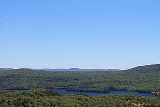
Seventh Lake is a lake located by Inlet, New York. It is part of the Fulton Chain Lakes. The outlet flows through a channel into Sixth Lake and the main inlet flows through a creek from Eighth Lake. Fish species present in the lake are brown trout, lake whitefish, lake trout, smelt, landlocked salmon, rainbow trout, white sucker, black bullhead, yellow perch, and pumpkinseed sunfish. There is a state owned hard surface ramp of NY-28, 3 miles east of Inlet with parking for 20 trucks and trailers.
Cedar Lake is located northwest of Sled Harbor, New York. Fish species present in the lake are brook trout, black bullhead, and white sucker. There is trail access on the north and west shores from Sled Harbor. There is also trail access to Whitney Lake. No motors are allowed on this lake.

Cayuga Inlet is a river located in Tompkins County, New York. It flows into the south end of Cayuga Lake by Ithaca, New York.


