Related Research Articles

Republic is a city in Ferry County, Washington, United States. The population was 992 at the 2020 census. It is the county seat of Ferry County. It was the largest mining camp in the Republic Mining District, and home to the "Hot Air Line" railway.
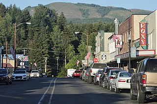
Morton is a city in Lewis County, Washington, United States. The population was 1,036 at the 2020 census.

Buckley is a city in Pierce County, Washington, United States, founded in 1882. The population was 5,114 at the 2020 census. Buckley sits below Mount Rainier and is well known for hosting the annual Log Show.

The Cowlitz River is a river in the state of Washington in the United States, a tributary of the Columbia River. Its tributaries drain a large region including the slopes of Mount Rainier, Mount Adams, and Mount St. Helens.

State Route 167 (SR 167) is a state highway in the Seattle metropolitan area of Washington state. It is commonly known as the Valley Freeway and serves the Green River Valley from Tacoma to Renton, primarily as a four-lane freeway. The 28-mile (45 km) highway begins in Tacoma at an interchange with Interstate 5 (I-5) and travels southeast to Puyallup as an undivided road. It then turns northeast onto a freeway and passes through interchanges with SR 512 in Puyallup and SR 410 in Sumner, continuing north through Auburn and Kent. After an interchange with I-405 in Renton, it terminates at an intersection with SR 900.

State Route 7 (SR 7) is a state highway in Lewis and Pierce counties, located in the U.S. state of Washington. The 58.60-mile (94.31 km) long roadway begins at U.S. Route 12 (US 12) in Morton and continues north to intersect several other state highways to Tacoma, where it ends at an interchange with Interstate 5 (I-5) and I-705. The road has several names, such as Second Street in Morton, the Mountain Highway in rural areas, Pacific Avenue in Spanaway, Parkland and Tacoma and 38th Street in Tacoma. Near the end of the highway there is a short freeway that has been proposed to be extended south parallel to an already existing railroad, owned by Tacoma Rail, which serves as the median of the short freeway.

Lester is a ghost town near Stampede Pass, just south of Snoqualmie Pass in King County, founded in 1892 by the Northern Pacific Railway. Lester is located along what is currently National Forest Development Road 54, on land owned by Tacoma Water, a division of Tacoma Public Utilities.

Heisson is an unincorporated community in Clark County, Washington.

Kentucky Route 11 (KY 11) is an American highway maintained by the Kentucky Transportation Cabinet that runs from Maysville to Barbourville. The route from Maysville to Mount Sterling is being upgraded on a new alignment as part of a "macro-corridor" within the state of Kentucky.

State Route 508 (SR 508) is a 32.84-mile (52.85 km) long state highway located in Lewis County within the U.S. state of Washington, extending from an interchange with Interstate 5 (I-5) concurrent with U.S. Route 12 (US 12) in Napavine to SR 7 in Morton. By 1916, a road between Napavine and Cinebar was constructed on the current route of SR 508 and was signed in 1937 as Secondary State Highway 5K (SSH 5K) after being extended to Morton. SSH 5K became SR 508 in 1968 and since then, a segment in Bear Canyon has been reconstructed twice between 2007 and 2009 and a bridge over the Tilton River was reconstructed in 2009.
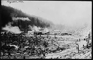
Nagrom is a ghost town in King County, Washington, United States.
The Simpson Investment Company is a privately held holding company based in Seattle, Washington in the US Pacific Northwest that specializes in manufacture of forest products. Founded as a logging company in 1890 by Sol Simpson, the company is now owned by the Reed family.
Helena is a ghost town in unincorporated Trinity County, California, United States. It is located on the North Fork of the Trinity River, 10 miles (16 km) west-northwest of Weaverville. State Route 299 runs right past the former town to the south; East Fork Road connects the highway to Helena.
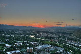
The history of Missoula, Montana begins as early as 12,000 years ago with the end of the region's glacial lake period with western exploration dating back to the Lewis and Clark Expedition of 1804–1806. The first permanent settlement was founded in 1860.
Grandfather Falls is the highest waterfall on the Wisconsin River. The total drop is 89 feet, spread out in a series of cascades over about one mile. The upper third of the falls and most of the flow, except in the spring, is diverted through a canal and a series of penstocks to feed hydroelectric generators. Grandfather Falls dam and power generating facility is owned and operated by Wisconsin Public Service Corporation.

The Satsop Hills are foothills of the Olympic Mountains in Mason County, Washington north of Matlock, Washington, between Wynoochee Lake to the west and Lake Cushman to the east.

Barneston is an extinct town in King County, in the U.S. state of Washington. The GNIS classifies it as a populated place.
High Point is an unincorporated community in King County, in the U.S. state of Washington.

Union District, formerly Union Magisterial District, is one of five historic magisterial districts in Jackson County, West Virginia, United States. The district was originally known as Hushan's Mills Township, one of five civil townships established in 1863, at the height of the Civil War; it was subsequently given the patriotic name of Union Township. In 1872, West Virginia's townships were converted into magisterial districts. When Jackson County was redistricted in the 1990s, the area of Union District was included in the new Western Magisterial District. However, the county's historic magisterial districts continue to exist in the form of tax districts, serving all of their former administrative functions except for the election of county officials.

Ripley District, formerly Ripley Magisterial District, is one of five historic magisterial districts in Jackson County, West Virginia, United States. The district was originally known as Mill Creek Township, one of five civil townships established in Jackson County after West Virginia became a state in 1863; it was renamed "Ripley Township" after its chief town in 1871, and the following year, all of West Virginia's townships were converted into magisterial districts. When Jackson County was redistricted in the 1990s, the area of Ripley District was divided between the new Eastern and Western Magisterial Districts. However, the county's historic magisterial districts continue to exist in the form of tax districts, serving all of their former administrative functions except for the election of county officials.
References
- ↑ U.S. Geological Survey Geographic Names Information System: Lindberg (historical)
- 1 2 3 "United States Enumeration District Maps for the Twelfth through the Sixteenth US Censuses, 1900-1940" (images). FamilySearch. pp. Roll 69, Washington, King-Yakima 1900-1940 > images 678, 697, 705, 709 of 969, citing NARA microfilm publication A3378 (Washington, D.C.: National Archives and Records Administration, 2003).
- 1 2 3 "Brick Houses In Lindberg". The Daily Chronicle. June 6, 1953. p. 2D. Retrieved August 12, 2024.
- ↑ Moeller, Bill (January 25, 2018). "Historic Answers to Questions You've Never Actually Asked". The Chronicle. Retrieved December 9, 2024.
- ↑ "Post Offices". Jim Forte Postal History. Retrieved August 14, 2016.
- ↑ "Railroad Commission Map of Washington, 1910, General Map Collection, 1851-2005". Washington State Archives, Digital Archives. Retrieved March 19, 2020.
- ↑ Meany, Edmond S. (1923). Origin of Washington geographic names. Seattle: University of Washington Press. p. 147.
- ↑ "Washington Place Names: Lindberg". Tacoma Public Library. Retrieved March 19, 2020.
- ↑ "Railroad map of Washington, 1928, General Map Collection, 1851-2005". Washington State Archives, Digital Archives. Retrieved March 19, 2020.
Municipalities and communities of Lewis County, Washington, United States | ||
|---|---|---|
| Cities |  | |
| Town | ||
| CDPs | ||
| Unincorporated communities | ||
| Former communities | ||
| Ghost towns | ||
| Flooded towns | ||
| Indian reservation | ||
| Footnotes | ‡This populated place also has portions in an adjacent county or counties | |
| | This Lewis County, Washington state location article is a stub. You can help Wikipedia by expanding it. |
| | This ghost town–related article is a stub. You can help Wikipedia by expanding it. |