Building deliberately built across a geopolitical boundary
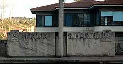
The Haskell Free Library and Opera House is the best-known among buildings that straddle the Canada–United States border. The border is marked with boulders. In this picture, Canada is on the left side and the United States is on the right.The international boundary is marked as a black line on the floor of the reading room of the Haskell Library. In this picture, Canada is on the right side of the line and the United States is on the left.Hotel Arbez in La Cure. The border runs lengthwise through the two buildings, passing just to the left of the mural. The mural and everything to the right of it lies in Switzerland, and France lies to the left.The Paul VI Audience Hall on the border between the Vatican City and Italy. The border runs crosswise through the building, with the Vatican City on the right side and Italy on the left side of the building.Line house on the border between Italy and San Marino in Dogana.House on the border of Belgium and the Netherlands in the towns of Baarle-Hertog and Baarle-Nassau respectively. Belgium is on the left marked with letter "B" on the pavement and the Netherlands is on the right marked with letter "NL" on the pavement.
In Sungai Haji Kuning at Sebatik Island, which is divided between Malaysia and Indonesia, there is a house divided by the countries' borders.[6]
Paul VI Audience Hall, located partially in the Vatican City, but mostly in Rome, Italy: the Italian part of the building is treated as an extraterritorial area of the Holy See and is used by the Pope as an alternative to Saint Peter's Square when conducting his Wednesday morning General Audience.
↑ Farfan, Matthew (2009). The Vermont–Quebec Border: Life on the Line. Arcadia Publishing. ISBN0738565148
↑ Joint Report upon the Survey and Demarcation of the Boundary between the United States and Canada from the Source of the St. Croix River to the St. Lawrence River, International Boundary Commission, 1924, pp.36,40,60,65,73–4,83,107,116,341
↑ "Chapter 1: Northern Maine and New Hampshire". United Divide: A Linear Portrait of the USA/Canada Border. The Center for Land Use Interpretation. Winter 2015. Archived from the original on 2023-05-08. Retrieved 2017-11-14.
This page is based on this Wikipedia article Text is available under the CC BY-SA 4.0 license; additional terms may apply. Images, videos and audio are available under their respective licenses.