
Whitechapel is an area in London, England, and is located in the London Borough of Tower Hamlets. It is in east London and part of the East End. It is the location of Tower Hamlets Town Hall and therefore the borough town centre. Whitechapel is located 3.4 miles (5.5 km) east of Charing Cross.

The fortifications of Portsmouth are extensive due to its strategic position on the English Channel and role as home to the Royal Navy. For this reason, Portsmouth was, by the 19th century, one of the most fortified cities in the world. The fortifications have evolved over the centuries in response to changes in tactics and technology and the area defended has increased. While the first defences focused on Portsmouth harbour, in step with the fortifications of Gosport, later defensive structures protected the whole of Portsea Island and an increasing distance inland. At the same time, the fortifications of Portsmouth and Gosport became part of the wider fortifications of the Solent. Old Portsmouth, on the southwest corner of Portsea Island, has been walled for much of its history.

Redan is a feature of fortifications. It is a work in a V-shaped salient angle towards an expected attack. It can be made from earthworks or other material.

The National Redoubt was a strategic defensive belt of fortifications built in Belgium. The National redoubt was the infrastructural cornerstone of Belgian defensive strategy from 1890–1940.

The Battle of Alton, of the First English Civil War, took place on 13 December 1643 in the town of Alton, Hampshire, England. There, Parliamentary forces serving under Sir William Waller led a successful surprise attack on a winter garrison of Royalist infantry and cavalry serving under the Earl of Crawford. The Battle of Alton was the first decisive defeat of Sir Ralph Hopton, leader of Royalist forces in the south, and the event had a significant psychological effect on him as commander. More important to Hopton was the loss of men, however, as he was already short-handed in much-needed infantry. The successful Parliamentarians were able, after their victory, to attack and successfully besiege Arundel, a larger and more formidable Royalist outpost to the south-east of Alton.

The Western Heights of Dover is a series of forts and ditches in Dover, England. They were created in the 18th and 19th centuries to augment the existing defences and protect the key port of Dover from both seaward and landward attack; by the start of the 20th century Dover Western Heights was collectively reputed to be the 'strongest and most elaborate' fortification in the country. The Army finally withdrew from the Heights in 1956–61; they are now a local nature reserve.

The fortifications of London are extensive and mostly well maintained, though many of the City of London's fortifications and defences were dismantled in the 17th and 18th century. Many of those that remain are tourist attractions, most notably the Tower of London.
The city of Winchester, Virginia, and the surrounding area, were the site of numerous battles during the American Civil War, as contending armies strove to control the lower Shenandoah Valley. Winchester changed hands more often than any other Confederate city.

Louisville's fortifications for the American Civil War were designed to protect Louisville, Kentucky, as it was an important supply station for the Union's fight in the western theater of the war. They were typically named for fallen Union officers; usually those that served in the Army of the Ohio. The inspiration for building the forts came in October 1862, when Confederate forces engaged in their largest attack in Kentucky, only to be halted at the Battle of Perryville. Construction began in 1863, going at a slow pace until Confederate forces marched on Nashville, Tennessee, in the autumn of 1864. This caused General Hugh Ewing to demand from the city to force both military convicts and local "loafers" to help build the fortifications. Due to military engineers being needed on the front lines, the fortifications in Louisville were designed by civilian assistant engineers, as were the ones in Cincinnati, Ohio. Louisville was never endangered, so the guns never fired, save for salutes.

Several of the islands strung across the South entrance of Castle Harbour, Bermuda were fortified in the early days of the territory, hence the harbour's name. When official settlement of the archipelago by England began in 1612 the first permanent town, St. George's was placed on the North side of St. George's Harbour. St. George's Harbour could be accessed directly by channels from the East. Those channels, however, were shallow, suitable, originally, only for small ships. As a consequence, and despite any major settlement on its shores, Castle Harbour was an important anchorage in the early years of the colony, with its main entrance, Castle Roads being an important route in from the open Atlantic for shipping. It was also a weak point, as it was remote from the defences of St. George's Harbour, and difficult to reach. It was quickly fortified and garrisoned by a standing militia.
The First English Civil War started in 1642. By the end of the year neither side had succeeded in gaining an advantage, although the King's advance on London was the closest Royalist forces came to threatening the city.
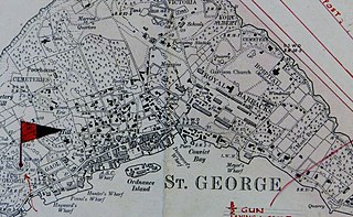
The Western Redoubt, or Fort William, is a square fort built on a crest on the eastern side of Government Hill, and within the boundaries of the original main British Army camp in the Imperial fortress colony of Bermuda, St. George's Garrison.

The fortifications of Malta consist of a number of walled cities, citadels, forts, towers, batteries, redoubts, entrenchments and pillboxes. The fortifications were built over hundreds of years, from around 1450 BC to the mid-20th century, and they are a result of the Maltese islands' strategic position and natural harbours, which have made them very desirable for various powers.

The fortifications of Plymouth in Devon are extensive due to its natural harbour, its commanding position on the Western Approaches and its role as the United Kingdom's largest naval base. The first medieval defences were built to defend Sutton Harbour on the eastern side of Plymouth Sound at the mouth of the River Plym, but by the 18th century, naval activity had begun to shift westward to Devonport at the mouth of the River Tamar. During the Victorian era, advances in military technology led to a huge programme of fortification encompassing the whole of Plymouth Sound together with the overland approaches. Many of these works remained in military use well into the 20th century.

The siege of Plymouth took place during the First English Civil War, when Royalist forces besieged Plymouth, in Devon, held by a Parliamentary garrison.

Apilan and kotamara are two Malay nautical terms which refers to the structure on a vessel where the cannon is installed. This term is used especially on Malay ships and boats.

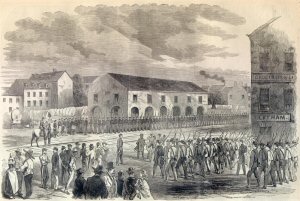
Whitechapel Mount was a large artificial mound of disputed origin. A prominent landmark in 18th century London, it stood in the Whitechapel Road beside the newly constructed London Hospital, being not only older, but significantly taller. It was crossed by tracks, served as a scenic viewing-point, could be ascended by horses and carts, and supported some trees and formal dwelling-houses. It has been interpreted as: a defensive fortification in the English Civil War; a burial place for victims of the Great Plague; rubble from the Great Fire of London; and as a laystall. Possibly all of these theories are true to some extent.

Lord Salisbury described Malta, Gibraltar, Bermuda, and Halifax as Imperial fortresses at the 1887 Colonial Conference, though by that point they had been so designated for decades. Later historians have also given the title "imperial fortress" to St. Helena and Mauritius.
Fort George is a square fort built on the crest of Mount Hill to the west of St. George's Town, near to, but outside of the boundaries of the original main British Army camp in the Imperial fortress colony of Bermuda, St. George's Garrison.

