List of Beam approach beacon system units

Last updated

This is a List of Beam Approach beacon system Units of the Royal Air Force.

Contents

The first system to guide RAF aircraft safely down onto a runway was called the Standard Blind Approach (SBA) system and was trialled in the late 1930s. It was also being used by a few civil airports. By late 1941 the word 'Blind' was changed to 'Beam' as it was felt that blind did not give a reassuring feel to a system used when visibility was very low. The word Standard came from Standard Radio, the name of the company that made the equipment under license from the German company that designed it. However the equipment was also 'standard' fit on RAF aircraft. The change from Blind to Beam is evidenced in the two sets of Unit names in the tables below.

There were no physical beams in the system at all, rather it relied on a heavily distorted dipole radiation pattern using a single transmitter. Instead of 'beams' it used a single heavily distorted toroid that was flipped left and right with a periodicity that simulated a morse code letter, the plane of equal field strength in this arrangement being mathematically equal to a line of zero width - a perfect 'beam' from an imperfect, cheaper, and simple radio transmitter. SBA was not automatic, the pilot flew the aircraft at all times.

The Beam Approach Beacon System (BABS) is an automatic radar landing system developed in the early 1940s but not used until much later when it replaced the SBA system.

Blind Approach Training flights

Name [1] [2] FormedLocationAircraftDisbanded atDisbandedUnit became
1 Blind Approach Training Flight12 January 1941 Abingdon Armstrong Whitworth Whitley Abingdon8 November 19411501 (Beam Approach Training) Flight
2 Blind Approach Training FlightFebruary 1941 Linton-on-Ouse Armstrong Whitworth Whitley Driffield 8 November 19411502 (Beam Approach Training) Flight
3 Blind Approach Training Flight27 January 1941 Mildenhall Vickers Wellington Mildenhall8 November 19411503 (Beam Approach Training) Flight
4 Blind Approach Training Flight17 December 1940 Wyton Vickers WellingtonWyton8 November 19411504 (Beam Approach Training) Flight
5 Blind Approach Training Flight1 January 1941 Honington Vickers Wellington
Airspeed Oxford
Honington8 November 19411505 (Beam Approach Training) Flight
6 Blind Approach Training Flight6 January 1941 Waddington Bristol Blenheim
Handley Page Hampden
Airspeed Oxford
Douglas Boston
Waddington8 November 19411506 (Beam Approach Training) Flight
7 Blind Approach Training Flight18 January 1941 Finningley Bristol Blenheim
Handley Page Hampden
Airspeed Oxford
Finningley8 November 19411507 (Beam Approach Training) Flight
8 Blind Approach Training FlightJanuary 1941 Wattisham Bristol Blenheim Horsham St Faith 8 November 19411508 (Beam Approach Training) Flight
9 Blind Approach Training FlightJanuary 1941 Thornaby Vickers Wellington
Airspeed Oxford
Dyce 8 November 19411509 (Beam Approach Training) Flight
10 Blind Approach Training FlightJanuary 1941 Leuchars Vickers Wellington
Airspeed Oxford
Leuchars8 November 19411510 (Beam Approach Training) Flight
11 Blind Approach Training Flight22 September 1941 Upwood Airspeed OxfordUpwoodOctober 19411511 (Beam Approach Training) Flight
12 Blind Approach Training Flight22 September 1941 Dishforth Airspeed OxfordDishforthOctober 19411512 (Beam Approach Training) Flight
13 Blind Approach Training Flight22 September 1941HoningtonHoningtonOctober 19411513 (Beam Approach Training) Flight
14 Blind Approach Training Flight22 September 1941 Coningsby ConingsbyOctober 19411514 (Beam Approach Training) Flight
15 Blind Approach Training Flight22 September 1941 Swanton Morley Airspeed OxfordSwanton MorleyOctober 19411515 (Beam Approach Training) Flight
16 Blind Approach Training Flight22 September 1941 Topcliffe Llanbedr October 19411516 (Beam Approach Training) Flight
17 Blind Approach Training FlightOctober 1941WattishamAirspeed Oxford
de Havilland Tiger Moth
Ipswich October 19411517 (Beam Approach Training) Flight
20 Blind Approach Training Flight10 October 1941 Breighton Airspeed Oxford
de Havilland Tiger Moth
RAF Holme October 19411520 (Beam Approach Training) Flight
21 Blind Approach Training FlightOctober 1941 Stradishall Airspeed OxfordStradishallOctober 19411521 (Beam Approach Training) Flight
22 Blind Approach Training FlightOctober 1941 Docking Airspeed OxfordDockingOctober 19411522 (Beam Approach Training) Flight
23 Blind Approach Training FlightOctober 1941 Little Rissington Little RissingtonOctober 19411523 (Beam Approach Training) Flight
24 Blind Approach Training FlightOctober 1941 Bottesford Airspeed OxfordBottesfordOctober 19411524 (Beam Approach Training) Flight
25 Blind Approach Training FlightOctober 1941 Brize Norton Brize NortonOctober 19411525 (Beam Approach Training) Flight
26 Blind Approach Training Flight3 October 1941 Andover Airspeed Oxford Thruxton October 19411526 (Beam Approach Training) Flight

Beam Approach Training flights

Name [3] [4] [5] FormedLocationAircraftDisbanded atDisbandedUnit became
1501 (Beam Approach Training) Flight8 November 1941AbingdonStanton Harcourt15 November 1943Disbanded
1502 (Beam Approach Training) Flight8 November 1941DriffieldLeconfield15 August 1943Disbanded
1503 (Beam Approach Training) Flight8 November 1941MildenhallLindholme6 August 1943Disbanded
1504 (Beam Approach Training) Flight8 November 1941WytonNewmarket21 August 1943Disbanded
1505 (Beam Approach Training) Flight8 November 1941HoningtonUpper Heyford3 February 1943Disbanded
1506 (Beam Approach Training) Flight8 November 1941WaddingtonSkellingthorpe21 October 1943Disbanded
1507 (Beam Approach Training) Flight8 November 1941FinnigleyGransden Lodge27 November 1943Disbanded
1508 (Beam Approach Training) Flight8 November 1941Swanton MorleyUnk1 March 1944Became 1508 (Radio Aids Training) Flight
1509 (Beam Approach Training) Flight8 November 1941ThornabyDyce14 August 1944Absorbed
1510 (Beam Approach Training) Flight8 November 1941LeucharsUnkMarch 1943Became 1510 (BABS) Flight
1511 (Beam Approach Training) FlightOctober 1941UpwoodUnk15 September 1945Became 1511 (Radio Aids Training) Flight
1512 (Beam Approach Training) FlightOctober 1941DishforthBanff30 August 1944Disbanded
1513 (Beam Approach Training) FlightOctober 1941HoningtonAirspeed Oxford
Avro Anson
Bramcote1 December 1946Became 1513 (Radio Aids Training) Flight
1514 (Beam Approach Training) FlightOctober 1941ConingsbyFiskerton9 January 1945Disbanded
1515 (Beam Approach Training) FlightOctober 1941Swanton MorleyAirspeed OxfordColby Grange1 June 1945Disbanded
1516 (Beam Approach Training) FlightOctober 1941LlanbedrUnk15 September 1945Became 1516 (Radio Aids Training) Flight
1517 (Beam Approach Training) FlightOctober 1941WattishamWheaton Aston17 December 1945Disbanded
1518 (Beam Approach Training) Flight3 November 1941ScamptonEdzell30 August 1944Disbanded
1519 (Beam Approach Training) FlightNovember 1941South CerneyFeltwell3 July 1945Disbanded
1520 (Beam Approach Training) FlightOctober 1941Holme-on-Spalding-MoorSturgate29 May 1945Disbanded
1521 (Beam Approach Training) FlightOctober 1941StradishallUnk15 September 1945Became 1521 (Radio Aids Training) Flight
1522 (Beam Approach Training) FlightOctober 1941DockingWatchfieldApril 1942Absorbed
1523 (Beam Approach Training) FlightOctober 1941Little RissingtonLittle Rissington17 December 1945Disbanded
1524 (Beam Approach Training) FlightOctober 1941BottesfordTollerton9 January 1945Disbanded
1525 (Beam Approach Training) FlightOctober 1941Brize NortonDocking26 June 1945Disbanded
1526 (Beam Approach Training) FlightOctober 1941ThruxtonHampstead Norris9 November 1944Disbanded
1527 (Beam Approach Training) Flight29 October 1941PrestwickUnk15 September 1945Became 1527 (Radio Aids Training) Flight
1528 (Beam Approach Training) Flight22 November 1941West MallingUnk15 September 1945Became 1528 (Radio Aids Training) Flight
1529 (Beam Approach Training) Flight22 November 1941WitteringFairford16 February 1946Disbanded
1530 (Beam Approach Training) Flight14 August 1942HunsdonWittering1 August 1944Disbanded
1531 (Beam Approach Training) Flight20 July 1942CranageCranage29 May 1945Disbanded
1532 (Beam Approach Training) Flight15 October 1942HullavingtonBabdown Farm15 June 1942Disbanded
1533 (Beam Approach Training) Flight27 October 1942Church LawfordChurch Lawford3 April 1945Disbanded
1534 (Beam Approach Training) Flight7 December 1942ShawburyShawbury29 May 1945Disbanded
1535 (RCAF Beam Approach Training) Flight15 December 1942Middleton St GeorgeTopcliffe30 August 1943Disbanded
1536 (Beam Approach Training) FlightMarch 1943 Grantham Airspeed OxfordSpitalgate8 May 1945Disbanded
1537 (Beam Approach Training) Flight4 May 1943UpavonLittle Rissington4 April 1947Disbanded
1538 (Beam Approach Training) Flight15 April 1943CroughtonCroughton18 October 1944Disbanded
1539 (Beam Approach Training) Flight15 April 1943South CerneySouth Cerney1 June 1945Disbanded
1540 (Beam Approach Training) Flight15 April 1943Lulsgate BottomWeston Zoyland17 December 1945Disbanded
1541 (Beam Approach Training) Flight17 May 1943StracathroStracathro11 July 1945Disbanded
1542 (Beam Approach Training) FlightJuly 1943DallachyDallachy30 August 1944Disbanded
1544 (Beam Approach Training) Flight24 January 1944ErrolErrol30 August 1944Disbanded
1545 (Beam Approach Training) FlightMarch 1945Wheaton AstonHalfpenny Green17 December 1945Disbanded
1546 (Beam Approach Training) Flight8 May 1944FaldingworthFaldingworth9 January 1945Disbanded
1547 (Beam Approach Training) Flight1 June 1945WatchfieldWatchfield1 January 1947Disbanded
1551 (Beam Approach Calibration) Flight20 November 1942BicesterBicester15 April 1943Merged

Radio Aids Training flights

Name [3] [4] [5] FormedLocationAircraftDisbanded atDisbandedUnit became
1508 (Radio Aids Training) Flight20 September 1945UnkUnk20 November 19451508 (Acclimatisation) Flight
1510 (Radio Aids Training) Flight9 August 1947UnkBircham Newton15 September 1948Absorbed
1511 (Radio Aids Training) Flight15 September 1945UnkWheaton Aston1 August 1946Disbanded
1513 (Radio Aids Training) Flight15 September 1945UnkBramcote1 December 1946Disbanded
1516 (Radio Aids Training) Flight15 September 1945UnkSnaith11 April 1946Disbanded
1521 (Radio Aids Training) Flight15 September 1945UnkLongtown1 April 1946Disbanded
1527 (Radio Aids Training) Flight15 September 1945UnkPrestwick28 February 1946Disbanded
1528 (Radio Aids Training) Flight15 September 1945UnkFairford4 March 19461555 (Radio Aids Training) Flight
1552 (Radio Aids Training) Flight15 September 1945MelbourneFull Sutton26 October 1946Disbanded
1553 (Radio Aids Training) Flight15 September 1945MelbourneMelbourne1 October 1945Disbanded
1554 (Radio Aids Training) Flight15 September 1945MelbourneMelbourne1 October 1945Disbanded
1555 (Radio Aids Training) Flight15 September 1945FairfordBircham Newton31 August 1947Disbanded
1556 (Radio Aids Training) Flight15 September 1945StradishallFairford1 April 1946Disbanded
1559 (Radio Aids Training) Flight1 October 1946OakingtonBircham Newton9 August 1947Disbanded

Other units

NameFormedLocationAircraftDisbanded atDisbandedUnit became
No. 1508 (GEE Training) Flight RAF1 March 1944UnkUnkOuston8 August 1944'C' Flight of No. 62 OTU [3]
No. 1510 (BABS) Flight RAFMarch 1943Anson9 August 19471510 (Radio Aids Training) Flight [3]
Blind Approach Training and Development Unit RAF 22 September 1939Boscombe DownAnson, WhitleyBoscombe Down14 October 1940 Wireless Intelligence Development Unit [1]
Beam Approach Calibration Flight RAFOctober 1941Oxford, AnsonBicester20 November 19421551 (Beam Approach Calibration) Flight [1]
Beam Approach Training Flight, Church Lawford RAFMarch 1942Church LawfordChurch Lawford27 October 19421533 (Beam Approach Training) Flight [6]
Beam Approach Training Flight, Nanyuki RAFNanyukiNanyuki26 June 1942Absorbed by No. 70 OTU [6]
Blind Approach Calibration Flight RAF12 July 1941WatchfieldOxford, AnsonOctober 1941Beam Approach Calibration Flight [1]
Beam Approach Development Unit RAF 4 October 1942WatchfieldAnson, Oxford, MasterHinton-in-the-Hedges15 April 1943'A' Flight, Signals Development Unit RAF [6]
Blind Landing Experimental Unit 1 October 1945WoodbridgeAnsonMartlesham Heath1 November 1949 [2]

See also

Related Research Articles

<span class="mw-page-title-main">Emergency position-indicating radiobeacon</span> Distress radio beacon, a tracking transmitter that is triggered during an accident

An emergency position-indicating radiobeacon (EPIRB) is a type of emergency locator beacon for commercial and recreational boats, a portable, battery-powered radio transmitter used in emergencies to locate boaters in distress and in need of immediate rescue. In the event of an emergency, such as a ship sinking or medical emergency onboard, the transmitter is activated and begins transmitting a continuous 406 MHz distress radio signal, which is used by search-and-rescue teams to quickly locate the emergency and render aid. The signal is detected by satellites operated by an international consortium of rescue services, COSPAS-SARSAT, which can detect emergency beacons anywhere on Earth transmitting on the distress frequency of 406 MHz. The satellites calculate the position or utilize the GPS coordinates of the beacon and quickly passes the information to the appropriate local first responder organization, which performs the search and rescue. As Search and Rescue approach the search areas, they use Direction Finding (DF) equipment to locate the beacon using the 121.5 MHz homing signal, or in newer EPIRBs, the AIS location signal. The basic purpose of this system is to help rescuers find survivors within the so-called "golden day" during which the majority of survivors can usually be saved. The feature distinguishing a modern EPIRB, often called GPIRB, from other types of emergency beacon is that it contains a GPS receiver and broadcasts its position, usually accurate within 100 m (330 ft), to facilitate location. Previous emergency beacons without a GPS can only be localized to within 2 km (1.2 mi) by the COSPAS satellites and relied heavily upon the 121.5 MHz homing signal to pin-point the beacons location as they arrived on scene.

<span class="mw-page-title-main">Radio navigation</span> Use of radio-frequency electromagnetic waves to determine position on the Earths surface

Radio navigation or radionavigation is the application of radio frequencies to determine a position of an object on the Earth, either the vessel or an obstruction. Like radiolocation, it is a type of radiodetermination.

The Battle of the Beams was a period early in the Second World War when bombers of the German Air Force (Luftwaffe) used a number of increasingly accurate systems of radio navigation for night bombing in the United Kingdom. British scientific intelligence at the Air Ministry fought back with a variety of their own increasingly effective means, involving jamming and deception signals. The period ended when the Wehrmacht moved their forces to the East in May 1941, in preparation for the attack on the Soviet Union.

<span class="mw-page-title-main">Instrument landing system</span> Ground-based visual aid for landing

In aviation, the instrument landing system (ILS) is a precision radio navigation system that provides short-range guidance to aircraft to allow them to approach a runway at night or in bad weather. In its original form, it allows an aircraft to approach until it is 200 feet (61 m) over the ground, within a 12 mile (800 m) of the runway. At that point the runway should be visible to the pilot; if it is not, they perform a missed approach. Bringing the aircraft this close to the runway dramatically increases the range of weather conditions in which a safe landing can be made. Other versions of the system, or "categories", have further reduced the minimum altitudes, runway visual ranges (RVRs), and transmitter and monitoring configurations designed depending on the normal expected weather patterns and airport safety requirements.
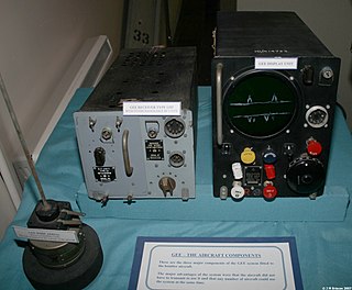
<span class="mw-page-title-main">Gee (navigation)</span> Radio navigation system

Gee, sometimes written GEE, was a radio navigation system used by the Royal Air Force during World War II. It measured the time delay between two radio signals to produce a fix, with accuracy on the order of a few hundred metres at ranges up to about 350 miles (560 km). It was the first hyperbolic navigation system to be used operationally, entering service with RAF Bomber Command in 1942.

<span class="mw-page-title-main">Direction finding</span> Measurement of the direction from which a received signal was transmitted

Direction finding (DF), or radio direction finding (RDF), is the use of radio waves to determine the direction to a radio wave source. The source may be a cooperating radio transmitter or may be an inadvertant source, a naturally-occurring radio source, or an illicit or enemy system. Radio direction finding differs from radar in that only the direction is determined by any one receiver; a radar system usually also gives a distance to the object of interest, as well as direction. By triangulation, the location of a radio source can be determined by measuring its direction from two or more locations. Radio direction finding is used in radio navigation for ships and aircraft, to locate emergency transmitters for search and rescue, for tracking wildlife, and to locate illegal or interfering transmitters. During the Second World War, radio direction finding was used by both sides to locate and direct aircraft, surface ships, and submarines.

<span class="mw-page-title-main">Oboe (navigation)</span> British bomb aiming system

Oboe was a British bomb aiming system developed to allow their aircraft to bomb targets accurately in any type of weather, day or night. Oboe coupled radar tracking with radio transponder technology. The guidance system used two well-separated radar stations to track the aircraft. Two circles were created before the mission, one around each station, such that they intersected at the bomb drop point. The operators used the radars, aided by transponders on the aircraft, to guide the bomber along one of the two circles and drop the bombs when they reached the intersection.

Gee-H, sometimes written G-H or GEE-H, was a radio navigation system developed by Britain during World War II to aid RAF Bomber Command. The name refers to the system's use of the earlier Gee equipment, as well as its use of the "H principle" or "twin-range principle" of location determination. Its official name was AMES Type 100.

A blind approach beacon system or beam approach beacon system (BABS) is an automatic radar landing system developed in the early 1940s.

<span class="mw-page-title-main">Rebecca/Eureka transponding radar</span> World War II airborne radio transponder system

The Rebecca/Eureka transponding radar was a short-range radio navigation system used for the dropping of airborne forces and their supplies. It consisted of two parts, the Rebecca airborne transceiver and antenna system, and the Eureka ground-based transponder. Rebecca calculated the range to the Eureka based on the timing of the return signals, and its relative position using a highly directional antenna. The 'Rebecca' name comes from the phrase "Recognition of beacons". The 'Eureka' name comes from the Greek word meaning "I have found it!".

The Lorenz beam was a blind-landing radio navigation system developed by C. Lorenz AG in Berlin. The first system had been installed in 1932 at Berlin-Tempelhof Central Airport, followed by Dübendorf in Switzerland (1934) and others all over the world. The Lorenz company referred to it simply as the Ultrakurzwellen-Landefunkfeuer, German for "ultra-short-wave landing radio beacon", or LFF. In the UK it was known as Standard Beam Approach (SBA).

<span class="mw-page-title-main">RAF Lindholme</span> Royal Air Force base in Yorkshire, England

Royal Air Force Lindholme or more simply RAF Lindholme is a former Royal Air Force station in South Yorkshire, England. It was located 3.9 miles (6.3 km) south of Thorne and 6.9 miles (11.1 km) north east of Doncaster and was initially called RAF Hatfield Woodhouse.

<span class="mw-page-title-main">Radio</span> Technology of using radio waves to carry information

Radio is the technology of signaling and communicating using radio waves. Radio waves are electromagnetic waves of frequency between 3 hertz (Hz) and 300 gigahertz (GHz). They are generated by an electronic device called a transmitter connected to an antenna which radiates the waves, and received by another antenna connected to a radio receiver. Radio is widely used in modern technology, in radio communication, radar, radio navigation, remote control, remote sensing, and other applications.

During World War II, the German Luftwaffe relied on an increasingly diverse array of electronic communications, IFF and RDF equipment as avionics in its aircraft and also on the ground. Most of this equipment received the generic prefix FuG for Funkgerät, meaning "radio equipment". Most of the aircraft-mounted Radar equipment also used the FuG prefix. This article is a list and a description of the radio, IFF and RDF equipment.

<span class="mw-page-title-main">Low-frequency radio range</span> Navigation system formerly used by aircraft

The low-frequency radio range, also known as the four-course radio range, LF/MF four-course radio range, A-N radio range, Adcock radio range, or commonly "the range", was the main navigation system used by aircraft for instrument flying in the 1930s and 1940s, until the advent of the VHF omnidirectional range (VOR), beginning in the late 1940s. It was used for en route navigation as well as instrument approaches and holds.

C. Lorenz AG (1880–1958) was a German electrical and electronics firm primarily located in Berlin. It innovated, developed, and marketed products for electric lighting, telegraphy, telephony, radar, and radio. It was acquired by ITT in 1930 and became part of the newly founded company Standard Elektrik Lorenz (SEL) Stuttgart in 1958, when it merged with Standard Elektrizitätsgesellschaft and several other smaller companies owned by ITT. In 1987, SEL merged with the French companies Compagnie Générale d'Electricité and Alcatel to form the new Alcatel SEL.

The Blind Landing Experimental Unit, abbreviated BLEU, was a unit of the British government tasked with creating an early autolanding system for military and civilian aircraft from the late 1940s until the mid-1960s.

<span class="mw-page-title-main">AI Mark VIII radar</span> Type of air-to-air radar

Radar, Airborne Interception, Mark VIII, or AI Mk. VIII for short, was the first operational microwave-frequency air-to-air radar. It was used by Royal Air Force night fighters from late 1941 until the end of World War II. The basic concept, using a moving parabolic antenna to search for targets and track them accurately, remained in use by most airborne radars well into the 1980s.

The Diamond-Dunmore system was an early blind landing system developed by Harry Diamond and Francis Dunmore at the National Bureau of Standards in the late 1920s. It was similar to the beam landing systems being developed in the UK and Germany shortly thereafter, but had the added advantage that the directional signal was automatically decoded and displayed on a cockpit indicator, rather than requiring the attention of a radio operator. It also added an optional vertical guidance system to provide a glideslope indication. In spite of the advanced nature of the system, or perhaps because of it, the system does not appear to have been widely used. In contrast, the simpler Lorenz system was widely deployed in Europe.

References

Citations

  1. 1 2 3 4 Lake 1999, p. 37.
  2. 1 2 Lake 1999, p. 38.
  3. 1 2 3 4 Lake 1999, p. 92.
  4. 1 2 Lake 1999, p. 93.
  5. 1 2 Lake 1999, p. 94.
  6. 1 2 3 Lake 1999, p. 36.

Bibliography