List of Grade A listed buildings in County Down

Last updated

County Down within Ireland Location of County Down on island of Ireland.png
County Down within Ireland
Map all coordinates using: OpenStreetMap  
Download coordinates as: KML

This is a list of Grade A listed buildings in County Down, Northern Ireland.

Contents

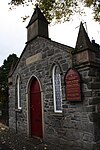
In Northern Ireland, the term listed building refers to a building or other structure officially designated as being of "special architectural or historic interest". [1] Grade A structures are those considered to be "buildings of greatest importance to Northern Ireland including both outstanding architectural set-pieces and the least altered examples of each representative style, period and type." [2] Once listed, severe restrictions are imposed on the modifications allowed to a building's structure or its fittings. Listed building consent must be obtained from local authorities prior to any alteration to such a structure. [1]

Listing began later in Northern Ireland than in the rest of the UK: the first provision for listing was contained in the Planning (Northern Ireland) Order 1972; [3] and the current legislative basis for listing is the Planning (Northern Ireland) Order 1991. [2] Under Article 42 of the Order, the relevant Department of the Northern Ireland Executive is required to compile lists of buildings of "special architectural or historic interest". Since 2016, the responsibility for the listing process rests with the Historic Environment Division of the Department for Communities (DfC). [4]

Following the introduction of listing, an initial survey of Northern Ireland's building stock was begun in 1974. [5] By the time of the completion of this First Survey in 1994, the listing process had developed considerably, and it was therefore decided to embark upon a Second Survey, which is still ongoing, to update and cross-check the original information. Information gathered during this survey, relating to both listed and unlisted buildings, is entered into the publicly accessible Northern Ireland Buildings Database. [5] A range of listing criteria, which aim to define architectural and historic interest, are used to determine whether or not to list a building. [2]

County Down covers 2,448 square kilometres (945 sq mi), and has a population of around 516,000. The County has 41 Grade A listed buildings.

Listed buildings

Notes

  1. Sometimes known as OSGB36, the grid reference is based on the British national grid reference system used by the Ordnance Survey.
  2. The type of structure, as identified by the DfC.
  3. The "HB Number" is a unique number assigned to each listed building by the DfC.
  4. The 19th-century house, not the 16th-century tower

Related Research Articles

Downpatrick Town in Northern Ireland

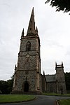
Downpatrick is a town in County Down, Northern Ireland. It is on the Lecale peninsula, about 21 mi (34 km) south of Belfast. In the Middle Ages, it was the capital of the Dál Fiatach, the main ruling dynasty of Ulaid. Its cathedral is said to be the burial place of Saint Patrick. Today, it is the county town of Down and the joint headquarters of Newry, Mourne and Down District Council. Downpatrick had a population of 10,822 according to the 2011 Census.

Newtownards Town in County Down, Northern Ireland

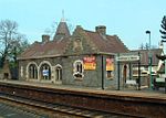
Newtownards is a town in County Down, Northern Ireland. It lies at the most northern tip of Strangford Lough, 10 miles (16 km) east of Belfast, on the Ards Peninsula. It is in the civil parish of Newtownards and the historic baronies of Ards Lower and Castlereagh Lower. Newtownards is in the Ards and North Down Borough. The population was 28,050 in the 2011 Census.

County Down County in Northern Ireland

County Down is one of the six counties of Northern Ireland, one of the nine counties of Ulster and one of the traditional thirty-two counties of Ireland. It covers an area of 961 sq mi (2,490 km2) and has a population of 531,665. It borders County Antrim to the north, the Irish Sea to the east, County Armagh to the west, and County Louth across Carlingford Lough to the southwest.

Ardglass Human settlement in Northern Ireland

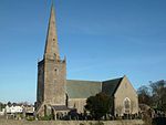
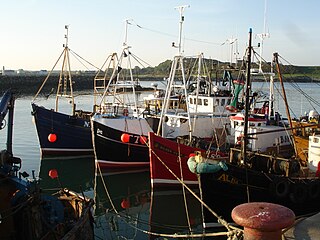
Ardglass is a coastal fishing village, townland and civil parish in County Down, Northern Ireland, in the historic barony of Lecale Lower. It is still a relatively important fishing harbour. It is situated on the B1 Ardglass to Downpatrick road, about 6 miles to the south east of Downpatrick, in the Lecale peninsula on the Irish Sea. It had a population of 1,668 in the 2001 Census, and is located within the Newry, Mourne and Down area.

Killyleagh Human settlement in Northern Ireland

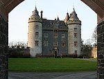
Killyleagh is a village and civil parish in County Down, Northern Ireland. It is on the A22 road between Belfast and Downpatrick, on the western side of Strangford Lough. It had a population of 2,483 people in the 2001 Census. It is best known for its twelfth century Killyleagh Castle. Killyleagh lies within the Newry, Mourne and Down district.

Down District Council District Council in Northern Ireland

Down District Council was a Local Council in County Down in Northern Ireland. It merged with Newry and Mourne District Council in April 2015 under local government reorganisation in Northern Ireland to become Newry, Mourne and Down District Council.

Roman Catholic Diocese of Down and Connor Latin Catholic diocese in Northern Ireland

The Diocese of Down and Connor, is a Latin Church ecclesiastical territory or diocese of the Catholic Church in Northern Ireland. It is one of eight suffragan dioceses in the ecclesiastical province of the metropolitan Archdiocese of Armagh. The present bishop is Noel Treanor.

The High Sheriff of Down is the Sovereign's judicial representative in County Down. Initially an office for lifetime, assigned by the Sovereign, the High Sheriff became annually appointed from the Provisions of Oxford in 1258. Besides his judicial importance, he has ceremonial and administrative functions and executes High Court Writs.

Castlereagh Lower Place in Northern Ireland, United Kingdom

Castlereagh Lower is a historic barony in County Down, Northern Ireland. It was created by 1841 with the division of Castlereagh into two. The barony roughly matches the former Gaelic territory of Uí Blathmaic, anglicized Blathewic. It is bordered by three other baronies: Ards Lower to the east; Dufferin to the south; and Castlereagh Upper to the west and south-west. Castlereagh Lower is also bounded by Belfast Lough to the north and Strangford Lough to the south-east.

References

  1. 1 2 "Planning Policy Statement 6: Planning, Archaeology, and the Built Heritage" (PDF). Planning Service. March 1999. p. 22. Retrieved 30 June 2010.
  2. 1 2 3 "Planning Policy Statement 6 Planning, Archaeology and the Built Heritage Revised Annex C: Criteria for Listing" (.pdf). DOENI. 2011. Retrieved 8 February 2017.
  3. Legislation providing for the listing of buildings in England, Wales and Scotland was enacted in 1947.
  4. "Structure and Contents in the Historic Environment Division" (PDF). Department for Communities. December 2016. Archived from the original (PDF) on 5 January 2017. Retrieved 8 February 2017.
  5. 1 2 "Second Survey". Department for Communities. Retrieved 8 February 2017.
  6. Portaferry Presbyterian Church, Meeting House Street, Portaferry: Historic Building Details. Northern Ireland Buildings Database. Northern Ireland Environment Agency. Retrieved 2010-07-05.
  7. Rosemount House, Rosemount, Greyabbey: Historic Building Details. Northern Ireland Buildings Database. Northern Ireland Environment Agency. Retrieved 2010-07-05.
  8. Ballywalter Park House and garden walling, Ballywalter: Historic Building Details. Northern Ireland Buildings Database. Northern Ireland Environment Agency. Retrieved 2010-07-05.
  9. The Temple of the Winds, Mount Stewart, Newtownards : Historic Building Details. Northern Ireland Buildings Database. Northern Ireland Environment Agency. Retrieved 2010-07-05.
  10. Mount Stewart and garden walls, Newtownards : Historic Building Details. Northern Ireland Buildings Database. Northern Ireland Environment Agency. Retrieved 2010-07-05.
  11. The Manor House, High Street, Donaghadee: Historic Building Details. Northern Ireland Buildings Database. Northern Ireland Environment Agency. Retrieved 2010-07-05.
  12. St. Mark's (Church of Ireland) Parish Church, Church Street, Newtownards: Historic Building Details. Northern Ireland Buildings Database. Northern Ireland Environment Agency. Retrieved 2010-07-05.
  13. Moyallen Friends Meeting House, 117 Stramore Road, Gilford: Historic Building Details. Northern Ireland Buildings Database. Northern Ireland Environment Agency. Retrieved 2010-07-05.
  14. Cleland Mausoleum, Dundonald Parish Graveyard, Dundonald: Historic Building Details. Northern Ireland Buildings Database. Northern Ireland Environment Agency. Retrieved 2010-06-30.
  15. Knockbreda Church (Church of Ireland), Church Road, Knockbreda: Historic Building Details. Northern Ireland Buildings Database. Northern Ireland Environment Agency. Retrieved 2010-06-30.
  16. Waringstown House, Magherana, Waringstown: Historic Building Details. Northern Ireland Buildings Database. Northern Ireland Environment Agency. Retrieved 2010-07-05.
  17. Killyleagh Castle, Killyleagh: Historic Building Details. Northern Ireland Buildings Database. Northern Ireland Environment Agency. Retrieved 2010-07-05.
  18. The Bawn, Killyleagh Castle: Historic Building Details. Northern Ireland Buildings Database. Northern Ireland Environment Agency. Retrieved 2010-07-05.
  19. Gatehouse Screen at Killyleagh Castle: Historic Building Details. Northern Ireland Buildings Database. Northern Ireland Environment Agency. Retrieved 2010-07-05.
  20. North East Gateway, Killyleagh Castle: Historic Building Details. Northern Ireland Buildings Database. Northern Ireland Environment Agency. Retrieved 2010-07-05.
  21. Rademon Unitarian Meeting House, Listooder Road, Rademan Crossgar Downpatrick: Historic Building Details. Northern Ireland Buildings Database. Northern Ireland Environment Agency. Retrieved 2010-07-05.
  22. Castleward House, Castleward, Strangford, Downpatrick: Historic Building Details. Northern Ireland Buildings Database. Northern Ireland Environment Agency. Retrieved 2010-07-05.
  23. Southwell Charity School and Almshouses, English Street, Downpatrick: Historic Building Details. Northern Ireland Buildings Database. Northern Ireland Environment Agency. Retrieved 2010-07-05.
  24. Downpatrick First (Non-Subscribing) Presbyterian Church, Stream Street, Downpatrick : Historic Building Details. Northern Ireland Buildings Database. Northern Ireland Environment Agency. Retrieved 2010-07-05.
  25. Holy Trinity Cathedral, English Street, Downpatrick: Historic Building Details. Northern Ireland Buildings Database. Northern Ireland Environment Agency. Retrieved 2010-07-05.
  26. Cathedral of St. Patrick and St. Colman, Hill Street, Newry : Historic Building Details. Northern Ireland Buildings Database. Northern Ireland Environment Agency. Retrieved 2010-07-05.
  27. Parish Church of St. Mary (Church of Ireland), John Mitchel Place, Newry: Historic Building Details. Northern Ireland Buildings Database. Northern Ireland Environment Agency. Retrieved 2010-07-05.
  28. Ross Monument, Warrenpoint Road, Rostrevor: Historic Building Details. Northern Ireland Buildings Database. Northern Ireland Environment Agency. Retrieved 2010-07-05.
  29. Narrow Water Castle, Newry Road, Warrenpoint : Historic Building Details. Northern Ireland Buildings Database. Northern Ireland Environment Agency. Retrieved 2010-07-05.
  30. Derrymore House, Bessbrook Newry BT35 7EF: Historic Building Details. Northern Ireland Buildings Database. Northern Ireland Environment Agency. Retrieved 2010-07-05.
  31. Rathmoyle, Craigdarragh Road, Helen's Bay, Bangor: Historic Building Details. Northern Ireland Buildings Database. Northern Ireland Environment Agency. Retrieved 2010-07-05.
  32. Bangor Old Custom House, Quay Street, Bangor: Historic Building Details. Northern Ireland Buildings Database. Northern Ireland Environment Agency. Retrieved 2010-07-05.
  33. Helen's Tower, Conlig: Historic Building Details. Northern Ireland Buildings Database. Northern Ireland Environment Agency. Retrieved 2010-07-05.
  34. Town Hall, Bangor Castle, Bangor: Historic Building Details. Northern Ireland Buildings Database. Northern Ireland Environment Agency. Retrieved 2010-07-05.
  35. Local Heritage and Visitor's Centre, Bangor Castle, Bangor: Historic Building Details. Northern Ireland Buildings Database. Northern Ireland Environment Agency. Retrieved 2010-07-05.
  36. Bangor Abbey Parish Church, Bangor: Historic Building Details. Northern Ireland Buildings Database. Northern Ireland Environment Agency. Retrieved 2010-07-05.
  37. 3 Station Square, Helen's Bay: Historic Building Details. Northern Ireland Buildings Database. Northern Ireland Environment Agency. Retrieved 2010-07-05.
  38. Station Building, Helen's Bay Station, Helen's Bay: Historic Building Details. Northern Ireland Buildings Database. Northern Ireland Environment Agency. Retrieved 2010-07-05.
  39. Station Platforms, Helen's Bay Station: Historic Building Details. Northern Ireland Buildings Database. Northern Ireland Environment Agency. Retrieved 2010-07-05.
  40. Railway Bridge, Helen's Bay Station: Historic Building Details. Northern Ireland Buildings Database. Northern Ireland Environment Agency. Retrieved 2010-07-05.
  41. Coach Yard, Helen's Bay Station: Historic Building Details. Northern Ireland Buildings Database. Northern Ireland Environment Agency. Retrieved 2010-07-05.
  42. Parish Church Of St. Malachi, Main Street, Hillsborough: Historic Building Details. Northern Ireland Buildings Database. Northern Ireland Environment Agency. Retrieved 2010-07-05.
  43. Gate screen and lodges (aka Sexton's House) at Parish Church Of St. Malachi, Hillsborough: Historic Building Details. Northern Ireland Buildings Database. Northern Ireland Environment Agency. Retrieved 2010-07-05.
  44. Marquis of Downshire Monument, Monument Road, Hillsborough: Historic Building Details. Northern Ireland Buildings Database. Northern Ireland Environment Agency. Retrieved 2010-07-05.
  45. Larchfield House, Upper Ballynahinch Road, Lisburn: Historic Building Details. Northern Ireland Buildings Database. Northern Ireland Environment Agency. Retrieved 2010-07-05.
  46. St. John's Parish Church, Moira: Historic Building Details. Northern Ireland Buildings Database. Northern Ireland Environment Agency. Retrieved 2010-07-05.
Map all coordinates using: OpenStreetMap  
Download coordinates as: KML