Location of sites

The United Nations Educational, Scientific and Cultural Organization (UNESCO) established in 1972 is engaged in the protection and preservation of cultural or natural heritage. [1]
There are 7 UNESCO World Heritage Sites in Saudi Arabia inscribed from 2008 to 2023.
| Name | Image | Location | Date | UNESCO Data | Description |
|---|---|---|---|---|---|
| Al-Ahsa Oasis |  | Al-Ahsa Oasis | Neolithic | ; 2018; iii, iv, v;(Cultural) | The Al-Ahsa Oasis is a serial property comprising gardens, canals, springs, wells and a drainage lake, as well as historical buildings, urban fabric and archaeological sites. [2] |
| Al-Hijr Archaeological Site (Madâin Sâlih) |  | Al-'Ula | The 1st century BC | ;2008;ii, iii;(Cultural) | The Archaeological Site of Al-Hijr (Madâin Sâlih) features well-preserved monumental tombs with decorated facades dating from the 1st century BC to the 1st century AD. The site also features some 50 inscriptions of the pre-Nabataean period and some cave drawings. [3] |
| At-Turaif District in Diriyah |  | Diriyah | The 15th century | ; 2010; iv, v, vi;(Cultural) | Al-Turaif District bears witness to the Najdi architectural style, which is specific to the centre of the Arabian peninsula and includes the remains of many palaces and an urban ensemble built on the edge of the ad-Dir’iyah oasis. [4] |
| Ḥimā Cultural Area |  | Najran Province | The time period of 7000–1000 BC | ;2021; iii;(Cultural) | Ḥimā Cultural Area contains a collection of rock art images illustrating hunting, fauna, flora and lifestyles of 7,000 years. [5] |
| Historic Jeddah, the Gate to Makkah |  | Jeddah | The 7th century AD | ;2014; ii, iv, vi;(Cultural) | Historic Jeddah was as a major port for Indian Ocean trade routes, channelling goods to Mecca. It was also the gateway for Muslim pilgrims to Mecca who arrived by sea. [6] |
| Rock Art in the Hail Region |  | Hail Region | From 10,000 years [7] | ;2015; i, iii;(Cultural) | This property shows numerous representations of human and animal figures covering 10,000 years of history. [7] |
| ‘Uruq Bani Mu’arid Protected Area |  | Najran, Riyadh 19°20′13″N45°54′14″E / 19.337°N 45.904°E | ;2023; vii, ix;(Natural) | The property encompasses the western part of the greatest expanse of windblown sand on Earth, known as Ar Rub' al-KhaIi, and conserves one of the Earth’s most spectacular desert landscapes. [8] | |
| Site | Image | Location | Criteria | Area ha (acre) | Year of submission | Description |
|---|---|---|---|---|---|---|
| Zee Ain Heritage Village in Al-Baha Region |  | Al Balah , 19°46′03″N41°26′03″E / 19.767444°N 41.434222°E | Cultural (iv)(v) | 2015 | Characterized by traditional stone architecture and features stone-built houses and a historic mosque, illustrating the adaptation of its inhabitants to the mountainous environment and their emphasis on community and defense. The surrounding agricultural terraces showcase early farming techniques and water management. [9] | |
| Rijal Almaa Heritage Village in Assir Region |  | 'Asir , 18°12′46″N42°16′24″E / 18.212778°N 42.273333°E | Cultural (iv)(v) | 2015 | A historical village renowned for its distinctive clay and stone tower houses. This village, which consists of about 60 multi-story buildings, showcases the unique architectural style of the Assir region, featuring brightly colored facades and intricate wooden window frames. [10] | |
| Egyptian Hajj Road |  | Madihan , Makkah, Tabuk 28°29′18″N34°59′56″E / 28.48847°N 34.99875°E | Cultural (ii) (iv)(v) | 2015 | The road served as a pilgrimage route for Hajj travelers from Egypt to Mecca. This ancient path was part of a network of routes facilitating the annual Islamic pilgrimage, accommodating the logistical needs of travelers with rest stations, wells, and forts for protection against the harsh desert conditions and potential threats. Over centuries, it played a crucial role in the religious, cultural, and economic exchanges between regions. [11] | |
| Syrian Hajj Road |  | Madihan , Makkah, Tabuk 29°02′51″N36°10′10″E / 29.04737°N 36.16931°E | Cultural (ii) (iv)(v) | 2015 | A route for Hajj pilgrims traveling from Syria to Mecca. It featured a network of roads with facilities like caravanserais and water sources, ensuring the safety and well-being of travelers. This route facilitated not only religious journeys but also cultural and economic exchanges between regions. [12] | |
| Hejaz Railway |  | Madihan , Tabuk 29°08′19″N36°04′50″E / 29.13864°N 36.08054°E | Cultural (ii) (iv)(vi) | 2015 | A historic rail line originally built to facilitate the pilgrimage to Mecca, connecting Damascus in Syria to Medina in Saudi Arabia. Beyond its religious significance, the railway also served strategic and economic purposes, enhancing the Ottoman Empire's control over its distant provinces and fostering trade. [13] | |
| Farasan Islands Protected Area | 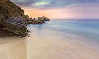 | Jazan 16°48′N41°51′E / 16.8°N 41.85°E | Natural (x) | 2019 | A conservation site in Saudi Arabia, located in the Red Sea. It encompasses a group of islands known for their rich biodiversity, including coral reefs, mangroves, and a variety of marine and bird life. The area is particularly known for its nesting populations of birds and its significance as a habitat for endangered species. The islands also hold archaeological sites and cultural heritage, reflecting a long history of human habitation. [14] | |
| The Hajj Pilgrimage Routes: The Darb Zubaydah |  | Ḥa'il,Madihan, Makkah, Northern Borders, Qassim 24°37′55″N41°17′26″E / 24.6319°N 41.2906°E | Cultural (ii)(iv)(vi) | 2022 | From Kufa in Iraq to Mecca in Saudi Arabia. This ancient pathway was named after Zubaydah bint Ja`far, the wife of the Abbasid Caliph Harun al-Rashid, who significantly contributed to its development by constructing wells, reservoirs, and rest stations to support the pilgrims. The route facilitated safer and more manageable journeys for thousands of Hajj pilgrims through the harsh desert landscape. [15] | |
| The Ancient Walled Oases of Northern Arabia |  | Al Jawf, Ḥa'il, Tabuk, 27°37′47″N38°32′38″E / 27.629722°N 38.543889°E | Cultural (ii)(v) | 2022 | A series of fortified settlements that flourished in the harsh desert environment of the Arabian Peninsula. They served as hubs for trade, agriculture, and settlement, thanks to their strategic locations along ancient caravan routes and their ability to sustain life through sophisticated water management systems. The walls that surrounded them provided protection against raiders and helped control the microclimate for agriculture, making them vital centers for the development of early Arabian societies. [16] | |
| The Cultural Landscape of Al-Faw Archaeological Area |  | Riyadh 19°46′56″N45°08′54″E / 19.782319°N 45.148231°E | Cultural (ii)(iv)(v) | 2022 | Once a major city known as ancient Qaryat al-Faw, it served as a trading hub linking the Arabian Peninsula with neighboring regions. This area showcases a blend of residential, commercial, and religious structures, highlighting advanced urban planning and architectural techniques of the time. [17] | |
| The Rural Cultural Landscapes of Sarawat Mountains |  | Al-Bahah, 'Asir, Makkah 20°48′16″N40°45′21″E / 20.804383°N 40.755842°E | Cultural (ii)(iii)(v) | 2023 | Traditional villages and agricultural terraces. These landscapes highlight sustainable living through stone and mud-brick houses and terraced farming, which utilizes scarce water efficiently. This region embodies the cultural heritage and agricultural traditions of its inhabitants, reflecting centuries of sustainable practices and community resilience in challenging environments. [18] | |
| The Oil Industrial Heritage in Saudi Arabia |  | Eastern Province, Makkah 26°19′15″N50°07′38″E / 26.320917°N 50.127294°E | Cultural (ii)(iv)(v) | 2023 | Historic oil fields, refineries, and industrial sites that mark the beginning of oil exploration and production in the early 20th century. These sites not only represent technological advancements but also the socio-economic changes that oil discovery brought to Saudi Arabia, turning it into a key player in the global energy market. [19] | |
| Coral Reefs of the Gulf of Aqaba and the Red Sea in the Kingdom of Saudi Arabia |  | Tabuk 28°13′52″N34°38′44″E / 28.230998°N 34.645570°E | Natural (viii)(ix)(x) | 2024 | Home to a wide variety of coral species, fish, and other marine organisms. They play a crucial role in marine life support, local fishing industries, and the tourism sector. [20] | |

Riyadh is the capital and largest city of Saudi Arabia. It is also the capital of the Riyadh Province and the centre of the Riyadh Governorate. The current form of the metropolis emerged as an offshoot of the eponymous walled town following the dismantling of its defensive fortifications in the 1950s, after which the city underwent several phases of expansion and urbanization.

Jeddah, alternatively transliterated as Jedda, Jiddah or Jidda, is a port city in Makkah Province, Saudi Arabia, located along the Red Sea coast in the Hejaz region. Jeddah is the commercial center of the country. It is not known when Jeddah was founded, but Jeddah's prominence grew in 647 when the Caliph Uthman made it a travel hub serving Muslim travelers going to the holy city of Mecca for Islamic pilgrimage. Since those times, Jeddah has served as the gateway for millions of pilgrims who have arrived in Saudi Arabia, traditionally by sea and recently by air.

The Eastern Province, also known as the Eastern Region, is the easternmost of the 13 provinces of Saudi Arabia. It is the nation's largest province by area and the third most populous after the Riyadh and Mecca provinces. In 2017, the population was 4,900,325. Of these, 3,140,362 were Saudi citizens and 1,759,963 were foreign nationals The province accounts for 15.05% of the entire population of Saudi Arabia and is named for its geographical location relative to the rest of the kingdom.
Al-Balad, also known as Jeddah Historic District, is the historical area of Jeddah, the second largest city of Saudi Arabia. Al-Balad can literally be translated to "The Town". Al-Balad is the historic center of the City of Jeddah.

Al Ahsa also known as Hajar is the largest governorate in Saudi Arabia's Eastern Province, named after the Al-Ahsa Oasis. In Classical Arabic, 'Ahsa' means the sound of water underground. It has one of the largest oases in the world with world-renowned date palms and, according to one author, the oases of Al-Hasa and Al Ain are the most important in the Arabian Peninsula. The oasis is located about 60 mi (97 km) inland from the Arabian Gulf. All urban areas are located in the traditional oasis of Al-Hasa. In addition to the oasis, the county also includes the giant Empty Quarter desert, making it the largest governorate in Saudi Arabia in terms of area. The Empty Quarter has the world's largest oil fields, and connects Saudi Arabia to Qatar, the UAE, and Oman. The Governorate's population is over 1,100,000. In the past, Al-Ahsa belonged to the historical region known as Bahrain, along with Qatif and the present-day Bahrain islands.
Al-Ahsa Oasis, also known as al-Ḥasāʾ (الْحَسَاء) or Hajar (هَجَر), is an oasis and historical region in eastern Saudi Arabia. Al-Ahsa Governorate, which makes up much of the country's Eastern Province, is named after it. The oasis is located about 60 km (37 mi) inland from the coast of the Persian Gulf. Al-Ahsa Oasis comprises four main cities and 22 villages. The cities include Al-Mubarraz and Al-Hofuf, two of the largest cities in Saudi Arabia.
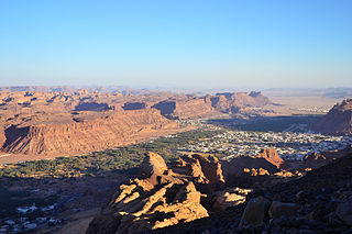
Al-Ula is an ancient Arabic oasis city located in Medina Province, Saudi Arabia. Situated in the Hejaz, a region that features prominently in the history of Islam as well as several pre-Islamic Semitic civilizations, al-‘Ulā was a market city on the historic incense route that linked India and the Persian Gulf to the Levant and Europe.

Hegra, also known as Mada’in Salih, is an archaeological site located in the area of Al-'Ula within Medina Province in the Hejaz region, Saudi Arabia. A majority of the remains date from the Nabataean Kingdom. The site constitutes the kingdom's southernmost and second largest city after Petra, its capital city. Traces of Lihyanite and Roman occupation before and after the Nabatean rule, respectively, can also be found.

Saudi Arabia is the second biggest tourist destination in the Middle East with over 16 million visiting in 2017. Although most tourism in Saudi Arabia still largely involves religious pilgrimages, there is growth in the leisure tourism sector. As the tourism sector has been largely boosted lately, the sector is expected to a significant industry for Saudi Arabia, reducing its dependence on oil revenues. This is proved as tourism sector is expected to generate $25 billion in 2019. Potential tourist areas include the Hijaz and Sarawat Mountains, Red Sea diving and a number of ancient ruins.
Saudi Arabian art is contextual to the country being the birthplace of Islam; it includes both the arts of Bedouin nomads and those of the sedentary peoples of regions such as the Hejaz, Tihamah, Asir and Najd.

'Uruq Bani Ma'arid is a protected area in southern Saudi Arabia, located on the western edge of the Rub' al Khali, the largest sandy desert in the world. The protected area is divided into three sections; a core nature reserve; a zone where controlled grazing is permitted; and a hunting zone.
Al-AsfarLake, also known as Asfar, Alasfar and Yellow Lake. Al-Asfar is located to the East of Umran city, in Al-Hasa, Eastern Saudi Arabia. The lake is surrounded by sand dunes and somewhat difficult to reach. Al-Asfar lake is one of the most important wetland shallow lakes in the region. The lake is a historic landmark of Al-Hasa, and was mentioned by some historians of the Abbasid and Islamic Golden Era such as Al-Hamawi, Al-Qalqashandi and Al-Zamakhshari. In the present time, The primary source of lake water is agricultural drainage water, which made some to refer to it as man-made. in 2019, Yellow Lake was declared national nature reserve.

At-Turaif is a historic district located in Ad-Dir'iyah, north-west of Riyadh. It is regarded as one of the more important political and historical sites in Saudi Arabia, as it represented the capital of Saudi dynasty. It was the original home of the Saudi royal family and was the country's first capital from 1727 until Ottoman control of the area in 1818.
The Saudi Heritage Preservation Society (SHPS) is a Saudi charitable society established on 17 May 2010 and concerned with the preservation of national heritage where the constituent meeting was held in the National Museum of Saudi Arabia. It has been registered by UNESCO as an international nongovernmental organization in safeguarding heritage.
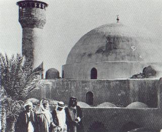
Qasr Ibrahim is a historic fort in the north of Alqoat neighborhood, Hofuf, Al-Ahsa, Eastern Province, Saudi Arabia. It is also called the Dome Palace, AlQoat Palace or Ibrahim Castle and is the region's main architectural heritage site from the Ottoman period. It served as a Turkish military base. It was seized by King Abdul-Aziz Al Saud on April 13, 1913.
The Ministry of Tourism, before 2020 as the Saudi Commission for Tourism and National Heritage (SCTH), till 2015 as the Saudi Commission for Tourism and Antiquities (SCTA) and prior to 2008 as the Supreme Commission for Tourism (SCT), is a government ministry in Saudi Arabia that is concerned with the tourism sector of the country. Established in the year 2000 through a royal decree by King Fahd, it was transformed into a ministry in 2020.

Al-Qarah Mountain or Jabal Al-Qārah, also known as "Al-Shabaab Mountain", is a mesa of 75 metres in Al-Ahsa, in the Eastern Province of Saudi Arabia. This mountain counts as one of the most important natural sights in Al-Ahsa, and was registered in the UNESCO world heritage center's list in 2018, after the inclusion of Al-Ahsa Oasis. It is located 15 kilometres to the northeast of Al-Hofuf. Some of its caves, such as "Al-Nashab", have moderately steady temperatures throughout the year.