The United Nations Educational, Scientific and Cultural Organization (UNESCO) World Heritage Sites are places of importance to cultural or natural heritage as described in the UNESCO World Heritage Convention, established in 1972. [1] Cultural heritage consists of monuments (such as architectural works, monumental sculptures, or inscriptions), groups of buildings, and sites (including archaeological sites). Natural heritage is defined as physical and biological formations, geological and physiographical formations (including habitats of threatened flora and fauna), and sites which are important from the point of view of scientific research, conservation or natural aesthetic. [2]
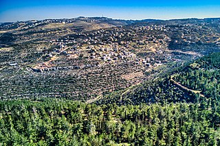
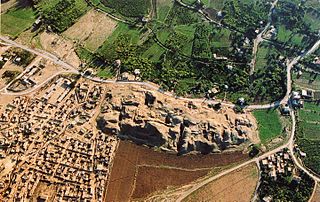
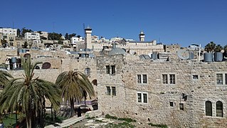
The State of Palestine accepted the convention on 8 December 2011, making its cultural and natural heritage sites eligible for inclusion on the list. As of 2024 [update] , there are five World Heritage Sites in Palestine, four in the West Bank (the Church of the Nativity as the Birthplace of Jesus and associated Pilgrimage Route in Bethlehem; Hebron's old town; Battir's Land of Olives and Vines as a Cultural Landscape of Southern Jerusalem; and Tell es-Sultan in ancient Jericho) and one in the Gaza Strip (Saint Hilarion Monastery/Tell Umm Amer). [3] Three are on UNESCO's List of World Heritage in Danger. [4] [5] [6] The Birthplace of Jesus site was once on the list from 2012 to 2019. [7] In addition, the Palestinian government has put 13 sites on its tentative list, meaning they intend to nominate them as World Heritage Sites sometime in the future. [3]
The Hashemite Kingdom of Jordan proposed the Old City of Jerusalem and its Walls, located in East Jerusalem, to be listed as a World Heritage Site. The site is not assigned to a state on the UNESCO listing, [8] with respect to its disputed status on whether it belongs to the State of Israel or Palestine. In 2011 UNESCO stated that it "continues to work to ensure respect for the outstanding universal value of the cultural heritage of the Old City of Jerusalem. [...] In line with relevant UN resolutions, East Jerusalem remains part of the occupied Palestinian territory, and the status of Jerusalem must be resolved in permanent status negotiations." [9]
Due to the conflict between the two countries, Israel has been a vocal critic of Palestine's position in UNESCO since its plans to enter, and left the convention in 2019 with the United States, accusing it of being dismissive of their heritage. Tell-es-Sultan's inclusion as a Palestinian site was criticized by its Foreign Ministry as "another sign of Palestinians' cynical use of UNESCO and politicization of the organization" and wishes to revert the "distorted decisions". [10] Meanwhile, Palestine's Minister of Agriculture Riad Attari deemed the inclusion as a step toward their right to return. [11] Experts argued that the Israeli cabinet is the one politicizing UNESCO, with Israeli heritage organization Emek Shaveh noting that the part of Jericho claimed by Israel is not the one listed. [12] Prior to their leave, Israel has made gradual cuts in funding for the UNESCO in dismay towards the progression of Palestine's World Heritage List. [13]
UNESCO lists sites under ten criteria; each entry must meet at least one of the criteria. Criteria i through vi are cultural, and vii through x are natural. [14] Four sites are in the West Bank and one is in the Gaza Strip.
Site | Image | Governorate | UNESCO data | Year listed | Description |
---|---|---|---|---|---|
Ancient Jericho/Tell es-Sultan | Jericho Governorate | 1687; i, ii, iii, iv (cultural) | 2023 | This tell dates back to at least 10,500 BC, as well as the nearby village of Ein es-Sultan. During the 9th to 8th millennium BC, humans began permanently settling here due to the soils' fertility and accessible water. Surviving architectural works include a ha-ha and tower. The Bronze Age saw urban planning and the establishment of a Canaanite city-state. [15] It was in the tentative list on 4 February 2012. [16] | |
Birthplace of Jesus: Church of the Nativity and the Pilgrimage Route, Bethlehem | Bethlehem Governorate | 1433; iv, vi (cultural) | 2012 | Located 10 kilometres (6.2 miles) away from Jerusalem, Christianity widely regards a cave in Bethlehem as where Jesus was born. The nearby Church of the Nativity is the oldest regularly-used Christian church and has gained notoriety as a pilgrimage site. The main route from Jerusalem to Bethlehem which also extends to the Damascus Gate is seen as the path Jesus' parents Joseph and Mary used. [17] UNESCO immediately listed it as a World Heritage in Danger due to the church's poor condition, but removed it in 2019 with the extensive restoration done to its exterior. [7] It was previously in the tentative list on 8 March 2012. [18] | |
Hebron/Al-Khalil Old Town † | Hebron Governorate | 1565; ii, iv, vi (cultural) | 2017 | This town was established amid the Mamluk Sultanate (1250–1517) at an area known for its limestone. A pilgrimage site for Judaism, Christianity, and Islam, Hebron's landmark is the Cave of the Patriarchs, where Abraham and his family were allegedly buried. Once a trading hub for the nearby countries, it was expanded during the country's rule under the Ottoman Empire, although the Mamluk architecture persists. [5] The site was immediately listed as endangered due to persistent damage cases. [13] It was on the tentative list on 2 April 2012. [19] | |
Palestine: Land of Olives and Vines – Cultural Landscape of Southern Jerusalem, Battir † | Bethlehem Governorate | 1492; iv, v (cultural) | 2014 | Located between Hebron and Nablus, Battir's residents utilise the area's valleys and terraces for market garden, as well as farming grapevines and olive trees. Because of its mountainous location, underground irrigation channels were made to accommodate farmers, and an egalitarian distribution system is used to distribute water. The cultural landscape also comprises rock-cut tombs and watchtowers. [4] The impact of the Israeli–Palestinian conflict, exemplarily taking form in a border wall, may lead to a loss of heritage; thus, it was immediately listed endangered. [20] It was on the tentative list on 25 April 2012. [21] | |
Saint Hilarion Monastery/Tell Umm Amer | Deir al-Balah Governorate, Gaza Strip | 1749; ii, iii, vi (cultural) | 2024 | The area of Tell Umm Amer, located in the Al Nusairat village nearby Wadi Gaza, was first known as Tabatha from the 400 to 670, with a surviving landmark being the Saint Hilarion Monastery, named after the saint born there and regarded as founder of Palestinian monasticism; it was destroyed in 614. Various facilities and artworks were observed within the ruins, alongside baths to accommodate people taking the Via Maris route. It was on the tentative list since 2 April 2012, and on 26 July 2024 [22] [6] became a World Heritage in Danger in light of the bombing of the Gaza Strip since 2023. [23] |
Although listed without a specific state attributed, UNESCO acknowledges the area to be within Palestine, hence its inclusion here. [9]
Site | Image | Governorate | UNESCO data | Year listed | Description |
---|---|---|---|---|---|
Old City and Walls of Jerusalem † | Jerusalem Governorate | 148rev; ii, iii, vi (cultural) | 1981 | Jerusalem is a holy city for the three Abrahamic religions: Christianity, Islam, and Judaism, with one of its landmark, the 7th-century Islamic Dome of the Rock, recognised by all three as where Abraham was sacrificed. Other icons include the Western Wall, a worshipping site for Jews, and the Church of the Holy Sepulchre, whose rotunda is believed by Christians to be Jesus' burial site. [8] Proposed by Jordan in 1980, [24] the Old City was listed as endangered in 1982 with only the United States opposing. [25] In 2000, Israel published a tentative extension of the site, but due to its still-debated status, the proposal is put on hold. [26] |
In addition to sites inscribed on the World Heritage List, member states can maintain a list of tentative sites for nomination consideration. Nominations for the list are only accepted if the site had been on the tentative list. [27]
Site | Image | Location (governorate) | UNESCO data | Date listed | Description |
---|---|---|---|---|---|
Anthedon Harbour | Gaza Governorate, Gaza Strip | 5719; ii, iv (cultural) | 2 April 2012 | This site is Gaza's first seaport between 800 BC to 1100 AD. Nearby is the ancient Maiumas seaport, once dubbed the Harbour of Gaza and a thriving city under Roman rule. The exact location of Anthedon remains ambiguous, however a major theory is with a tell named Tida, which was also Anthedon's nickname. Excavations of the former city centre revealed a Roman temple, a series of villas, and various architectural works from the Iron Age II, Persian, Hellenistic, Roman and Byzantine eras. [28] | |
Baptism Site "Eshria'a" (Al-Maghtas) | Area C, Jericho Governorate, West Bank | 6155; iii, iv, vi (cultural) | 28 October 2015 | Located on the western bank of the Jordan River and the Jordan Rift Valley which houses various cultural heritage, this site is believed by Christians to be where John the Baptist baptized Jesus, thus considered to be their third holiest site. It began seeing popularity from the 1st century BC up to the 15th century AD. It has become the site for various baptism ceremonies and tourism among Christians. The eastern bank of the river is already a Jordanian World Heritage Site titled "Baptism Site "Bethany Beyond the Jordan" (Al-Maghtas)". [29] | |
El-Bariyah: wilderness with monasteries | Area C, Jericho Governorate, West Bank | 5708; i, ii, iii (cultural) | 2 April 2012 | Widely referred to as the Judaean Desert, this part of the Irano-Turanian Region has a unique formation, giving it low amounts of rainfall but also often experiencing flash floods. This makes El-Bariyah a diverse natural habitat, especially birds who migrate here. At Wadi Khureitun once stood houses, and several monasteries and maqams were discovered too. The site also includes Herodium, a Roman-era castle. [30] | |
Hisham's Palace/ Khirbet al-Mafjar | Jericho, Jericho Governorate, West Bank | 6546; i, ii (cultural) | 20 October 2020 | This site was allegedly built by Hisham ibn Abd al-Malik, hence its name, at Wadi Nueima between 724 and 743 amid the Umayyad Caliphate. A ski resort for the caliph, it was ruined by the 749 Galilee earthquake. During the caliphate and the Abbasid dynasty, the northern area was used for agriculture. The building features a star window that has become symbolic of Jericho. There was also an audience and banquet hall, a mosque, and a residential area. [31] | |
Mount Gerizim and the Samaritans | Nablus, Nablus Governorate, West Bank | 5706; iii, vi (cultural) | 2 April 2012 | Believers of Samaritanism identify Gerizim's main summit as where the Binding of Isaac occurred, and its temple as the correct holy site in lieu of the Temple Mount in Jerusalem. There was once a settlement area, and during the Roman Empire a temple of Zeus was built at the Tell er-Ras summit. A church was fortified in a religious revolt. The Samaritans continue to engage in rituals like the Passover sacrifice and making pilgrimages to the summit annually. [32] | |
Old Town of Nablus and its environs | Nablus Governorate, West Bank | 5714; ii, iv (cultural) | 2 April 2012 | The earliest documents on the Nablus area is an ancient urban city called Shechem established in the 4th millennium BC, with its only remains being in Tell Balata. After being abandoned during the Iron Age, it was reoccupied in the Hellenistic period and fully transitioned in 72 into Neapolis by the Flavian dynasty. It became a major city in the 2nd century; landmarks include a hippodrome and the Roman Temple of Zeus. The city was then reoccupied by the Mamluk Sultanate. In the 18th century after earthquakes destroyed the city, it was rebuilt as Nablus, a wordplay on Neapolis. It is considered endangered due to effects of the Israeli–Palestinian conflict. [33] | |
QUMRAN: Caves and Monastery of the Dead Sea Scrolls | Jericho Governorate, West Bank | 5707; iii, iv, vi (cultural) | 2 April 2012 | The Judeo-Christian sect Essenes lived in Qumran during the Greco-Roman period. The Dead Sea Scrolls detailed their culture and beliefs, a unique insight into Judaism and early Christianity in the area. The texts include the Community Rule, Damascus Document, and The War of the Sons of Light Against the Sons of Darkness . Excavations of reveal buildings like communal facilities, a library, and a cemetery, however the area is being occupied by Israel. [34] | |
Sebastia | Nablus, Nablus Governorate, West Bank | 5718; ii, v (cultural) | 2 April 2012 | The city that previously stood in this site, ancient Samaria, was once capital of the Kingdom of Israel. The Bible alleges that the land was acquired by Omri. Following the Assyrian people's reign, it was occupied in 332 BC by Alexander the Great, who fortified the city. After a revitalization by Pompey, Herod the Great ruled Sebastia and named it after the Greek name of Augustus who gave him the land. Various landmarks were then built. Christians and Muslims believe that the city houses the tomb of John the Baptist. The present city was the eastern part of the Roman city. [35] | |
Umm Al-Rihan forest | Jenin Governorate, West Bank | 5721; x (natural) | 2 April 2012 | Located nearby the Green Line, this 60,000-dunam site is the largest woodlands in the West Bank. Part of the Mediterranean Biogeographic Region, it is notable as a migration stopover for birds, including endangered ones like the lesser kestrel, crested honey buzzard, and Egyptian vulture. Fauna in the forest include endangered wolves and red foxes. Plant species include those responsible for barley and wheat. This diversity makes Umm Al-Rihan suitable for in situ conservation. [36] | |
Throne Villages | Ibwein, Arrabeh, Beit Wazan, Burqa, Deir Ghassaneh, Deir Istia, Dura, Jamma'in, Kur, Nelean, Ras Karkar, Sebastia and Sanur; West Bank | 5717; iii, iv (cultural) | 6 June 2013 | This site comprises the villages within Palestine's central highlands. In the 18th and 19th centuries, it was divided into 24 sheikhdoms: administrative regions ruled by sheikhs with wealthy or noble relations backed by the Ottoman Empire. They adopt feudalism and had a distinct architectural segregation between the sheikhs and the peasants: the former lived at higher altitudes, and have defensive walls built. [37] | |
Wadi Gaza Coastal Wetands | Gaza Strip | 5722; x (natural) | 2 April 2012 | Wadi Gaza is most identified with its plethora of meanders; notably, the part at the Gaza Strip border has eight. The river gradually widens as it nears its mouth which spans 100 meters. It is the meeting point of six other wadis. With Gaza being between Africa and Eurasia, this site is a common passage point for migratory birds, with the endemic Palestine sunbird being the most spotted one. It faces many environmental problems, most notably refugee camps using it as a landfill, and is critical to preservation. [38] | |
Wadi Natuf and Shuqba cave | Ramallah and al-Bireh Governorate, West Bank | 5712; ii, iii, iv (cultural) | 6 June 2013 | The Natufian culture is a Late Epipaleolithic archaeological culture discovered by the discovery of the Shuqba cave, which also revealed information on two major occupations: the Late Levallois-Mousterian and Late Natufian period. Their respective layers reveal tools like geometric microliths, as well as human burials. The people living there had a communal hunter-gatherer identity, a progression from the typical settler type, though they quickly transitioned to being agricultural. [39] |
Jericho is a city in the West Bank, Palestine; it is the administrative seat of the Jericho Governorate of Palestine. Jericho is located in the Jordan Valley, with the Jordan River to the east and Jerusalem to the west. In 2017, it had a population of 20,907.
World Heritage Sites are landmarks and areas with legal protection by an international convention administered by UNESCO for having cultural, historical, or scientific significance. The sites are judged to contain "cultural and natural heritage around the world considered to be of outstanding value to humanity".
<|-- ->
Battir is a Palestinian village in the Bethlehem Governorate of the State of Palestine, in the West Bank, 6.4 km west of Bethlehem, and southwest of Jerusalem. In 2017, the village had a population of 4,696.
The World Heritage Committee is a committee of the United Nations Educational, Scientific and Cultural Organization that selects the sites to be listed as UNESCO World Heritage Sites, including the World Heritage List and the List of World Heritage in Danger, defines the use of the World Heritage Fund and allocates financial assistance upon requests from States Parties. It comprises representatives from 21 state parties that are elected by the General Assembly of States Parties for a four-year term. These parties vote on decisions and proposals related to the World Heritage Convention and World Heritage List.
The United Nations Educational, Scientific and Cultural Organization is a specialized agency of the United Nations (UN) with the aim of promoting world peace and security through international cooperation in education, arts, sciences and culture. It has 194 member states and 12 associate members, as well as partners in the non-governmental, intergovernmental and private sector. Headquartered in Paris, France, UNESCO has 53 regional field offices and 199 national commissions.
Tell es-Sultan, also known as Tel Jericho or Ancient Jericho, is an archaeological site and a UNESCO World Heritage Site in the Palestine, in the city of Jericho, consisting of the remains of the oldest fortified city in the world.
The Tower of Jericho is an 8.5-metre-tall (28 ft) stone structure built in the Pre-Pottery Neolithic A period around 8000 BC. It is part of Tell es-Sultan, a UNESCO World Heritage Site in the State of Palestine, in the city of Jericho, consisting of the remains of the oldest fortified city in the world. The Tower of Jericho has been described as the world’s oldest tower, one of the world's oldest stone buildings, and one of the oldest works of monumental architecture.
Saint Hilarion Monastery, at the archaeological site of Tell Umm el-'Amr, is an ancient Christian monastery close to Deir al-Balah in the Gaza Strip, Palestine.
The Abraham Path is a cultural route believed to have been the path of the patriarch Abraham's ancient journey across the Ancient Near East. The path was established in 2007 as a pilgrims' way to mimic the historical believed route of Abraham, between his birthplace of Ur of the Chaldees, believed by some to have been Urfa, Turkey, and his final destination of the desert of Negev.
The Old City of Hebron is the historic city centre of Hebron in the West Bank, Palestine. The Hebron of antiquity is thought by archaeologists to have originally started elsewhere, at Tel Rumeida, which is approximately 200 meters (660 ft) west of today's Old City, and thought to have originally been a Canaanite city. Today's Old City was settled in Greek or Roman times. It became the center of the overall Hebron site during the Abbasid Caliphate.
Tell Umm el-'Amr, also known as Tell Umm Amer, is an archaeological site located in the Nuseirat refugee camp, Deir al-Balah Governorate, Gaza Strip, Palestine.
The destruction of cultural heritage during the 2023–2024 Israeli invasion of the Gaza Strip has included the damage and destruction by Israel of hundreds of culturally or historically significant buildings, libraries, museums and other repositories of knowledge in Gaza, alongside the destruction of intangible cultural heritage. By late January 2024, more than half of the buildings in Gaza had been damaged or destroyed, leaving residential areas devastated and 1.7 million people displaced.
{{cite web}}
: CS1 maint: url-status (link)