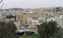
Ramallah is a Palestinian city in the central West Bank, that serves as the de facto administrative capital of the State of Palestine. It is situated on the Judaean Mountains, 10 km north of Jerusalem, at an average elevation of 872 meters (2,861 ft) above sea level, adjacent to al-Bireh.

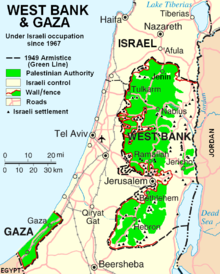
The occupied Palestinian territories, also referred to as the Occupied Palestinian Territory and the Palestinian territories, consist of the West Bank and the Gaza Strip—two regions of the former British Mandate for Palestine that have been occupied by Israel since the Six-Day War of 1967. These territories make up the State of Palestine, which was self-declared by the Palestine Liberation Organization in 1988 and is recognized by 146 out of 193 UN member states.
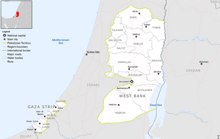
Palestine, officially the State of Palestine, is a country in the southern Levant region of West Asia recognized by 146 out of 193 UN member states. It encompasses the Israeli-occupied West Bank, including East Jerusalem, and the Gaza Strip, collectively known as the occupied Palestinian territories, within the broader geographic and historical Palestine region. Palestine shares most of its borders with Israel, and it borders Jordan to the east and Egypt to the southwest. It has a total land area of 6,020 square kilometres (2,320 sq mi) while its population exceeds five million people. Its proclaimed capital is Jerusalem, while Ramallah serves as its administrative center. Gaza City was its largest city prior to evacuations in 2023.
Beit Hanoun or Beit Hanun is a Palestinian city on the northeast edge of the Gaza Strip. According to the Palestinian Central Bureau of Statistics, the town had a population of 52,237 in 2017. As a result of the ongoing Israel-Hamas war, Beit Hanoun has been militarily contested between the Hamas administration and Israel. Furthermore, the town has been entirely depopulated, and virtually all its structures have either been destroyed or rendered unusable due to extreme damage. The remains of Beit Hanoun are located by the Nahal-Hanun stream, 6 kilometers (3.7 mi) away from the Israeli town of Sderot.
Municipal elections were held between December 2004 and December 2005, to elect members of local councils in the Palestinian Territories. The elections were approved by President Yasser Arafat of the Palestinian National Authority (PNA), before his death on 11 November 2004. They were administered by the Higher Committee for Local Elections (HCLE), a body established under the authority of the Ministry for Local Government, an institution of the Palestinian National Authority.
Salfit is a Palestinian city in the central West Bank, and the capital of the Salfit Governorate of the State of Palestine. Salfit is located at an altitude of 570 meters (1,870 ft), adjacent to the Israeli settlement of Ariel. According to the Palestinian Central Bureau of Statistics (PCBS), Salfit had a population of 10,911 in 2017. Since the 1995 Interim Agreement on the West Bank and the Gaza Strip, Salfit, located in Area A, has been administered by the Palestinian National Authority, while continuing under Israeli military occupation.

Highway 60 or is a south–north intercity road in Israel and the Palestinian West Bank that stretches from Beersheba to Nazareth.

Dura is a Palestinian city located eleven kilometers southwest of Hebron, in the southern West Bank, in the Hebron Governorate of the State of Palestine. According to the Palestinian Central Bureau of Statistics, the town had a population of 39,336 in 2017. The current mayor is Ahmad Salhoub.
The following outline is provided as an overview of and topical guide to the State of Palestine:
Bani Zeid is a Palestinian town in the Ramallah and al-Bireh Governorate of Palestine, in the north-central West Bank, located 27 kilometers (17 mi) northwest of Ramallah, about 45 kilometers northwest of Jerusalem and about 6 kilometers (3.7 mi) southwest of Salfit. A town of over 6,000 inhabitants, Bani Zeid was founded when the villages of Deir Ghassaneh and Beit Rima merged to form a municipality in 1966 during the Jordanian rule.
Qatanna is a Palestinian town in the central West Bank part of the Jerusalem Governorate, located 12 km. northwest of Jerusalem. According to the Palestinian Central Bureau of Statistics, the town had a population of 6,981 inhabitants in 2017. Primary health care for the town is level 2.

Beit Sira is a Palestinian village in the central West Bank, located 22 kilometers west of Ramallah and is a part of the Ramallah and al-Bireh Governorate. The village is situated along the Green Line. During the 1948 Arab-Israeli War, around 4,000 dunams of its land became a part of the "No-Man's Land" strip between the north-central West Bank and Israel. Currently Beit Sira's jurisdiction is 3,120 dunams, of which 441 dunams are built-up areas and the remainder is open spaces for future construction or agricultural land.
Sa'ir is a Palestinian town in the Hebron Governorate of the State of Palestine, in the southern West Bank, located 8 kilometers (5.0 mi) northeast of Hebron. Nearby localities include Beit Fajjar and al-Arroub to the north, Beit Ummar to the northwest, Halhul to the west and Beit Einun and ash-Shuyukh to the south. The Dead Sea is just east of Sa'ir's municipal borders. In the 2017 census Palestinian Central Bureau of Statistics, the town had a population of 20,722.
The water resources of Palestine are de facto fully controlled by Israel, and the division of groundwater is subject to provisions in the Oslo II Accord.

Tourism in the Palestinian territories is tourism in East Jerusalem, the West Bank, and the Gaza Strip. In 2010, 4.6 million people visited the Palestinian territories, compared to 2.6 million in 2009. Of that number, 2.2 million were foreign tourists while 2.7 million were domestic. In the last quarter of 2012 over 150,000 guests stayed in West Bank hotels; 40% were European and 9% were from the United States and Canada. Major travel guides write that "the West Bank is not the easiest place in which to travel but the effort is richly rewarded."
The 2011–2012 Palestinian protests were a series of protests in the Palestinian National Authority and the Hamas-ruled Gaza Strip, staged by various Palestinian groups as part of the wider Arab Spring. The protests were aimed to protest against the Palestinian government, as well as supporting the popular uprisings in Tunisia, Egypt and Syria. The first phase of protests took place during 2011 and the second phase in 2012.

Palestine produces no oil or natural gas and is predominantly dependent on the Israel Electric Corporation (IEC) for electricity. According to UNCTAD, the Palestinian Territory "lies above sizeable reservoirs of oil and natural gas wealth" but "occupation continues to prevent Palestinians from developing their energy fields so as to exploit and benefit from such assets." In 2012, electricity available in West Bank and Gaza was 5,370 GW-hour, while the annual per capita consumption of electricity was 950 kWh. National sources only produce 445 GWh of electricity, supplying less than 10% of demand. The only domestic source of energy is the disputed Gaza Marine gas field, which has not yet been developed. Palestinian energy demand increased rapidly, increasing by 6.4% annually between 1999 and 2005. Future consumption of electricity is expected to reach 8,400 GWh by 2020 on the expectation that consumption will increase by 6% annually.
The Palestinian cabinet, headed by Prime Minister Rami Hamdallah, announced on 23 June 2016 a decision to hold municipal elections on 8 October 2016. The elections were suspended by the Palestinian Court in early September and in January 2017 they were set to 13 May 2017. They were expected to be the first elections in all of the Palestinian territories since Hamas' takeover of the Gaza Strip in 2007, as Hamas agreed to participate in the local elections and allow them to be held in the Gaza Strip but disagreements between Hamas and Fatah led to Hamas boycotting stating it will participate only after "ending disagreements, achieving reconciliation, and uniting Palestinian institutions, including at the political, judicial, and security levels". The elections were later slated to be held in West Bank in May 2017 and were postponed in Gaza Strip.
Events in the year 2020 in Palestine.