The United Nations Educational, Scientific and Cultural Organization (UNESCO) World Heritage Sites are places of importance to cultural or natural heritage as described in the UNESCO World Heritage Convention, established in 1972. [1] The convention established that cultural heritage consists of monuments (such as architectural works, monumental sculptures, or inscriptions), groups of buildings, and sites (including archaeological sites). Meanwhile, natural heritage consists of physical and biological formations, geological and physiographical formations (including habitats of threatened flora and fauna), and natural sites with scientific, conservation, or aesthetic merits. [2]
The Republic of Indonesia ratified the convention on 6 June 1989, making its historical sites eligible for inclusion on the list. [3] As of 2023 [update] , there are ten World Heritage Sites in Indonesia, six of which are cultural and four are natural. This means Indonesia possesses the highest number of sites in Southeast Asia. [4] The first four sites to be inscribed to the list were the Borobudur Temple Compounds, the Prambanan Temple Compounds, Ujung Kulon National Park, and Komodo National Park in 1991. The most recent addition to the list was the Cosmological Axis of Yogyakarta and its Historic Landmarks in 2023. In 2011, the Tropical Rainforest Heritage of Sumatra was inscribed to the list of World Heritage in Danger, due to threats posed by poaching, illegal logging, agricultural encroachment, and plans to build roads through the site. [5] In addition, the government of Indonesia has nominated 18 sites on the tentative list, [3] meaning that they intend to consider them for World Heritage Sites nomination in the future. [6]
UNESCO lists sites under ten criteria; each entry must meet at least one of the criteria. Criteria i through vi are cultural, and vii through x are natural. [7]
† | Indicates sites in danger |
Site | Image | Location (province) | UNESCO data | Year listed | Description |
---|---|---|---|---|---|
Borobudur Temple Compounds | Magelang Regency, Central Java | 592; Cultural: (i), (ii), (vi) | 1991 | Originating from the 8th and 9th centuries, Borobudur's temples is made of three levels: a squared pyramidal base, a cone trunk with three round platforms, and topped by a stupa, making up 2,500 square metres (27,000 square feet). The round platforms are filed with 72 ornamental stupas with a statue of the Buddha. The temple was restored by UNESCO in the 1970s. [8] | |
Cosmological Axis of Yogyakarta and its Historic Landmarks | Special Region of Yogyakarta | 1671; Cultural: (ii), (iii) | 2023 | This centre of the province's sultanate and cultural events opened in the 18th century by Hamengkubuwono I. With respect to Javanese beliefs about the cosmos and cycle of life, the 6-kilometre (3.7 mi) axis connects Mount Merapi (north) and the Indian Ocean (south), centered by the palace (pictured) and other monuments within the axis, which is linked via traditional rituals. [9] This site was previously in the tentative list as the Historical City Centre of Yogyakarta in 2017, under criteria i, ii, and vi. [10] | |
Cultural Landscape of Bali Province: the Subak System as a Manifestation of the Tri Hita Karana Philosophy | Bali | 1194rev; Cultural: (iii), (v), (vi) | 2012 | This area consists of five rice terraces and 19,500 hectares (48,000 acres) water temples managed by the irrigation system of subak, dating back to the ninth century. It was inspired by Tri Hita Karana, an Indian philosophy that connects heaven, humanity, and nature. Subak's "democratic and egalitarian farming practices" helps rice growers in accommodating Bali's dense population. The largest and most notable water temple in Bali is the Pura Taman Ayun, established in the 18th century. [11] The Jatiwulih rice terraces is pictured. | |
Komodo National Park | West Manggarai Regency, East Nusa Tenggara | 609; Natural: (vii), (x) | 1991 | The Lesser Sunda Islands are inhabited around 5,700 giant lizards, named Komodo dragons due to its features and aggression. Unique to the islands, they are demanded by scientists studying the theory of evolution. The area consists of savannah hillsides and various spiky flora, as well as sandy shores and waters with coral reefs underneath. [12] The picture here is taken in Flores. | |
Lorentz National Park | Papua | 955; Natural: (viii), (ix), (x) | 1999 | Spanning 2,350,000 hectares (5,800,000 acres), Lorentz is the largest World Heritage Site in Southeast Asia and the only one globally with a transect between snowy and tropical marine areas, including lowland wetlands. Linking two plate tectonics, it comprises mountains and glaciers. Apart from being the location of fossils proving evolution in New Guinea, it is the most biodiverse area in the region. [13] The Jayawijaya Mountains are pictured. | |
Prambanan Temple Compounds | Central Java and Special Region of Yogyakarta | 642; Cultural: (i), (iv) | 1991 | Above Prambanan's squared foundation are three temples with reliefs based on the ancient epic Ramayana, dedicated to the three deities in Hinduism: Shiva, Vishnu and Brahma. There are also three temples dedicated to their servant animals. Built in the 10th century, it is the largest temple compound dedicated to Shiva in Indonesia. [14] | |
Ombilin Coal Mining Heritage of Sawahlunto | West Sumatra | 1610; Cultural: (ii),(iv) | 2019 | The Dutch East Indies colonial government sought for high-quality coal in Sawahlunto, West Sumatra, and made this mine for accessibility, constructed from the late 19th to early 20th century. With workers comprising locals and convicts, the system accommodates the linear process of extraction, processing, transport, shipment of the coal. This heritage site includes the mining area, the Port of Teluk Bayur (used to store the coal), the railway connecting the two, and the company town. [15] Pictured is a mining activity in Ombilin, dated 1971. | |
Sangiran Early Man Site | Sragen Regency, Central Java | 593; Cultural: (iii), (vi) | 1996 | This site was where the first hominid fossil was discovered during excavations from 1936 to 1941. This propelled the discoveries of half of the known hominid fossils: 50 Meganthropus palaeojavanicus and Homo erectus (French replica pictured). First inhabited one and a half million years prior to inclusion by UNESCO, Sangiran is a key area in studying the human evolution. [16] | |
Tropical Rainforest Heritage of Sumatra † | Aceh, Jambi, and Lampung | 1167; Natural: (vii), (ix), (x) | 2004 | Comprising three national parks—Gunung Leuser National Park, Kerinci Seblat National Park and Bukit Barisan Selatan National Park—this site ranges 2,500,000 hectares (6,200,000 acres) and houses over 10,000 flora, including 17 endemic species. There are also over 200 mammals, including 22 Asian species unique in this Indonesian region, with 15 exclusively living here, like the Sumatran orangutan. There are 580 birds (465 sedentary, 21 endemic). This site is crucial in preserving the diverse Sumatra biota, and biogeographically researching the evolution of the island. In 2011, it is considered endangered due to poaching, illegal logging, agricultural encroachment, and road building plans. [17] [18] | |
Ujung Kulon National Park | Banten and Lampung | 608; Natural: (vii), (x) | 1991 | Located in the southwestern end of Java, this site encompasses the Ujung Kulon peninsula, and the caldera Krakatoa. Crucial in studying inland volcanoes, it has among the largest remaining Javanese lowland rainforests and it is home to multiple species, with the Javan rhinoceros as the one alarmingly threatened. [19] The Cidaon Savanna is pictured. | |
In addition to sites inscribed on the World Heritage List, member states can maintain a list of tentative sites that they may consider for nomination. Nominations for the World Heritage List are only accepted if the site was previously listed on the tentative list. [20]
Site | Image | Location (province) | UNESCO data | Year listed | Description |
---|---|---|---|---|---|
Bawomataluo Site | South Nias Regency, Nias, North Sumatra | 5463; Cultural: (i), (iv), (vi) | 2009 | Located in the Teluk Dalam province, this 18th-century settlement, designed by the former King Laowo, encompasses 5 hectares (12 acres) and, despite its closeness to the sea, is safe from tsunami due to it being 270 metres (890 ft) above sea level. There are two rows of houses 4 metres (13 ft) apart, with a ritualistic stone monolith in the middle. The complex comprises around 500 houses (one pictured) with a population of 7,000, who are heirs of the Laowos' fourth generation. [21] | |
Betung Kerihun National Park (Transborder Rainforest Heritage of Borneo) | West Kalimantan | 1871; Natural: (viii), (ix), (x) | 2004 | BKNP is located at the headwaters of the Kapuas River and makes up 2.76% of the Kapuas Hulu Regency. With high rainfall, 179 peaks, and hundreds of rivers, the 80,000 hectares (200,000 acres) site borders the Lanjak Entimau Wildlife Sanctuary (LEWS) in Sarawak, Malaysia, establishing the two as an orangutan Biodiversity Conservation Area. There are over 1,254 plant species and 652 fauna, 67 and 81 of them (respectively) were listed in the 2000 IUCN Red List of Threatened Species, including Pongo pygmaeus (pictured), one of the two Indonesian orangutan species. BKNP is also utilized by the indigenous Dayak people for hunting and shifting cultivation. [22] | |
Bunaken National Park | Manado, North Sulawesi | 2002; Natural: (vii), (viii), (ix), (x) | 2005 | Formerly a tiny, 5–24 million-year-old continent with volcanic activity 1.5 to 5 million years prior to inscription which created its characteristic tuff, this park is named after the Bunaken Island, the highest island in the area with elevation at over 600 m above sea level and various fossil coral. This site also includes the inactive volcano Manado Tua, an unnamed flat plateau, the dome-shaped Nain Island, the slightly flat Mantehage Island which is seemingly sinking, the coral sand island Siladen, and the areas Arakan-Wawontulap and Molas-Wori located on the Sulawesi mainland. Bunaken Island houses various mangrove forest flats. [23] | |
Derawan Islands | Berau Regency, East Kalimantan | 2007; Natural: (x) | 2005 | The water in this island chain is a coalescence of the Berau River and the Celebes Sea, forming a wide river delta that leads to a sea of patch reefs, fringing reefs, and atolls. It spans 100 miles along the coast of East Kalimantan, and houses an abundance of plants and animals. [24] | |
The Historic and Marine Landscape of the Banda Islands | Central Maluku Regency, Maluku | 6065; Mixed: (iv), (vi), (x) | 2015 | Also known as the Spice Islands due to it used to being the sole location of the nutmeg and mace production during the Dutch, English, and Portuguese era, this chain comprise eleven volcanic islands: Neira, Gunung Api, Banda Besar, Rhun, Ai, Hatta, Syahrir, Karaka, Manukan, Nailaka and Batu Kapal, making up for approximately 8,150 hectares (20,100 acres). [25] | |
Kebun Raya Bogor | Bogor, West Java | 6353; Cultural: (ii), (iv) | 2018 | Also called the Bogor Botanic Gardens (BBG), this is an ex situ conservation area ranging 75.4 hectares (186 acres) and home to over 24 natural science research institutions. It was intended to acclimate foreign plants of high economic potential, before broadening its scope to rare endemic plants. The collection is arranged in blocks and grouped by taxonomy and themes. [26] A group of Pachystachys lutea is pictured. | |
Muara Takus Compound Site | Kampar Regency, Riau | 5464; Cultural: (i), (iv), (vi) | 2009 | This site is divided into two areas by the Kampar Kanan River; there is also another river known by the locals as the Umpamo or Limpamo River. Its headwaters is located in the swamp southeast of Muara Takus, and ends in the Kampar Kanan, with its estuary situated exactly at the northernmost curve of the Kampar Kanan. There was a settlement at the inner and northern side of the Kampar Kanan's riverbend, but all inhabitants were relocated, due to a hydroelectricity plant project, to a place around 1.5 kilometres (0.93 mi) south. [27] The main stupa is pictured. | |
Muarajambi Compound Site | Muaro Jambi Regency, Jambi | 5465; Cultural: (ii), (iii), (iv) | 2009 | Once the centre of Buddhism of the Melayu Kingdom in the 7th–14th centuries, the Muarajambi Compound spans 7.5 kilometres (4.7 mi) of the banks of the Batanghari River, with ancient canals leading to the site. Covering 2,062 hectares (5,100 acres), there are around 82 ruins of ancient brick buildings. There are seven temples: Gumpung (pictured), Tinggi I, Tinggi II, Kembar Batu, Astano, Gedong I, Gedong II, and Kedaton. They were extensively restored, with the remaining ruins surrounded by an endemic plants plantation made by the local Menapo people. Several canals and ponds have been cleared from aquatic plants. [28] | |
The Old Town of Jakarta (Formerly old Batavia) and 4 Outlying Islands (Onrust, Kelor, Cipir and Bidadari) | Jakarta | 6010; Cultural: (ii),(iii),(iv),(v) | 2015 | Located at the mouth of the Ciliwung River, Batavia was established by the Dutch East India Company (VOC) as a trading hub in 1619, then modified in 1650. This site comprises the 1650 town (1.5-by-1-kilometre (0.93 mi × 0.62 mi)), and includes the former Jayakarta area, two 18th-century houses, three warehouses, the old town wall remains, a VOC shipyard, the Luar Batang Mosque, Fatahillah Square, the Jakarta History Museum, Chinatown, Kalibesar Canal, as well as the Onrust, Kelor, Cipir, and Bidadari islands. [29] | |
Prehistoric Cave Sites in Maros-Pangkep | Maros Regency, South Sulawesi | 5467; Natural: (ix) | 2009 | Located at a mountainous area in the Bulusaraung Mountains, the Maros-Pangkep area is tropical with fluctuating humidity. Most of the conservation forest is within the karst area that is part of the Bantimurung-Bulusaraung National Park, covering 43,750 ha. In addition to being the habitat of a variety of endemic fauna, there are hundreds of caves which contain prehistoric rock art, stone tools, and shells of a mollusca; it is also the origin of various traditional dances. [30] | |
Raja Ampat Islands | West Papua | 2003; Natural: (vii), (x) | 2005 | Raja Ampat is an chain of 1,500 islands (Kri Island pictured); the largest ones are Waigeo, Batanta, Salawati and Misool. Covering about 4,600,000 hectares (11,000,000 acres); they are situated on the western border of the Pacific Ocean and at the northeastern border of the Indonesian Throughflow, with most being on the Sahul Shelf. Between the lands and water are various sheltered bays and turbidites with karstic limestone formations. In 2003, Raja Ampat was declared a regency. [31] | |
Sangkulirang – Mangkahilat Karts: Prehistoric rock art area | East Kalimantan | 6009; Cultural: (iii) | 2015 | The Sangkulirang-Mangkalihat Peninsula houses thousands of rock art paintings with red motif, at 35 locations in seven different karstique mountainous places: Merabu, Batu Raya, Batu Gergaji, Batu Nyere, Batu Tutunambo, Batu Pengadan and Batu Tabalar. It has the most rock artworks in Southeast Asia dating back 5,000 years prior to WHS inscription, and has spiritual themes, with common subjects being handprints, rituals, and hunter-gatherers. [32] | |
Semarang Old Town | Semarang, Central Java | 6011; Cultural: (ii),(iv) | 2015 | Semarang was established in the 17th century as an important economic, political and social hub city. A plethora of buildings with various architectural styles like medieval, Baroque, and modern are preserved in its old town area, a visual record of the city's advancement as propelled by the Industrial Revolution. The government deems this area, which includes office buildings, warehouses, stores, banks, and foreign consulates, worth preserving due to the high threats of flooding and land subsidence. [33] | |
Taka Bonerate National Park | Selayar Regency, South Sulawesi | 2005; Natural: (vii), (viii), (ix), (x) | 2005 | With an area of 530,765 ha, the Taka Bonerate National Park includes the third biggest atoll in the world, after Kwajalein in the Marshall Islands and Huvadhu in the Maldives, which encompasses 220,000 hectares (540,000 acres) with coral reefs (pictured) spreading over 500 sq km. Meaning "coral piled up on sand" in Buginese, there are 15 islands, with various tourist recreational tours. [34] | |
Tana Toraja Traditional Settlement | Tana Toraja Regency, South Sulawesi | 5462; Cultural: (iv), (v), (vi) | 2009 | This complex comprises 10 settlements, with facilities like houses (pictured), granaries, burials, ceremonial grounds with menhirs, rice-fields, bamboo forests, and pastures for buffalos and pigs. They occupy about 3.205 sq km with plateaus at 300–2,000 metres (980–6,560 ft) above sea level. The settlements are Pallawa, Bori Parinding, Kande Api, Nanggala, Buntu Pune and Rante Karassik, Ke'te Kesu', Pala' Toke', Londa, Lemo, and Tumakke. Buntu Pune and Rante Karassik was once combined and thus listed so. Only Ke'te Kesu' has all the facilities mentioned. [35] | |
Traditional Settlement at Nagari Sijunjung | Sijunjung Regency, West Sumatra | 6059; Cultural: (iii),(v) | 2015 | This site includes two villages, Jorong Koto Padang and Tanah Bato, as well as two large rivers, Batang Sukam and Batang Kulampi. The villages have 76 Rumah Gadang ('big houses') in total, inhabited by nine Minangkabau clans who run by matriarchy as symbolized in the houses' traditional designs. The site also includes paddy fields, a plantation, graveyards, mosques, madarasas, a market, and a community centre. As per the people's philosophy "natural realm as teacher", each houses has a yard with plants deemed ecologically vital. [36] | |
Trowulan - Former Capital City of Majapahit Kingdom | Mojokerto Regency, East Java | 5466; Cultural: (i), (v) | 2009 | This is the only remaining site of the Hindu-Buddhist antiquity in Indonesia, the capital city of the Majapahit Kingdom, covering 11-by-9-kilometre (6.8 mi × 5.6 mi). It was built on flat terrains below three mountains: Penanggungan, Welirang, and Anjasmara. Trowulan was advantaged for humans due to its flat surface and shallow groundwater. Since 1815, archeologists began excavating the site, uncovering records of daily life there. It was also revealed to have an extensive, symmetrical canal system. [37] One of its candi bentar is pictured. | |
Wakatobi National Park | Buton Regency, Southeast Sulawesi | 2006; Natural: (vii), (viii), (ix), (x) | 2005 | Most waters of Wakatobi originate at a flat surface and then to sea, some of which due to precipices. The deepest seabed is 1,044 metres (3,425 ft) below the surface decorated by sand and coral. The park has 25 coral reef chains, with a circumference of 600 kilometres (370 mi); the total area 1,390,000 hectares (3,400,000 acres). It holds high potential in marine resources and with an "enchanting" seascape. [38] |
Borobudur, also transcribed Barabudur, is a 9th-century Mahayana Buddhist temple in Magelang Regency, near the city of Magelang and the town of Muntilan, in Central Java, Indonesia.
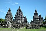
Prambanan is a 9th-century Hindu temple compound in the Special Region of Yogyakarta, in southern Java, Indonesia, dedicated to the Trimūrti, the expression of God as the Creator (Brahma), the Preserver (Vishnu) and the Destroyer (Shiva). The temple compound is located approximately 17 kilometres (11 mi) northeast of the city of Yogyakarta on the boundary between Central Java and Yogyakarta provinces.
Ujung Kulon National Park is a national park at the westernmost tip of Java, located in Sumur District of Pandeglang Regency, part of Banten province in Indonesia. It once included the volcanic island group of Krakatoa in Lampung province, although current maps has suggested the Krakatoa island group as its own protected area, the Pulau Anak Krakatau Marine Nature Reserve.
Tourism in Indonesia is an important component of the Indonesian economy as well as a significant source of its foreign exchange revenues. Indonesia was ranked at 20th in the world tourist Industry in 2017, also ranked as the ninth-fastest growing tourist sector in the world, the third-fastest growing in Asia and fastest-growing in Southeast Asia. In 2018, Dénpasar, Jakarta and Batam are among of 10 cities in the world with fastest growth in tourism, 32.7, 29.2 and 23.3 percent respectively. The tourism sector ranked as the 4th largest among goods and services export sectors.
Yogyakarta is the capital city of the Special Region of Yogyakarta in Indonesia, in the south-central part of the island of Java. As the only Indonesian royal city still ruled by a monarchy, Yogyakarta is regarded as an important centre for classical Javanese fine arts and culture such as ballet, batik textiles, drama, literature, music, poetry, silversmithing, visual arts, and wayang puppetry. Renowned as a centre of Indonesian education, Yogyakarta is home to a large student population and dozens of schools and universities, including Gadjah Mada University, the country's largest institute of higher education and one of its most prestigious.
Sleman Regency is an Indonesian regency on the island of Java. It is located in the north of the Yogyakarta Special Administrative Region, Indonesia, and has an area of 574.82 square kilometres (221.94 sq mi), with a population of 1,093,110 at the 2010 Census and 1,125,804 at the 2020 Census; the official estimate as at mid 2023 was 1,157,292 - comprising 573,760 males and 583,540 females. Its capital is the town of Sleman. The current regent is Kustini Sri Purnomo.
A candi is a Hindu or Buddhist temple in Indonesia, mostly built during the Zaman Hindu-Buddha or "Hindu-Buddhist period" between circa the 4th and 15th centuries.
Trail of Civilizations was the motto of a symposium, initially held in August 2006 in Indonesia under the auspices of the governor of Central Java and the Indonesian Ministry of Culture and Tourism. Climax of the event was a ballet performance in front of the temple of Borobudur.
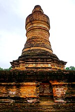
Penataran or Panataran is one of the largest Hindu temple ruins complexes in East Java, Indonesia. It is located in Penataran, Blitar Regency, roughly 12 km northeast of Blitar, with the closest airport being farther away at Malang. Believed to have been constructed between the 12th century to the 15th century, the temple played a significant role in the Majapahit Kingdom, especially under King Hayam Wuruk. He considered it his favorite sanctuary. Penataran dates from the Kediri era.
Prambanan Temple Compounds is the World Heritage designation of a group of Hindu temple compounds that lie on the border between Yogyakarta and Central Java, Indonesia. It comprises Prambanan, Lumbung, Bubrah and Sewu temple compounds, all are located within Prambanan Archaeological Park.
Borobudur Temple Compounds is the World Heritage designation of the area of three Buddhist temples in Central Java, Indonesia. It comprises Borobudur, Mendut, and Pawon. The temples were built during the Shailendra dynasty around the 8th and 9th centuries CE and fall on a straight line.
Protected areas of Indonesia comprise both terrestrial and marine environments in any of the six IUCN Protected Area categories. There are over 500 protected areas in Indonesia, of which 54 National Parks cover 16.4 million ha, and another 527 nature and game reserves cover a further 28.3 million ha. The total protected land area represents over 15% of Indonesia's landmass. Marine Protected Areas comprise over 15.7 million ha representing ca. 5% of territorial waters.
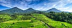
Kewu Plain, also known as Prambanan Plain or Opak River Valley, is a fertile volcanic plain that lies between the Merapi-Merbabu complex in the north, the Bantul lowlands and Sewu karst limestone range in the south, Bengawan Solo river valley in the east, the Progo River in the west, and Kedu Plain on the northwest. It is located within the Yogyakarta Special Region, Sleman Regency, Klaten Regency, and Solo City, Indonesia.
Cultural properties of Indonesia are those items defined by Indonesian law as of "important value for history, science, and culture", and include both man-made artefacts and natural objects. The cultural properties number more than 8,000 and include ancient Hindu and Buddhist temples, mosques, historic colonial buildings, forts, art galleries, national parks and beaches. A number of the sites are World Heritage Sites.
Geoheritage is the geological aspect of natural and cultural heritage. A geosite is a particular geological heritage asset. It is a heritage category comparable to other forms of natural heritage, such as biodiversity.
The archaeology of Indonesia is the study of the archaeology of the archipelagic realm that today forms the nation of Indonesia, stretching from prehistory through almost two millennia of documented history. The ancient Indonesian archipelago was a geographical maritime bridge between the political and cultural centers of Ancient India and Imperial China, and is notable as a part of ancient Maritime Silk Road.