In archaeology, cave paintings are a type of parietal art, found on the wall or ceilings of caves. The term usually implies prehistoric origin. These paintings were often created by Homo sapiens, but also Denisovans and Neanderthals; other species in the same Homo genus. Discussion around prehistoric art is important in understanding the history of the Homo sapiens species and how Homo sapiens have come to have unique abstract thoughts. Some point to these prehistoric paintings as possible examples of creativity, spirituality, and sentimental thinking in prehistoric humans.

East Kalimantan is a province of Indonesia. Its territory comprises the eastern portion of Kalimantan. It had a population of about 3.03 million at the 2010 census, 3.42 million at the 2015 census, and 3.766 million at the 2020 census; the official estimate as at mid 2023 was 4,030,488. Its capital is the city of Samarinda.

Phong Nha-Kẻ Bàng is a national park and UNESCO World Heritage Site in the Bố Trạch and Minh Hóa districts of central Quảng Bình Province in the North Central Coast region of Vietnam, about 500 km south of Hanoi. The park borders the Hin Namno National Park in Khammouane Province, Laos to the west and 42 km east of the East sea from its borderline point. Phong Nha-Kẻ Bàng National Park is in a limestone zone of 2,000 km2 in Vietnamese territory and borders another limestone zone of 2,000 km2 of Hin Namno in Laotian territory. The core zone of this national park covers 857.54 km2 and a buffer zone of 1,954 km2.

Sanming, also known as Minzhong, is a prefecture-level city in western Fujian province, China. It borders Nanping City to the north, Fuzhou City to the east, Quanzhou City to the southeast, Longyan City to the south and the province of Jiangxi to the west. Sanming lies between Wuyi and Daiyun mountains.

The Marble Arch Caves are a series of natural limestone caves located near the village of Florencecourt in County Fermanagh, Northern Ireland. The caves are named after the nearby Marble Arch, a natural limestone arch at the upstream end of Cladagh Glen under which the Cladagh River flows. The caves are formed from three rivers draining off the northern slopes of Cuilcagh mountain, which combine underground to form the Cladagh. On the surface, the river emerges from the largest karst resurgence in Ireland, and one of the largest in the United Kingdom. At 11.5 kilometres (7.1 mi) the Marble Arch Caves form the longest known cave system in Northern Ireland, and the karst is considered to be among the finest in the British Isles.
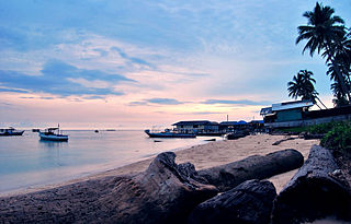
The Derawan Islands are in the province of East Kalimantan in Indonesia. They consist of 31 islands, most well known among these are the islands of Derawan, Kakaban, Maratua, and Sangalaki. There are also numerous submerged reefs and islets. They are located in the Sulawesi Sea, on the coastal shelf of East Kalimantan. The islands are part of the Berau Regency.

The Stone Forest or Shilin is a notable set of limestone formations about 500 km2 located in Shilin Yi Autonomous County, Yunnan Province, People's Republic of China, near Shilin approximately 90 km (56 mi) from the provincial capital Kunming.
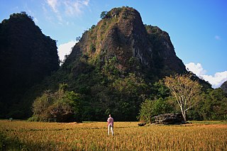
Bantimurung-Bulusaraung National Park is a national park in South Sulawesi in Indonesia. The park contains the Rammang-Rammang karst area, the second largest karst area known in the world after the one in South-Eastern China.
Gunung Sewu is the name for the karst region of southern central Java that lies to the south east of Yogyakarta, south of Surakarta, and is considered a very dry and poor socio-economical region in Java. It has poor rainfall compared to the volcanic mountain areas to the north and east. Administratively most of the region is part of Gunung Kidul Regency, within the Yogyakarta province besides Wonogiri Regency and Pacitan Regency. In 1993, the world speleologs proposed Sewu Mountains Karst Area as a world heritage. And on December 6, 2004 Sewu Mountains and South Gombong have been announced as eco-karst.

Sangkulirang is a district of East Kutai Regency, East Kalimantan, Indonesia. The district lies in the northern part of the Makassar Strait and at the southern part of the Mangkalihat Peninsula. Sangkulirang is situated in the delta of the Karangan river, which forms the Sangkulirang bay on the east coast of Borneo. Most of the district is vegetated with mangrove forest and has some notable karst areas with steep limestone cliffs. The district's seat is located at Benua Baru Ilir.

The caves in the Maros-Pangkep karst are situated in South Sulawesi, Indonesia, and contain paintings from the Paleolithic considered to be the earliest figurative art in the world, dated to at least 43,900 years ago.

Bashkiriya National Park covers a large contiguous forest on the southern end of the Ural Mountains. The park is an important buffer between the industrialized flatlands to the west, and the mountainous and sparsely populated Shulgan-Tash nature reserve and Altyn-Solok entomological reserve to the east and north. Bashkirya National Park lies between the Nugush River, and the southern bend of the Belaya River. The park features deep river valley cuts in a karst topography. It is known for a natural bridge across the river Kuperlya. The park is situated across three districts of the Republic of Bashkortostan.

It is quite difficult to define Indonesian art, since the country is immensely diverse. The sprawling archipelago nation consists of 17,000 islands. Around 922 of those permanently inhabited, by over 1,300 ethnic groups, which speak more than 700 living languages.

Dong Van Karst Plateau Geopark is a geopark in northern Vietnam. It shares border with China in the north. It is a member of the UNESCO Global Geoparks Network and Asia Pacific Geoparks Network, officially since Oct 3, 2010.
Gunung Sewu Geopark or Sewu Mountains is a series of mountains stretching along the southern coast of Gunung Kidul Regency and Wonogiri Regency of Central Java, to Pacitan Regency of East Java in the island of Java, Indonesia. This is a national Geopark, which is also a member of Global Geopark Network (GGN), recognized by UNESCO in 2015.
The Lebbo' people are part of the indigenous Dayak people of East Kalimantan and North Kalimantan, Indonesia.

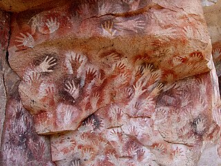
Lubang Jeriji Saleh is a limestone cave complex in Indonesia in the Sangkulirang-Mangkalihat Karst, located in the remote jungle of Bengalon district in East Kutai, East Kalimantan province on Borneo island. In a 2018 publication, a team of researchers announced to have found the then-oldest known work of figurative art in the world among the cave paintings, at 40,000 years old. However, the same team has since found and dated an elaborate therianthrope rock art panel in the Leang Bulu' Sipong 4 cave in Sulawesi's Maros-Pangkep karst to around 44,000 years ago.
Cape Mangkalihat, also known as Cape Sangkulirang, is a cape in eastern Borneo. It is located in the Indonesian province of East Kalimantan, in the regencies of Berau and East Kutai.
