The following article shows a list of caves in Austria . The list also includes ice caves and tourist former salt caves (Salzwelten). [1]
The following article shows a list of caves in Austria . The list also includes ice caves and tourist former salt caves (Salzwelten). [1]
The main concentration of Austrian caves (German: Höhle) is in the Northern Limestone Alps, a mountain range of the Eastern Alps. Many of them are located in the geographical region of Salzkammergut and in the Totes Gebirge.
The caves are listed by alphabetical order and there are shown the main tourist caves and other notable (ex.: archaeological or paleontological) underground voids. In the "length" section is shown, between parentheses, the cave's trail as a show cave (SC).

The Grossglockner, or just Glockner, is, at 3,798 metres above the Adriatic (12,461 ft), the highest mountain in Austria and the highest mountain in the Alps east of the Brenner Pass. It is part of the larger Glockner Group of the Hohe Tauern range, situated along the main ridge of the Central Eastern Alps and the Alpine divide. The Pasterze, Austria's most extended glacier, lies on the Grossglockner's eastern slope.

Dan yr Ogof, at the National Showcaves Centre for Wales, is a 17-kilometre (11 mi) long cave system in south Wales, about 5 miles (8 km) north of Ystradgynlais and 15 miles (24 km) southwest of Brecon, in the Brecon Beacons National Park. It is the main feature of a show cave complex, which is claimed to be the largest in the United Kingdom and is a tourist attraction in Wales. The first section of the cave system is open to the public, but the extensive cave system beyond is scheduled as a national nature reserve and is open only to bona fide cavers.

Lillafüred (Miskolc-Lillafüred) is a town in Borsod-Abaúj-Zemplén county, Hungary. Officially, it is a part of Miskolc, though it is almost 12 kilometres away from the city, in the Bükk Mountains. Lillafüred is a tourist resort.

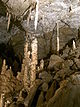
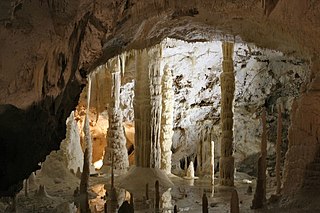
The Eisriesenwelt is a natural limestone and ice cave located in Werfen, Austria, about 40 km south of Salzburg. The cave is inside the Hochkogel mountain in the Tennengebirge section of the Alps. It is the largest ice cave in the world, extending more than 42 km and visited by about 200,000 tourists every year.

A show cave—also called tourist cave, public cave, and, in the United States, commercial cave—is a cave which has been made accessible to the public for guided visits.

Hoher Dachstein is a strongly karstic mountain in central Austria and the second-highest mountain in the Northern Limestone Alps. It is situated at the border of Upper Austria and Styria, and is the highest point in each of those states. Parts of the massif also lie in the state of Salzburg, leading to the mountain being referred to as the Drei-Länder-Berg.

The Jeita Grotto is a system of two separate, but interconnected, karstic limestone caves spanning an overall length of nearly 9 kilometres (5.6 mi). The caves are situated in the Nahr al-Kalb river valley within the locality of Jeita, 18 kilometres (11 mi) north of the Lebanese capital Beirut. Though inhabited in prehistoric times, the lower cave was not rediscovered until 1836 by Reverend William Thomson; it can only be visited by boat since it channels an underground river that provides fresh drinking water to more than a million Lebanese.

The Marble Arch Caves are a series of natural limestone caves located near the village of Florencecourt in County Fermanagh, Northern Ireland. The caves are named after the nearby Marble Arch, a natural limestone arch at the upstream end of Cladagh Glen under which the Cladagh River flows. The caves are formed from three rivers draining off the northern slopes of Cuilcagh mountain, which combine underground to form the Cladagh. On the surface, the river emerges from the largest karst resurgence in Ireland, and one of the largest in the United Kingdom. At 11.5 kilometres (7.1 mi) the Marble Arch Caves form the longest known cave system in Northern Ireland, and the karst is considered to be among the finest in the British Isles.

Moaning Caverns is a solutional cave located in the Calaveras County, California, near Vallecito, California in the heart of the state's Gold Country. It is developed in marble of the Calaveras Formation. It was discovered in modern times by gold miners in 1851, but it has long been known as an interesting geological feature by prehistoric peoples. It gets its name from the moaning sound that echoed out of the cave luring people to the entrance, however expansion of the opening to allow access for the public disrupted the sounds. The portion of the cave developed for tourists consists of a spacious vertical shaft 165 feet tall, which is descended by a combination of stairs and a unique 100-foot-high (30 m) spiral staircase built in the early 1900s. It is open to the public for walking tours and spelunking. Including the off-trail areas, the cave reaches a depth of 410 feet.

Bad Eisenkappel, also known as Eisenkappel, is a municipality located in the Vellach Valley in the Karawanken mountain range with the nearby peaks: Obir, Peca, and Olševa. It is the population center of the market township of Eisenkappel-Vellach of the Völkermarkt district in the State of Carinthia, Austria near the border of Slovenia.

The Hallein Salt Mine, also known as Salzbergwerk Dürrnberg, is an underground salt mine located in the Dürrnberg plateau above Hallein, Austria. The mine has been worked for over 2600 years since the time of the Celtic tribes and earlier. It helped ensure nearby Salzburg would become a powerful trading community. Since World War I, it has served as a mining museum, known for its long wooden slides between levels.
The Frasassi Caves are a karst cave system in the municipality of Genga, Italy, in the province of Ancona, Marche. They are among the most famous show caves in Italy.

The Pertosa Caves, co-officially named Pertosa-Auletta Caves since 2012, are a karst show cave system located in the municipality of Pertosa, in the province of Salerno, Campania, Italy.

The Borgio Verezzi Caves, also named Valdemino, are a karst cave system located in the municipality of Borgio Verezzi, in the province of Savona, Liguria. They are a show cave.

Orlova Chuka is a cave situated in the Danubian Plain, north-eastern Bulgaria. With a total length of 13,437 m, Orlova Chuka is the second longest cave in the country after Duhlata. The cave was discovered in 1941 and opened for tourists in 1957. Orlova Chuka is home to 14 species of bats.

Yagodinska Cave is a cave in the Rhodope Mountains, southern Bulgaria. It is included in the 100 Tourist Sites of Bulgaria and is named after the homonymous village nearby. With a total length of 10,500 m, Yagodinska is the fourth longest cave in the country after Kolkina Dupka, Duhlata and Orlova Chuka and the longest in the Rhodopes. Yagodinska Cave is home to 11 species of bats.

The Lurgrotte karst cave is the largest cave in the Eastern Alps of Styria, Austria. It is located about 16 km (9.9 mi) north of Graz and crosses the Tannenben karst region. The cave has two accessible entrances, one at the village of Semriach and the other at the village of Peggau. At the Semriach entrance, the Lur River sinks into the cave. At the Peggau entrance, the Schmelz River emerges from within the cave, flowing to the west and eventually joining the Mur River.
| Authority control databases: National |
|---|