Related Research Articles

Arunachal Pradesh is a state in northeast India. It was formed from the North-East Frontier Agency (NEFA) region, and India declared it as a state on 20 February 1987. Itanagar is its capital and largest town. It borders the Indian states of Assam and Nagaland to the south. It shares international borders with Bhutan in the west, Myanmar in the east, and a disputed 1,129 km border with China's Tibet Autonomous Region in the north at the McMahon Line. Arunachal Pradesh is claimed in its entirety by China as South Tibet as part of the Tibet Autonomous Region; China occupied some regions of Arunachal Pradesh in 1962 but later withdrew its forces.

Changlang district (Pron:/tʃæŋˈlæŋ/) is located in the Indian state of Arunachal Pradesh, located south of Lohit district and north of Tirap district. Naga people reside here. As of 2011 it is the second most populous district of Arunachal Pradesh, after Papum Pare. It has become one of the major districts in the area owing to the presence of crude oil, coal and mineral resources in addition to tourism and hydropower.

The Nocte people, also known as the Nocte Naga, are a Tibeto-Burmese ethnic group primarily living in Northeast Indian state of Arunachal Pradesh. They number about 111,679, mainly found in the Patkai hills of Tirap district of Arunachal Pradesh, India. Ethnically related to the Konyak Naga, their origins can be traced back to the Hukong Valley in Myanmar, where they migrated from between the 1670 and 1700.
Tirap district (Pron:/tɪˈɹæp/) is a district located in the southeastern part of the state of Arunachal Pradesh in India. It shares a state border with Assam, an international border with Myanmar and a district border with Changlang and Longding.
Tezu is a census town and the headquarters of Lohit district in the Indian state of Arunachal Pradesh. It is the fifth largest town in Arunachal Pradesh and one of its most developed.

Basti district is one of the districts of Uttar Pradesh state, India, and a part of Basti Division. Basti city is the district headquarters.
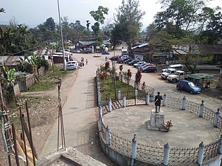
Deomali is a census town in Tirap district in the state of Arunachal Pradesh, India. The town is surrounded by hills, tea gardens, forests and rivers. It serves as the headquarters of both Deomali sub division and Namsang block. It is considered as the education hub of Tirap district and is home to Wangcha Rajkumar Government College, Deomali and renowned educational institution Ramakrishna Mission School, Narottam Nagar. Deomali also has a centre of Krishi Vigyan Kendra. The Coffee Board of India has established a Technical Evaluation Centre in Deomali, one of its such six centres in India. Additionally, Coffee Board of India maintains a 26 acres coffee plantation in Deomali. The town is 250 km from state capital Itanagar, 43 km from district headquarter Khonsa, 30 km from Margherita, 33 km from Naharkatia, 46 km from Tinsukia, 73 km from Dibrugarh and 455 km from Guwahati.

Kingsway Camp is a historic locality situated in the vicinity of Civil Lines and Delhi University in North West Delhi. It commences from the Guru Teg Bahadur Nagar (GTB) intersection, and encompasses residential areas like Hudson Lines and Outram Lines. Neighbouring localities include Dhaka Village, Mukherjee Nagar, and Hakikat Nagar. The foundation of the new capital of British India, New Delhi, was laid at the Coronation Park by King George V in December, 1911, rendering this area historically significant.
Basti is a city, municipal board and administrative headquarters of Basti district in the Indian state of Uttar Pradesh. The district is part of Basti division. It is situated 202 kilometres east of the state capital, Lucknow.

Gandhi Nagar is a residential area in the East Delhi district of Delhi in the Trans-Yamuna area. It is most known for Gandhi Nagar Market, which is Asia's biggest readymade garments/textile market. Gandhi Nagar has many shops and factories.
Arunachal Pradesh is gradually improving with several plans and projects being initiated by both state and central government. Furthermore, there are local NGOs in the state who have undertaken several projects to bring about awareness among the people about the importance of literacy on in far-flung areas. The average literacy rate in Arunachal Pradesh is 82.93% as of the latest report for December 2020. This article provides an outline of the Arunachal Pradesh Education system.
Miles Bronson, was one of the first American Baptist missionaries who worked in the state of Assam in northeastern India.
The Trans-Arunachal Highway (TAH), which includes an existing 1,811 km (1,125 mi) route comprising NH-13 and parts of NH-15, NH-215 and SH-25, is an under-construction 2-lane more than 2,407 km (1,496 mi) long highway passing through 16 districts in Arunachal Pradesh state in India. It runs from LAC in Tawang in northwest to Kanubari in southeast at the tri-junction of Assam-Nagaland-Arunachal Pradesh. It connects at least 16 districts of Arunachal Pradesh.

Chhend Colony is a mixed income group commercial-cum-residential area in the Western Region of Rourkela city, in Sundergarh district. Chhend Colony of Rourkela is situated in Trans Urban area of Rourkela. It is one of the largest colony of India in terms of area.
The first elections to the Arunachal Pradesh Legislative Assembly were held in on 25 February 1978.
East-West Industrial Corridor Highway of Arunachal Pradesh, a 2-lane and 966.78 km long including existing 274.20 km Pasighat-Manmao route, is a proposed highway across the lower foothills of Arunachal Pradesh state in India, from Bhairabkunda in Assam at the tri-junction of Bhutan-Assam-Arunachal Pradesh in the west to the Kanubari tri-junction of Nagaland-Assam-Arunachal Pradesh in the east.
National Highway 28 is a National Highway in India. This highway runs entirely in the state of Uttar Pradesh. It provides main connectivity form India to Nepal.
Place names in India are usually in Indian languages. Other languages include Portuguese, Dutch, English and Arabic.

Pritam Deb is an Indian physicist, nanoscientist and a professor of physics at Tezpur University. He is known for his studies on nanoscience and technology as well as the physics of materials and has published a number of articles; ResearchGate, an online repository of scientific articles has listed 86 of them. Besides, he has also published a book, Kinetics of Heterogeneous Solid State Processes, on nonisothermal kinetics.
References
- ↑ Alubari (2018). Mini Town. Alubari: xxxxxx.