Related Research Articles

The country of Brazil occupies roughly half of South America, bordering the Atlantic Ocean. Brazil covers a total area of 8,514,215 km2 (3,287,357 sq mi) which includes 8,456,510 km2 (3,265,080 sq mi) of land and 55,455 km2 (21,411 sq mi) of water. The highest point in Brazil is Pico da Neblina at 2,994 m (9,823 ft). Brazil is bordered by the countries of Argentina, Bolivia, Colombia, Guyana, Paraguay, Peru, Suriname, Uruguay, Venezuela, and French Guiana.
The Global 200 is the list of ecoregions identified by the World Wide Fund for Nature (WWF), the global conservation organization, as priorities for conservation. According to WWF, an ecoregion is defined as a "relatively large unit of land or water containing a characteristic set of natural communities that share a large majority of their species dynamics, and environmental conditions". For example, based on their levels of endemism, Madagascar gets multiple listings, ancient Lake Baikal gets one, and the North American Great Lakes get none.
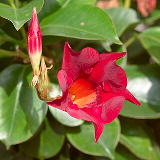
Mandevilla is a genus of tropical and subtropical flowering vines belonging to the family Apocynaceae. It was first described as a genus in 1840. A common name is rocktrumpet.

The ringed antpipit is a species of bird in the family Tyrannidae, the tyrant flycatchers. It is one of two species in the genus Corythopis. It is found in the Amazon Basin of Brazil and the Guianas, and Amazonian Colombia, Ecuador, Peru, and Bolivia; also Guyana, Suriname, French Guiana, and in eastern Venezuela in the Orinoco River drainage.

The wedge-tailed grass finch is a species of bird in the family Thraupidae; it was formerly placed in the Emberizidae. It is found in Argentina, Bolivia, Brazil, Colombia, Costa Rica, Ecuador, French Guiana, Guyana, Panama, Paraguay, Peru, Suriname, Uruguay, and Venezuela.

The spotted tody-flycatcher is a species of bird in the family Tyrannidae, the tyrant flycatchers. It is found in Bolivia, Brazil, Colombia, Ecuador, French Guiana, Guyana, Peru, Suriname, Trinidad and Tobago, and Venezuela, and is mostly a species of the Amazon Basin countries and Guianan countries.

The following outline is provided as an overview of and topical guide to South America.

The Amazon biome contains the Amazon rainforest, an area of tropical rainforest, and other ecoregions that cover most of the Amazon basin and some adjacent areas to the north and east. The biome contains blackwater and whitewater flooded forest, lowland and montane terra firma forest, bamboo and palm forest, savanna, sandy heath and alpine tundra. Some areas of the biome are threatened by deforestation for timber and to make way for pasture or soybean plantations.

Campinarana, also called Rio Negro Campinarana, is a neotropical ecoregion in the Amazon biome of the north west of Brazil and the east of Colombia that contains vegetation adapted to extremely poor soil. It includes savanna, scrub and forest, and contains many endemic species of fauna and flora.

The Japurá–Solimões–Negro moist forests (NT0132) is an ecoregion of tropical moist broad leaf forest in the Amazon biome.

The Purus várzea (NT0156) is an ecoregion of seasonally flooded várzea forest in the central Amazon basin. It is part of the Amazon biome. The ecoregion is home to a vegetation adapted to floods of up to 12 metres (39 ft) that may last for eight months. There is a great variety of fish and birds, but relatively fewer mammals. Ground-dwelling mammals must migrate to higher ground during the flood season. Threats include logging, cattle farming, over-fishing and mercury pollution from gold mining.

The Solimões-Japurá moist forests (NT0163) is an ecoregion in northwest Brazil and eastern Peru and Colombia in the Amazon biome. It has a hot climate with high rainfall throughout the year, and holds one of the most diverse collections of fauna and flora in the world. The ecoregion is relatively intact.

The Uatuma–Trombetas moist forests (NT0173) is an ecoregion in northwest Brazil in the Amazon biome. It covers the Amazon basin north of the Amazon River from close to the Atlantic Ocean to the Rio Negro west of Manaus. The ecoregion is relatively intact, although it has been damaged along the main rivers and around population centers.

The Amazon–Orinoco–Southern Caribbean mangroves (NT1401) is an ecoregion along the coasts of Colombia, Venezuela, Guyana, Suriname, French Guiana and Brazil.

The Guianan mangroves (NT1411) is a coastal ecoregion of southeastern Venezuela, Guyana, Suriname, French Guiana and Brazil. The mangroves provide an important habitat for migrating birds that winter in the area. Large areas are intact, although they are threatened by destruction of the trees for timber and to make way for agriculture, and from upstream agricultural and industrial pollution.
References
- Dinerstein, Eric; David Olson; Douglas J. Graham; et al. (1995). A Conservation Assessment of the Terrestrial Ecoregions of Latin America and the Caribbean. World Bank, Washington DC, .
- Olson, D., Dinerstein, E., Canevari, P., Davidson, I., Castro, G., Morisset, V., Abell, R., and Toledo, E.; eds. (1998). Freshwater Biodiversity of Latin America and the Caribbean: A Conservation Assessment. Biodiversity Support Program, Washington DC, .
- Spalding, Mark D., Helen E. Fox, Gerald R. Allen, Nick Davidson et al. "Marine Ecoregions of the World: A Bioregionalization of Coastal and Shelf Areas". Bioscience Vol. 57 No. 7, July/August 2007, pp. 573–583, .