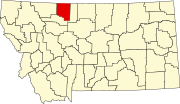
List of lakes in Toole County, Montana

Last updated
Map all coordinates using: OpenStreetMap  ·  Google Maps
Download coordinates as: KML  ·  GPX

There are at least 63 named lakes and reservoirs in Toole County, Montana .

Lake A body of relatively still water, in a basin surrounded by land

A lake is an area filled with water, localized in a basin, that is surrounded by land, apart from any river or other outlet that serves to feed or drain the lake. Lakes lie on land and are not part of the ocean, and therefore are distinct from lagoons, and are also larger and deeper than ponds, though there are no official or scientific definitions. Lakes can be contrasted with rivers or streams, which are usually flowing. Most lakes are fed and drained by rivers and streams.

Reservoir A storage space for fluids

A reservoir is, most commonly, an enlarged natural or artificial lake, pond or impoundment created using a dam or lock to store water.

Toole County, Montana County in the United States

Toole County is a county in the northern portion of the U.S. state of Montana. As of the 2010 United States Census, the population was 5,324. Its county seat is Shelby. The county was established in 1914 from parts of Hill County and Teton County and was named after Joseph Toole, the first and fourth governor of Montana. Its northern boundary is the Canada–United States border south of Alberta.

Contents

Lakes

Davis Lakes is a group of lakes near the northern edge of Duchesne County, Utah, United States.

Perkins Lake

Perkins Lake is an alpine lake in Blaine County, Idaho, United States, located in the Sawtooth Valley in the Sawtooth National Recreation Area. The lake is approximately 21 miles (34 km) south of Stanley and 30 miles (48 km) northwest of Ketchum. Perkins Lake can be accessed from State Highway 75 via Sawtooth National Forest road 205.

Reservoirs

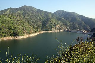
Morris Reservoir

Morris Reservoir is located in the San Gabriel Mountains, within the Angeles National Forest, in Los Angeles County, California.

See also

Notes

  1. "Alkali Lake". Geographic Names Information System . United States Geological Survey.
  2. "Aloe Lake". Geographic Names Information System . United States Geological Survey.
  3. "Benton Trail Lakes". Geographic Names Information System . United States Geological Survey.
  4. "Big Lake". Geographic Names Information System . United States Geological Survey.
  5. "Cameron Lake". Geographic Names Information System . United States Geological Survey.
  6. "Cowboys Lake". Geographic Names Information System . United States Geological Survey.
  7. "Davis Lakes". Geographic Names Information System . United States Geological Survey.
  8. "Fey Lakes". Geographic Names Information System . United States Geological Survey.
  9. "Fitzpatrick Lake". Geographic Names Information System . United States Geological Survey.
  10. "Fitzpatrick Lake". Geographic Names Information System . United States Geological Survey.
  11. "Foxtail Lakes". Geographic Names Information System . United States Geological Survey.
  12. "Frenchman Lake". Geographic Names Information System . United States Geological Survey.
  13. "Goedertz Lake". Geographic Names Information System . United States Geological Survey.
  14. "Hemmings Lake". Geographic Names Information System . United States Geological Survey.
  15. "Jones Lake". Geographic Names Information System . United States Geological Survey.
  16. "Long Lake". Geographic Names Information System . United States Geological Survey.
  17. "Mc Carters Lake". Geographic Names Information System . United States Geological Survey.
  18. "Moltz Lake". Geographic Names Information System . United States Geological Survey.
  19. "Mud Lake". Geographic Names Information System . United States Geological Survey.
  20. "Perkins Lake". Geographic Names Information System . United States Geological Survey.
  21. "Ruby Johnson Lake". Geographic Names Information System . United States Geological Survey.
  22. "Swan Lake". Geographic Names Information System . United States Geological Survey.
  23. "Twin Lakes". Geographic Names Information System . United States Geological Survey.
  24. "Twin Lakes". Geographic Names Information System . United States Geological Survey.
  25. "Verden Lake". Geographic Names Information System . United States Geological Survey.
  26. "Virden Lake". Geographic Names Information System . United States Geological Survey.
  27. "Alkali Lake". Geographic Names Information System . United States Geological Survey.
  28. "Berkholder Reservoir". Geographic Names Information System . United States Geological Survey.
  29. "Big Dam". Geographic Names Information System . United States Geological Survey.
  30. "Big Lake". Geographic Names Information System . United States Geological Survey.
  31. "Cameron Reservoir". Geographic Names Information System . United States Geological Survey.
  32. "Childers Reservoir". Geographic Names Information System . United States Geological Survey.
  33. "Childrers Reservoir". Geographic Names Information System . United States Geological Survey.
  34. "Christian Lake". Geographic Names Information System . United States Geological Survey.
  35. "Christian Reservoir". Geographic Names Information System . United States Geological Survey.
  36. "Cook Reservoir". Geographic Names Information System . United States Geological Survey.
  37. "D Ratzburg Reservoir". Geographic Names Information System . United States Geological Survey.
  38. "Dunkirk Reservoir". Geographic Names Information System . United States Geological Survey.
  39. "Ed McIntyre Reservoir". Geographic Names Information System . United States Geological Survey.
  40. "Gillespie Reservoir". Geographic Names Information System . United States Geological Survey.
  41. "Goeddertz Reservoir". Geographic Names Information System . United States Geological Survey.
  42. "Grassy Lake". Geographic Names Information System . United States Geological Survey.
  43. "Jim Judisch Reservoir". Geographic Names Information System . United States Geological Survey.
  44. "Lake Shel-oole". Geographic Names Information System . United States Geological Survey.
  45. "M Ratzburg Reservoir". Geographic Names Information System . United States Geological Survey.
  46. "MacHale Reservoir". Geographic Names Information System . United States Geological Survey.
  47. "Mary Reservoir". Geographic Names Information System . United States Geological Survey.
  48. "McCarter Lake". Geographic Names Information System . United States Geological Survey.
  49. "McIntyre Reservoir". Geographic Names Information System . United States Geological Survey.
  50. "McLean Reservoir". Geographic Names Information System . United States Geological Survey.
  51. "Melcott Reservoir". Geographic Names Information System . United States Geological Survey.
  52. "Morris Reservoir". Geographic Names Information System . United States Geological Survey.
  53. "Morris Reservoir". Geographic Names Information System . United States Geological Survey.
  54. "Ovens Reservoir". Geographic Names Information System . United States Geological Survey.
  55. "Parsell Lake". Geographic Names Information System . United States Geological Survey.
  56. "Shay Reservoir". Geographic Names Information System . United States Geological Survey.
  57. "Summers Reservoir". Geographic Names Information System . United States Geological Survey.
  58. "Suphellen Reservoir". Geographic Names Information System . United States Geological Survey.
  59. "The Pot Hole". Geographic Names Information System . United States Geological Survey.
  60. "Wanken Reservoir". Geographic Names Information System . United States Geological Survey.
  61. "Wilson Reservoir". Geographic Names Information System . United States Geological Survey.
  62. "Wood Reservoir". Geographic Names Information System . United States Geological Survey.