Related Research Articles

The City of Lake Macquarie is a local government area in the Hunter Region in New South Wales, Australia. It was proclaimed a city from 7 September 1984. The city is situated adjacent to the city of Newcastle and is widely considered as a part of the Greater Newcastle area. The city is approximately 150 km (93 mi) north of Sydney. One of its major tourist attractions is its lake, also named Lake Macquarie.

Hornsby is a suburb on the Upper North Shore of Sydney in the state of New South Wales, Australia, approximately 23 kilometres (14 mi) north-west of the Sydney central business district. It is the administrative centre of the local government area of Hornsby Shire.

Ku-ring-gai Council is a local government area in Northern Sydney, in the state of New South Wales, Australia. The area is named after a fictional Aboriginal Language Group.

Eurobodalla Shire is a local government area located in the South Coast region of New South Wales, Australia. The Shire is located in a largely mountainous coastal region and situated adjacent to the Tasman Sea, the Princes Highway and the Kings Highway.

Epping is a suburb of Sydney, in the Australian state of New South Wales, 18 kilometres north-west of the Sydney central business district in the local government area of the City of Parramatta. Epping is in the Northern Sydney region. The suburb is the most north-eastern area of the City of Parramatta. North Epping is a separate suburb to the north and under a different council, Hornsby Shire.

The Hills Shire is a local government area in the Greater Sydney region of Sydney, New South Wales, Australia. The area is north-west of the Sydney central business district, and encompasses 401 square kilometres (155 sq mi) stretching from the M2 Hills Motorway in the south to Wisemans Ferry on the Hawkesbury River in the north. The Hills Shire had a population of 191,876 as of the 2021 census.

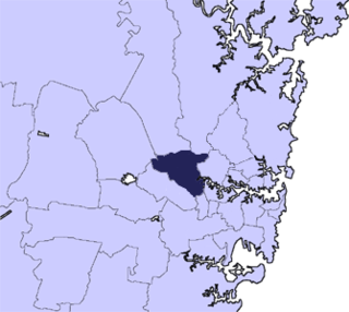
Hornsby Shire is a local government area situated on the Upper North Shore as well as parts of the Hills District, of Sydney in the state of New South Wales, Australia. The shire stretches from the M2 Hills Motorway in the south to the Hawkesbury River town of Wisemans Ferry, some 53 kilometres (33 mi) to the north, making it the largest local government council in the Greater Sydney Metropolitan region by total area. As of the 2016 census the shire had an estimated population of 142,667.

The City of Hawkesbury is a local government area of New South Wales, Australia, located on the northern and north-western fringe of the Greater Sydney area, about 50 kilometres (31 mi) north-west of the Sydney central business district. Hawkesbury City is named after the Hawkesbury River. Major towns in City of Hawkesbury are Windsor, Richmond and Pitt Town.

Blacktown City Council is a local government area in Western Sydney, situated on the Cumberland Plain, approximately 35 kilometres (22 mi) west of the Sydney central business district, in the state of New South Wales, Australia. Established in 1906 as the Blacktown Shire and becoming the Municipality of Blacktown in 1961 before gaining city status in 1979, the City occupies an area of 246.9 square kilometres (95.3 sq mi) and has a population of 410,419, making it the most populous local government area in Sydney.
The City of Parramatta, also known as Parramatta Council, is a local government area located to the west and north-west of Sydney CBD in the Greater Western Sydney region. Parramatta Council is situated between the City of Ryde and Cumberland, where the Cumberland Plain meets the Hornsby Plateau, approximately 25 kilometres (16 mi) west of the Sydney central business district, in New South Wales, Australia. The city occupies an area of 84 square kilometres (32 sq mi) spanning across suburbs in Greater Western Sydney including the Hills District, and a small section of Northern Sydney to the far north east of its area. According to the 2016 census, City of Parramatta had an estimated population of 226,149. The city houses the Parramatta central business district which is one of the key suburban employment destinations for the region of Greater Western Sydney.

Port Macquarie-Hastings Council is a local government area in the Mid North Coast region of New South Wales, Australia.

The Berowra Creek, a watercourse that is part of the Hawkesbury-Nepean catchment, is located to the north of the Sydney central business district in the Hornsby Shire of New South Wales, Australia.

Balranald Shire is a local government area in the Riverina area of western New South Wales, Australia on the Sturt Highway. It is the location of World Heritage listed Mungo National Park. It includes the towns of Balranald and Euston. Other localities in the Shire include Kyalite, Hatfield, Penarie, Clare and Oxley.
Steven Bruce Scott Pringle is a naval officer in the Royal Australian Naval Reserves. He was the member of the New South Wales Legislative Assembly from March 2003 to March 2007, representing the Electorate of Hawkesbury.

Maxwell Stanley Ruddock was a New South Wales politician, Assistant Treasurer and Minister of the Crown in the cabinets of Tom Lewis and Sir Eric Willis. Representing the Liberal Party he was a member of the New South Wales Legislative Assembly for 14 years from 3 March 1962 until his resignation on 25 May 1976.

Local government in the Australian state of Victoria consists of 79 local government areas (LGAs). Also referred to as municipalities, Victorian LGAs are classified as cities (34), shires (38), rural cities (6) and boroughs (1). In general, an urban or suburban LGA is called a city and is governed by a City Council, while a rural LGA covering a larger rural area is usually called a shire and is governed by a Shire Council. Local councils have the same administrative functions and similar political structures, regardless of their classification.

Matthew John Kean is an Australian politician, who was the Treasurer of New South Wales in the second Perrottet ministry of New South Wales between October 2021 and March 2023. He was also the Minister for Energy between April 2019 and March 2023 and was also the Deputy Leader of the Liberal Party from August 2022 till March 2023. He has been Shadow Minister for Health since 2023 and has represented Hornsby for the party in the New South Wales Legislative Assembly since 2011.

The 2021 New South Wales mayoral elections were held on 4 December 2021 to elect mayors or lord mayors to 35 of the 128 local government areas (LGAs) in New South Wales. The elections were held as part of the statewide local elections.
The 2017 New South Wales mayoral elections were held on 9 September 2017 to elect mayors or lord mayors to 13 of the 46 local government areas (LGAs) up for election in New South Wales. The elections were held as part of the statewide local elections.
References
- ↑ List of Presidents or Mayors of Hornsby Shire Archived 23 March 2012 at the Wayback Machine
- ↑ History of Hornsby Shire Archived 23 January 2012 at the Wayback Machine
- ↑ "Hornsby". ABC News.
- ↑ "Hornsby". ABC News.
- ↑ "Hornsby Distribution of Preferences". New South Wales Electoral Commission.