See also
- List of the highest mountains in Germany
- List of the highest mountains in the German states
- List of mountain and hill ranges in Germany
Mountains and hills by state of Germany | ||
|---|---|---|
This List of mountains and hills of the Saarland shows a selection of mountains and hills in the German federal state of the Saarland and is listed by descending height in metres above sea level (NHN).
Name, Height, Location (nearby settlement)
Mountains and hills by state of Germany | ||
|---|---|---|

The Palatinate is a historical region of Germany (Deutschland). In the Middle Ages it was known as the Rhenish Palatinate (Rheinpfalz) and Lower Palatinate (Unterpfalz), which strictly speaking designated only the western part of the Electorate of the Palatinate, as opposed to the Upper Palatinate (Oberpfalz). It occupies roughly the southernmost quarter of the German federal state of Rhineland-Palatinate (Rheinland-Pfalz), covering an area of 2,105 square miles (5,450 km2) with about 1.4 million inhabitants. Its residents are known as Palatines (Pfälzer).

The Nahe is a river in Rhineland-Palatinate and Saarland, Germany, a left tributary to the Rhine. It has also given name to the wine region Nahe situated around it.

Blieskastel is a city in the Saarpfalz (Saar-Palatinate) district, in Saarland, Germany which is divided into villages. It is situated on the river Blies, approximately 10 kilometres southwest of Homburg (Saar), 8 km (5 mi) west of Zweibrücken, and 20 km (12 mi) east of Saarbrücken.

Berglangenbach is an Ortsgemeinde – a municipality belonging to a Verbandsgemeinde, a kind of collective municipality – in the Birkenfeld district in Rhineland-Palatinate, Germany. It belongs to the Verbandsgemeinde of Baumholder, whose seat is in the like-named town.

Abtweiler is an Ortsgemeinde – a municipality belonging to a Verbandsgemeinde, a kind of collective municipality – in the Bad Kreuznach district in Rhineland-Palatinate, Germany. It belongs to the Verbandsgemeinde of Meisenheim, whose seat is in the like-named town.

Achtelsbach is an Ortsgemeinde – a municipality belonging to a Verbandsgemeinde, a kind of collective municipality – in the Birkenfeld district in Rhineland-Palatinate, Germany. It belongs to the Verbandsgemeinde of Birkenfeld, whose seat is in the like-named town.

Rückweiler is an Ortsgemeinde – a municipality belonging to a Verbandsgemeinde, a kind of collective municipality – in the Birkenfeld district in Rhineland-Palatinate, Germany. It belongs to the Verbandsgemeinde of Baumholder, whose seat is in the like-named town.

Herchweiler is an Ortsgemeinde – a municipality belonging to a Verbandsgemeinde, a kind of collective municipality – in the Kusel district in Rhineland-Palatinate, Germany. It belongs to the Verbandsgemeinde of Kusel-Altenglan, whose seat is in Kusel.
Erfweiler is a municipality in Südwestpfalz district, in Rhineland-Palatinate, western Germany. It is a state-recognised resort.

The Soonwald is a forested, low mountain region, up to 657.5 m above sea level (NN), which forms part of the Hunsrück mountains in the German Central Uplands. It lies within the counties of Rhein-Hunsrück-Kreis and Bad Kreuznach in the state of Rhineland-Palatinate.

The Mannheim–Saarbrücken railway is a railway in the German states of Baden-Württemberg, Rhineland-Palatinate and the Saarland that runs through Ludwigshafen am Rhein, Neustadt an der Weinstraße, Kaiserslautern, Homburg and St. Ingbert. It is the most important railway line that runs through the Palatinate. It serves both passenger and freight transport and carries international traffic.
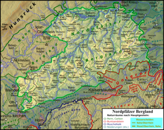
The North Palatine Uplands, sometimes shortened to Palatine Uplands, is a low mountain range and landscape unit in the German state of Rhineland-Palatinate and belongs mainly to the Palatinate region. It is part of the Saar-Nahe Uplands.
The Saar-Nahe Hills or Saar-Nahe Uplands is a major natural region in the German states of Rhineland-Palatinate and the Saarland. The region of hills and mountains covers an area of 4,185 km² running from Saarbrücken, Kaiserslautern and the Palatine Forest in the south to the Hunsrück in the northeast. It contains the catchment area of the Nahe as far as Bad Kreuznach as well as small sections of the Middle Saar in the west.

The Palatine Watershed forms the main drainage divide in the Palatinate between the Upper Rhine and the Middle Rhine, the two successive sections of the river Rhine that flow through the German state of Rhineland-Palatinate.
The Alzey Hills form a region of low, rolling hills, or Hügelland, 275 km² in area and up to 337 m above sea level (NHN), in Rhenish Hesse in the German state of Rhineland-Palatinate. From a natural region perspective they are part of the Upper Rhine Plain and classed as major unit no. 227.

The Westrich Plateau, also Zweibrücken Westrich or Southwest Palatine Plateau, is a landscape in the German state of Rhineland-Palatinate, with small areas also in the Saarland (Saarpfalz-Kreis). Its heart is in the southwest of the Palatinate region and it is part of the historic region of Westrich.

The Schwarzwälder Hochwald, not to be confused with the High Black Forest, is the high south-western part of the Hunsrück in the German states of Saarland and Rhineland-Palatinate. The mountains are up to 816.32 m high.

The Ellerspring, at 657.5 m above sea level (NHN), is the highest point of the Soonwald, a part of the Hunsrück mountains in the German Central Uplands. It is situated near Winterbach in the county of Bad Kreuznach in the state of Rhineland-Palatinate

The Saar-Hunsrück Nature Park was established in 1980 and covers an area of just under 2,000 km² in the German states of Rhineland-Palatinate and the Saarland.
The Dollberge are a small mountain range in the northern Saarland and the adjoining part of the state of Rhineland-Palatinate in Germany. They form a southeastern element of the Schwarzwälder Hochwald, a region in the Hunsrück mountains, and are up to 707.4 m above sea level (NN).