List of mountains and hills of Rhineland-Palatinate

Last updated

View from the Erbeskopf Blick-vom-erbeskopf.jpg
View from the Erbeskopf

This list of mountains and hills in Rhineland-Palatinate shows a selection of high and/or well-known mountains and hills in the German state of Rhineland-Palatinate (in order of height). Although there is no universally agreed definition, this list treats a mountain as an elevation of 2000 feet (612 m) or higher.

Contents

Highest points of the Rhineland-Palatinate regions

The following table shows the highest mountains and hills of the Rhineland-Palatinate regions.

In the "Region" column, extensive or high ranges are shown in bold; whilst landscapes which either have no obvious high point or are lowlands with prominent hills (sometimes island-like) are shown in italics. Clicking on the word "List" (in the "Lists" column), links to further lists of mountains and hills in the particular region or landscape indicated (sometimes outside Rhineland-Palatinate).

The table, which is arranged in order of height, may be sorted by clicking on the symbol at the head of the relevant column.

Erbeskopf
(Schwarzwalder Hochwald, Hunsruck) Blick-vom-erbeskopf.jpg
Erbeskopf
(Schwarzwälder Hochwald, Hunsrück)
Hohe Acht
(High Eifel, Eifel) HoheachtRassberg.jpg
Hohe Acht
(High Eifel, Eifel)
Rosterkopf
(Osburger Hochwald, Hunsruck) Roesterkopf.jpg
Rösterkopf
(Osburger Hochwald, Hunsrück)
Ernstberg
(Volcanic Eifel, Eifel) Erresberg.jpg
Ernstberg
(Volcanic Eifel, Eifel)
Schwarzer Mann
(Schneifel, Eifel) Schwarzermann Schneifel.jpg
Schwarzer Mann
(Schneifel, Eifel)
Donnersberg
(North Palatine Uplands) Donnersberg von Steinbach.jpg
Donnersberg
(North Palatine Uplands)
Kalmit
(Haardt (Palatinate), Palatine Forest) Kalmit.jpg
Kalmit
(Haardt (Palatinate), Palatine Forest)
Aremberg
(Ahr Hills, Eifel) Arembergberg.jpg
Aremberg
(Ahr Hills, Eifel)
Mountain /
Hill
Height
(m)
LandscapeLists of
mountains & hills
County /
Counties
(or fed. state)
Independent
city / town
Erbeskopf 816.32 Hunsrück
(Schwarzwälder Hochwald)
List
List
Bernkastel-Wittlich
An den zwei Steinen 766.2 Idar Forest
Part of the Hunsrück
List
List
Bernkastel-Wittlich,
Birkenfeld
Hohe Acht 746.9 Eifel
( High Eifel )
List
List
Ahrweiler,
Mayen-Koblenz
Rösterkopf 708.1 Osburger Hochwald
Part of the Hunsrück
---
List
Trier-Saarburg
Ernstberg
(Erensberg, Erresberg)
699.8 Vulkan Eifel
Part of the Eifel
List
List
Vulkaneifel
Unnamed peak
(near the Schwarzer Mann)
699.1 Schneifel
Part of the Eifel
List
List
Eifelkreis Bitburg-Prüm
Donnersberg 686.5
[1]
North Palatine Uplands List Donnersberg
Kalmit 672.6 Palatine Forest
(Haardt)
List
List
Neustadt,
Südliche Weinstraße
Fuchskaute 657.3 Westerwald
(High Westerwald)
List
---
Westerwald
Ellerspring 656.8 Soonwald
Part of the Hunsrück
List
List
Bad Kreuznach
Kandrich 638.6 Bingen Forest
Part of the Hunsrück
List
List
Bad Kreuznach
Aremberg 623.8 Ahr Hills
Part of the Eifel
List
List
Ahrweiler
Womrather Höhe 599.1 Lützelsoon
Part of the Hunsrück
List
List
Bad Kreuznach,
Rhein-Hunsrück
namenlose Kuppe477.5 Kondelwald --- Bernkastel-Wittlich
Kewelsberg 441.8 Saargau --- Trier-Saarburg
Asberg 441,0 Rheinwesterwald Volcanic Ridge
Part of the Westerwald
List
List
Neuwied
Lemberg 422.8 Naheland --- Bad Kreuznach
Kappelberg 357.6 Rhenish-Hessian Hills List Alzey-Worms
Auf der Platte 337.0 Alzey Hills List Bad Dürkheim

Mountains

Name, Height in metres above sea level (NN), Location (district/region). Three ??? mean unknown or not yet researched; please add information!

  1. Erbeskopf (816 m), Bernkastel-Wittlich district, Schwarzwälder Hochwald, Hunsrück
  2. An den zwei Steinen (766 m), Bernkastel-Wittlich district, Idar Forest, Hunsrück
  3. Kahlheid (766 m), Bernkastel-Wittlich district, Idar Forest, Hunsrück
  4. Steingerüttelkopf (757 m), Birkenfeld district, Idar Forest, Hunsrück
  5. Sandkopf (756 m), Trier-Saarburg district, Schwarzwälder Hochwald, Hunsrück
  6. Ruppelstein (755 m), Birkenfeld district, Schwarzwälder Hochwald, Hunsrück
  7. Hohe Acht (747 m), Ahrweiler district, High Eifel, Eifel
  8. Idarkopf (746 m), Birkenfeld district, Idar Forest, Hunsrück
  9. Usarkopf (724 m), Birkenfeld district, Idar Forest, Hunsrück
  10. Butterhecker Steinköpfe (723 m), Birkenfeld district, Schwarzwälder Hochwald, Hunsrück
  11. Ringelkopf (712 m), Birkenfeld district, Schwarzwälder Hochwald, Hunsrück
  12. Rösterkopf (708 m), Trier-Saarburg district, Osburger Hochwald, Hunsrück
  13. Friedrichskopf (707 m), Birkenfeld district, Dollberge/Schwarzwälder Hochwald, Hunsrück
  14. Ernstberg (Erresberg) (698.8 m), Vulkaneifel district, High Eifel, Eifel
  15. Schwarzer Mann (697.3 m), Bitburg-Prüm Eifel district, Schneifel, Eifel
  16. Teufelskopf (695 m), Trier-Saarburg district, Irrwald/Schwarzwälder Hochwald, Hunsrück
  17. Schimmelkopf (694.8 m), Merzig-Wadern district, Irrwald/Schwarzwälder Hochwald, Hunsrück
  18. Mückenbornberg (691 m), Trier-Saarburg district, Irrwald/Schwarzwälder Hochwald, Hunsrück
  19. Scharteberg (691 m), Vulkaneifel district, High Eifel, Eifel
  20. Donnersberg (687 m), [1] Donnersbergkreis, North Palatine Uplands
  21. Prümscheid (675 m), Vulkaneifel district, High Eifel, Eifel
  22. Wildenburger Kopf (674 m), Birkenfeld district, Schwarzwälder Hochwald, Hunsrück
  23. Kalmit (673 m), Südliche Weinstraße district, Haardt, Palatine Forest
  24. Hohe Wurzel (669 m), Trier-Saarburg district, Osburg High Forest, Hunsrück
  25. Schöneberg (668 m), Ahrweiler district, Schneifel, Eifel
  26. Wehlenstein (668 m), Birkenfeld district, Schwarzwälder Hochwald, Hunsrück
  27. Sandkopf (665 m), Birkenfeld district, Schwarzwälder Hochwald, Hunsrück
  28. Kesselberg (663 m), Südliche Weinstraße district, Haardt, Palatine Forest
  29. Seimersberg (663 m), Bitburg-Prüm Eifel district, Schneifel, Eifel
  30. Ellerspring (657 m), Bad Kreuznach district, Soonwald, Hunsrück
  31. Fuchskaute (657 m), Westerwald district, High Westerwald, Westerwald
  32. Stegskopf (654.4 m), Altenkirchen district, Westerwald
  33. Salzburger Kopf (654.2 m), Westerwaldkreis, Westerwald
  34. Simmerkopf (653 m), Rhein-Hunsrück district, Soonwald, Hunsrück
  35. Ringkopf (650 m), Birkenfeld district, Schwarzwälder Hochwald, Hunsrück
  36. Opel (649 m), Bad Kreuznach district and Landkreis Rhein-Hunsrück district, Soonwald, Hunsrück
  37. Hochsteinchen (648 m), Rhein-Hunsrück district, Soonwald, Hunsrück
  38. Nerother Kopf (647 m), Vulkaneifel district, High Eifel, Eifel
  39. Mörschieder Burr] (646 m), Birkenfeld district, Schwarzwälder Hochwald, Hunsrück
  40. Prümer Kopf (646 m), Bitburg-Prüm Eifel district, Schneifel, Eifel
  41. Schanzerkopf (643 m), Rhein-Hunsrück district, Soonwald, Hunsrück
  42. Kühlfelder Stein (638 m), ??? district, Westerwald
  43. Esselsberg (637 m), ??? district, High Eifel, Eifel
  44. Kandrich (637 m), Mainz-Bingen district, Bingen Forest, Hunsrück
  45. Katzenkopf (637 m), Rhein-Hunsrück district, Soonwald, Hunsrück
  46. Roßberg (637 m), Südliche Weinstraße district, Haardt, Palatine Forest
  47. Hochberg (636 m), Südliche Weinstraße district, Haardt, Palatine Forest
  48. Ochsenbaumer Höhe (632 m), Rhein-Hunsrück district, Soonwald, Hunsrück
  49. Salzkopf (628 m), Mainz-Bingen district, Bingen Forest, Hunsrück
  50. Aremberg (623.0 m), Ahrweiler district, Ahr Hills, Eifel
  51. Silberich (623 m), Birkenfeld district, Schwarzwälder Hochwald, Hunsrück
  52. Alteburg (621 m), Bad Kreuznach district, Soonwald, Hunsrück
  53. Vorkastell (620 m), ??? district, Dollberge/Schwarzwälder Hochwald, Hunsrück
  54. Hohe Loog (619 m), town of Neustadt an der Weinstraße, Haardt, Palatine Forest
  55. Franzosenkopf (618 m), Mainz-Bingen district, Bingen Forest, Hunsrück
  56. Blättersberg with the Ludwig Tower (617.5 m), Südliche Weinstraße district, Haardt, Palatine Forest
  57. Schafkopf (617 m), Südliche Weinstraße district, Palatine Forest
  58. Höchstberg (616 m), ??? district, Vulkaneifel, Eifel
  59. Auf der Wurst (615 m), ??? district, Schneifel, Eifel
  60. Alsberg (613 m), Westerwald district, Westerwald
  61. Steigerkopf (also: Schänzel) with the Schänzel Tower (613 m), Südliche Weinstraße district, Palatine Forest

Hills

  1. Dreiser Höhe (611 m), ??? district, High Eifel, Eifel
  2. Blattersberg (609 m), Südliche Weinstraße district, Palatine Forest
  3. Eschkopf (609 m), Südwestpfalz district, Palatine Forest
  4. Mosisberg (609 m), Südwestpfalz district, Palatine Forest
  5. Morschenberg (608 m), Südliche Weinstraße district, Haardt, Palatine Forest
  6. Rothsohlberg (607 m), Südliche Weinstraße district, Haardt, Palatine Forest
  7. Steffelnkopf (607 m), ??? district, Schneifel, Eifel
  8. Weißenberg (607 m), Südwestpfalz district, Palatine Forest
  9. Hortenkopf (606 m), Südwestpfalz district, Palatine Forest
  10. Taubenkopf (604 m), town of Neustadt an der Weinstraße, Haardt, Palatine Forest
  11. Heimerich (601 m), ??? district, Westerwald
  12. Teufelsberg (598 m), Südliche Weinstraße district, Haardt, Palatine Forest
  13. Hardtkopf (597 m), Bitburg-Prüm Eifel district, South Eifel, Eifel
  14. Womrather Höhe (597 m), Rhein-Hunsrück district, Lützelsoon, Hunsrück
  15. Hochsimmer (587.9 m), Mayen-Koblenz district, High Eifel
  16. Herzerberg (585 m), Kusel district, North Palatine Uplands
  17. Orensberg (581 m), Südliche Weinstraße district, Haardt, Palatine Forest
  18. Rehberg (576.8 m), Südliche Weinstraße district, Wasgau, Palatine Forest
  19. Stolzberg (572 m), Kusel district, North Palatine Uplands
  20. Schindhübel (571 m), Bad Dürkheim district, Palatine Forest
  21. Drachenfels (570.8 m), Bad Dürkheim district, Palatine Forest
  22. Bloskülb (570 m), Bad Dürkheim district, Palatine Forest
  23. Großer Adelberg (569 m), Südliche Weinstraße district, Palatine Forest
  24. Brogberg (567 m), Bad Dürkheim district, Palatine Forest
  25. Hoher Stoppelkopf (567 m), Bad Dürkheim district, Palatine Forest
  26. Königsberg (567 m), Kusel district, North Palatine Uplands
  27. Almersberg (564 m), Südliche Weinstraße district, Palatine Forest
  28. Potzberg (562 m), Kusel district, North Palatine Uplands
  29. Steinberger Ley] (558 m), ??? district, Vulkaneifel, Eifel
  30. Hohenberg (556 m), Südliche Weinstraße district, Haardt, Palatine Forest
  31. Rockeskyller Kopf (555 m), Vulkan Eifel district, Vulkaneifel
  32. Weinbiet (553 m), town of Neustadt an der Weinstraße, Haardt, Palatine Forest
  33. Koppensteiner Höhe (551 m), Rhein-Hunsrück district, Soonwald, Hunsrück
  34. Hoher List (549 m), Vulkan Eifel district, Vulkaneifel, Eifel
  35. Selberg (546 m), Kusel district, North Palatine Uplands
  36. Montabaurer Höhe (545 m), Westerwald district, Westerwald
  37. Köppel (540 m), Westerwald district, Westerwald
  38. Herrmannsberg (536 m), Kusel district, North Palatine Uplands
  39. Bobenthaler Knopf (534 m), Südwestpfalz district, Palatine Forest
  40. Hohenseelbachskopf (530 m),??? district, Westerwald
  41. Bornberg (Palatinate) (520 m), Kusel district, North Palatine Uplands
  42. Rahnfels (517 m), Bad Dürkheim district, Haardt, Palatine Forest
  43. Eckkopf (516 m), Bad Dürkheim district, Palatine Forest
  44. Großer Eyberg (513 m), Südwestpfalz district, Palatine Forest
  45. Hochthürmerberg (499.8 m), Euskirchen district, Ahr Hills
  46. Stabenberg (496 m), town of Neustadt an der Weinstraße, Haardt, Palatine Forest
  47. Goßberg (Hunsrück) (494 m), Rhein-Hunsrück district
  48. Peterskopf (487 m), Bad Dürkheim district, Haardt, Palatine Forest
  49. Weilerskopf (470 m), Bad Dürkheim district, Haardt, Palatine Forest
  50. Asberg (441 m), Neuwied district, Unkel
  51. Spitzkopf (429 m), Bad Dürkheim district, Palatine Forest
  52. Dernbacher Kopf (427 m), Neuwied district, Dernbach (near Dierdorf)
  53. Meerberg (422 m), Neuwied district, Linz
  54. Lemberg (422 m), Bad Kreuznach district, Naheland
  55. Hochberg (421 m), Südwestpfalz district, Wasgau, Palatine Forest
  56. Heidenberg with the Buchkammerfels (420 m), Südwestpfalz district, Wasgau, Palatine Forest
  57. Minderberg (417 m), Neuwied district, Linz
  58. Heiße Bäumchen (410 m), Bad Ems district, Dachsenhausen
  59. Mainzer Berg (Palatinate) (403 m), Bad Dürkheim district, Palatine Forest
  60. Wetterkreuzberg (400.7 m), Südliche Weinstraße district, Palatine Forest
  61. Beulskopf (388 m), Altenkirchen district, Westerwald
  62. Kühkopf (382 m), town of Koblenz, Hunsrück
  63. Remigiusberg (368 m), Kusel district, North Palatine Uplands
  64. Liescher Berg (347 m), Trier-Saarburg district, Saargau
  65. Teufelsstein (317 m), Bad Dürkheim district, Haardt, Palatine Forest
  66. Mont Royal (305 m), Bernkastel-Wittlich district, Kondelwald
  67. Kleine Kalmit (270 m), Südliche Weinstraße district/Landau in der Palatinate
  68. Zotzenheimer Horn with the Napoleonshöhe (270 m), Mainz-Bingen district
  69. Petersberg (246 m), Alzey-Worms district, Rheinhessen
  70. Ehrenbreitstein (118 m), town of Koblenz

See also

Related Research Articles

Rhineland-Palatinate State in Germany

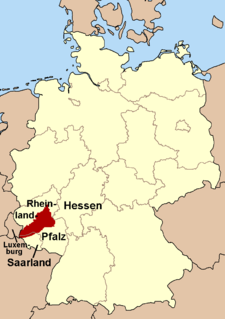
Rhineland-Palatinate is a western state of Germany. It covers 19,846 km2 (7,663 sq mi) and has about 4.05 million residents. It is the ninth largest and sixth most populous of the sixteen states. Mainz is the capital and largest city. Other cities are Ludwigshafen am Rhein, Koblenz, Trier, Kaiserslautern and Worms. It is bordered by North Rhine-Westphalia, Saarland, Baden-Württemberg and Hesse and by the countries France, Luxembourg and Belgium.

Palatinate (region) Historical region of Germany

The Palatinate is a historical region of Germany (Deutschland). In the Middle Ages it was known as the Rhenish Palatinate (Rheinpfalz) and Lower Palatinate (Unterpfalz), which strictly speaking designated only the western part of the Electorate of the Palatinate, as opposed to the Upper Palatinate (Oberpfalz). It occupies roughly the southernmost quarter of the German federal state of Rhineland-Palatinate (Rheinland-Pfalz), covering an area of 2,105 square miles (5,450 km2) with about 1.4 million inhabitants. Its residents are known as Palatines (Pfälzer).

Bad Dürkheim is a district in Rhineland-Palatinate, Germany. It is bounded by the districts of Kaiserslautern, Donnersbergkreis and Alzey-Worms, the city of Worms, the Rhein-Pfalz-Kreis, the city of Neustadt/Weinstraße, the districts of Südliche Weinstraße, the city of Landau, the district Südwestpfalz, and the city of Kaiserslautern.

Bad Kreuznach is a district in Rhineland-Palatinate, Germany. It is bounded by the districts of Rhein-Hunsrück, Mainz-Bingen, Alzey-Worms, Donnersbergkreis, Kusel and Birkenfeld.

Hunsrück Mountain range in Germany

The Hunsrück is a long, triangular, pronounced upland in Rhineland-Palatinate, Germany. It is bounded by the valleys of the Moselle-Saar (north-to-west), the Nahe (south), and the Rhine (east). It is continued by the Taunus mountains, past the Rhine and by the Eifel past the Moselle. To the south of the Nahe is a lower, hilly country forming the near bulk of the Palatinate region and all of the, smaller, Saarland. Below its north-east corner is Koblenz.

Bernkastel-Wittlich is a district in Rhineland-Palatinate, Germany. It is bounded by the districts of Vulkaneifel, Cochem-Zell, Rhein-Hunsrück, Birkenfeld, Trier-Saarburg and Bitburg-Prüm.

Südliche Weinstraße is a district (Kreis) in the south of Rhineland-Palatinate, Germany. Neighboring districts are Südwestpfalz, Bad Dürkheim, the district-free city Neustadt (Weinstraße), Rhein-Pfalz-Kreis, Germersheim, and the French département Bas-Rhin. The district-free city Landau is surrounded by the district.

Hattgenstein Municipality in Rhineland-Palatinate, Germany

Hattgenstein is an Ortsgemeinde – a municipality belonging to a Verbandsgemeinde, a kind of collective municipality – in the Birkenfeld district in Rhineland-Palatinate, Germany. It belongs to the Verbandsgemeinde of Birkenfeld, whose seat is in the like-named town.

Soonwald

The Soonwald is a forested, low mountain region, up to 657.5 m above sea level (NN), which forms part of the Hunsrück mountains in the German Central Uplands. It lies within the counties of Rhein-Hunsrück-Kreis and Bad Kreuznach in the state of Rhineland-Palatinate.

North Palatine Uplands Mountains in Germany

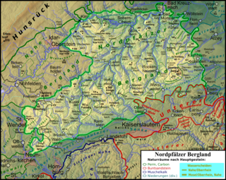
The North Palatine Uplands, sometimes shortened to Palatine Uplands, is a low mountain range and landscape unit in the German state of Rhineland-Palatinate and belongs mainly to the Palatinate region. It is part of the Saar-Nahe Uplands.

Idarkopf Tower

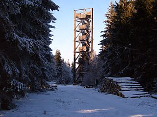
Idarkopf Tower, also known as Idarkopf Observation Tower for long, is a wooden German lattice observation tower on the summit of Mt. Idarkopf in the state of Rhineland-Palatinate. The observation tower on the 746 m-high (2,448 ft) mountain of Idarkopf has a total height of 28.50 m (94 ft). Built in 1980, the tower was constructed according to a certain kind of specialized wooden frame and was designed through triangular sketch. Staircases are uncountable because of the vast number of steps. The roof, which contains the observation deck, is considered the highest accessible point in the whole area, providing a unique view of the town nearby.

Walking routes in the Palatine Forest

Walking routes in the Palatine Forest fall into two categories. The first are longer walking routes, most of which are maintained by the Palatine Forest Club, or PWV, and which are linked to the national and international network of long distance paths. The second category are those local circular walks and themed walking routes, some of which are of wider regional importance, and which are maintained by municipal authorities. The Palatine Forest, as part of the Palatine Forest-North Vosges Biosphere Reserve, is an important conservation area. As a result, the Palatine Forest, the bunter sandstone landscape of the Palatine Forest Nature Park, the castles in the Dahner Felsenland and the cross-border paths into Alsace and the Vosges make the region particularly popular with ramblers and walkers.

Schwarzwälder Hochwald

The Schwarzwälder Hochwald, not to be confused with the High Black Forest, is the high south-western part of the Hunsrück in the German states of Saarland and Rhineland-Palatinate. The mountains are up to 816.32 m high.

Lützelsoon

The Lützelsoon is a part of the Hunsrück hills, 599.1 m above sea level (NN), in the county of Bad Kreuznach, in the state of Rhineland-Palatinate.

Saar-Hunsrück Nature Park

The Saar-Hunsrück Nature Park was established in 1980 and covers an area of just under 2,000 km² in the German states of Rhineland-Palatinate and the Saarland.

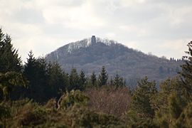
The Friedrichskopf near Brücken in the county of Birkenfeld in the German state of Rhineland-Palatinate is 707.4 m above sea level (NHN) and the highest mountain in the Dollberge, a small range in the Schwarzwälder Hochwald region of the Hunsrück mountains.

References

  1. 1 2 Inscription on the granite rock of the trigonometric point on the Donnersberg rock formation of Königsstuhl